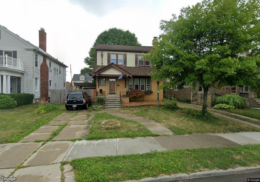
1221 Nottingham Rd Grosse Pointe Park, MI 48230
Estimated Value: $388,000 - $492,000
4
Beds
3
Baths
2,150
Sq Ft
$196/Sq Ft
Est. Value
About This Home
This home is located at 1221 Nottingham Rd, Grosse Pointe Park, MI 48230 and is currently estimated at $421,985, approximately $196 per square foot. 1221 Nottingham Rd is a home located in Wayne County with nearby schools including George Defer Elementary School, Pierce Middle School, and Grosse Pointe South High School.
Ownership History
Date
Name
Owned For
Owner Type
Purchase Details
Closed on
Jul 14, 2022
Sold by
Carsten Michael J
Bought by
Carsten Family Revocable Trust
Current Estimated Value
Purchase Details
Closed on
Nov 7, 2011
Sold by
Gellert Grant M and Gellert Ann C
Bought by
Carsten Michael J
Purchase Details
Closed on
Jun 18, 1997
Sold by
Drotar Gloria M and Drotar Frank
Bought by
Ann C and Gellert Grant M
Purchase Details
Closed on
Jun 19, 1995
Sold by
Sharpe Randall G
Bought by
Frank S Leszczewic and Drotar Gloria M
Create a Home Valuation Report for This Property
The Home Valuation Report is an in-depth analysis detailing your home's value as well as a comparison with similar homes in the area
Home Values in the Area
Average Home Value in this Area
Purchase History
| Date | Buyer | Sale Price | Title Company |
|---|---|---|---|
| Carsten Family Revocable Trust | -- | -- | |
| Carsten Michael J | $75,900 | None Available | |
| Ann C | $167,900 | -- | |
| Frank S Leszczewic | $120,000 | -- |
Source: Public Records
Tax History Compared to Growth
Tax History
| Year | Tax Paid | Tax Assessment Tax Assessment Total Assessment is a certain percentage of the fair market value that is determined by local assessors to be the total taxable value of land and additions on the property. | Land | Improvement |
|---|---|---|---|---|
| 2025 | $2,367 | $191,300 | $0 | $0 |
| 2024 | $2,367 | $187,200 | $0 | $0 |
| 2023 | $2,261 | $183,900 | $0 | $0 |
| 2022 | $2,148 | $167,000 | $0 | $0 |
| 2021 | $4,235 | $155,000 | $0 | $0 |
| 2019 | $6,119 | $139,100 | $0 | $0 |
| 2018 | $2,803 | $118,200 | $0 | $0 |
| 2017 | $4,740 | $78,000 | $0 | $0 |
| 2016 | $5,004 | $100,300 | $0 | $0 |
| 2015 | $7,663 | $97,300 | $0 | $0 |
| 2013 | $7,424 | $84,600 | $0 | $0 |
| 2012 | $2,679 | $89,600 | $22,300 | $67,300 |
Source: Public Records
Map
Nearby Homes
- 1254 Beaconsfield Ave
- 1306 Beaconsfield Ave Unit 1308
- 1316 Maryland St
- 2140 Alter Rd
- 1417 Beaconsfield Ave
- 1337 Wayburn St
- 1324 Wayburn St
- 2568 Alter Rd
- 1083 Lakepointe St
- 1048 Lakepointe St Unit A
- 1058 Lakepointe St
- 1032 Beaconsfield Ave
- 1451 Beaconsfield Ave
- 1350 Buckingham Rd
- 1308 Ashland St
- 1465 Maryland St
- 1449 Wayburn St
- 1148 Devonshire Rd
- 15239 Mack Ave
- 2190 Philip St
- 1225 Nottingham Rd
- 1215 Nottingham Rd
- 1231 Nottingham Rd
- 1209 Nottingham Rd
- 1224 Beaconsfield Ave
- 1216 Beaconsfield Ave
- 1216 Beaconsfield - Lower Ave
- 1220 Beaconsfield Ave
- 1220 Beaconsfield Ave Unit 1
- 1212 Beaconsfield Ave
- 1237 Nottingham Rd
- 1201 Nottingham Rd
- 15301 Kercheval Ave
- 1232 Beaconsfield Ave
- 1241 Nottingham Rd
- 1234 Beaconsfield Ave Unit 1236
- 1238 Beaconsfield Ave
- 1240 Beaconsfield Ave
- 1240 Beaconsfield Ave Unit 1242 Beaconsfield
- 1247 Nottingham Rd