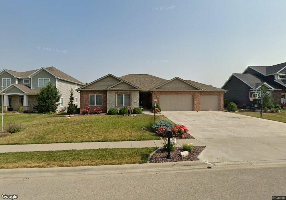
1221 Whetstone Dr Morton, IL 61550
Estimated Value: $466,000 - $512,000
3
Beds
3
Baths
2,015
Sq Ft
$243/Sq Ft
Est. Value
About This Home
This home is located at 1221 Whetstone Dr, Morton, IL 61550 and is currently estimated at $490,144, approximately $243 per square foot. 1221 Whetstone Dr is a home with nearby schools including Morton High School, Blessed Sacrament School, and Bethel Lutheran School.
Ownership History
Date
Name
Owned For
Owner Type
Purchase Details
Closed on
Sep 11, 2015
Sold by
Eigsti Construction Inc
Bought by
Yordy Michael E and Yordy Holly M
Current Estimated Value
Home Financials for this Owner
Home Financials are based on the most recent Mortgage that was taken out on this home.
Original Mortgage
$326,000
Outstanding Balance
$257,959
Interest Rate
4.13%
Mortgage Type
New Conventional
Estimated Equity
$232,185
Purchase Details
Closed on
Oct 16, 2013
Sold by
Davies Thomas E
Bought by
Smith Donald R and Smith Gillian L
Create a Home Valuation Report for This Property
The Home Valuation Report is an in-depth analysis detailing your home's value as well as a comparison with similar homes in the area
Home Values in the Area
Average Home Value in this Area
Purchase History
| Date | Buyer | Sale Price | Title Company |
|---|---|---|---|
| Yordy Michael E | $68,500 | -- | |
| Smith Donald R | $62,000 | First Community Title Svcs |
Source: Public Records
Mortgage History
| Date | Status | Borrower | Loan Amount |
|---|---|---|---|
| Open | Yordy Michael E | $326,000 |
Source: Public Records
Tax History Compared to Growth
Tax History
| Year | Tax Paid | Tax Assessment Tax Assessment Total Assessment is a certain percentage of the fair market value that is determined by local assessors to be the total taxable value of land and additions on the property. | Land | Improvement |
|---|---|---|---|---|
| 2024 | $9,982 | $146,110 | $24,770 | $121,340 |
| 2023 | $9,982 | $136,120 | $23,080 | $113,040 |
| 2022 | $9,654 | $125,010 | $21,200 | $103,810 |
| 2021 | $9,286 | $120,200 | $20,380 | $99,820 |
| 2020 | $9,001 | $119,010 | $20,180 | $98,830 |
| 2019 | $8,977 | $119,010 | $20,180 | $98,830 |
| 2018 | $8,813 | $119,010 | $20,180 | $98,830 |
| 2017 | $8,586 | $116,660 | $19,780 | $96,880 |
| 2016 | $8,420 | $116,660 | $19,780 | $96,880 |
| 2015 | $1,375 | $0 | $0 | $0 |
| 2013 | $11 | $160 | $160 | $0 |
Source: Public Records
Map
Nearby Homes
- 101 N Oregon Ave
- 1043 E Jefferson St
- 1021 E Madison St
- 314 N Oklahoma Ave
- 329 Pocono Ave
- 1414 S Missouri Ave
- 324 S Kansas Ave
- 300 S Kansas Ave
- 1156 Brentwood Rd
- 353 Pocono Ave
- 120 N Indiana Ave
- 430 N Montana Ave
- 519 Ohio Ct
- 392 E Forestwood St
- 328 N 3rd Ave
- 505 E Tyler St
- 324 N 2nd Ave
- 315 E Birchwood St
- 754 Taylor St
- 501-503 Pierce St
- 1225 Whetstone Dr
- Lot 127 Whetstone
- 1218 Weatherspoon Dr
- 1222 Whetstone Dr
- 1214 Weatherspoon Dr
- 1226 Whetstone Dr
- 1213 Whetstone Dr
- 1224 Weatherspoon Dr
- 1218 Whetstone Dr
- 1217 Whetstone Dr
- 1210 Weatherspoon Dr
- 1233 Whetstone Dr
- 1209 Whetstone Dr
- 1214 Whetstone Dr
- 1231 Whippoorwill Dr
- 1230 Whetstone Dr
- 1206 Weatherspoon Dr
- 1229 Whippoorwill Dr
- 1238 Weatherspoon Dr