12214 Kenneth Price Rd Springdale, AR 72762
Estimated payment $3,164/month
Highlights
- 4.45 Acre Lot
- Secluded Lot
- Shops
- Willis Shaw Elementary School Rated A-
- 1 Car Detached Garage
- Central Heating and Cooling System
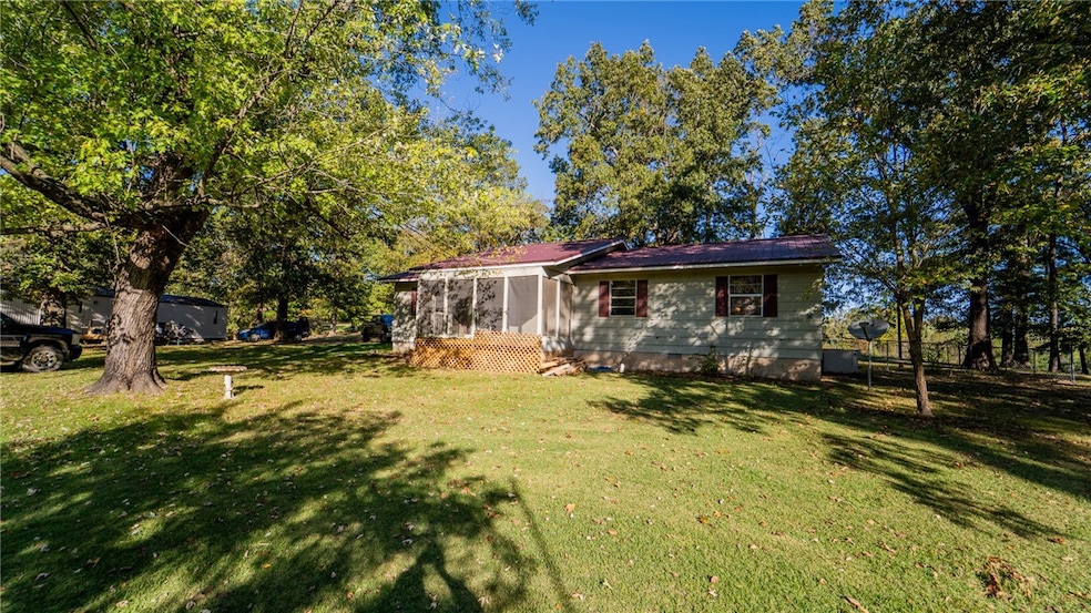
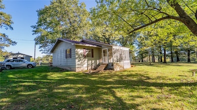
About This Home
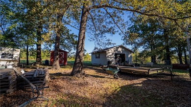
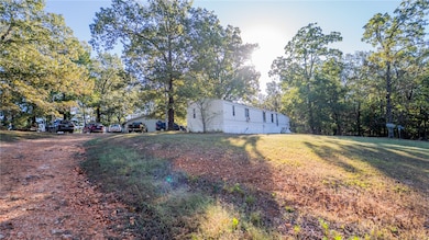
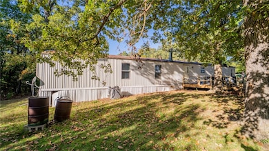
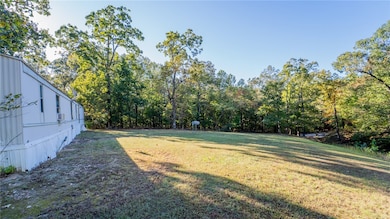
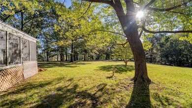
Situated on 4.5 acres, this property delivers country living minutes from everything NWA. Conveniently located near shopping, restaurants, and businesses this home is centrally located in Elm Springs but just minutes from Springdale and Tontitown and less than five minutes to the interstate. The home has good bones and plenty of space including a screened in porch overlooking a beautiful lawn and offers a fantastic opportunity for customization. Your pets will have a safe place to get some exercise in the fenced backyard. A mobile home provides the opportunity to immediately begin having rental income. Homes are being sold as-is. Don't miss out on this unique opportunity to own a property with income potential and both convenience and tranquility. Call today to schedule your private showing.
Listing Agent
Smith and Associates Real Estate Services Brokerage Phone: 479-595-1246 License #SA00090872 Listed on: 10/22/2025
Property Details
Home Type
- Multi-Family
Est. Annual Taxes
- $964
Year Built
- Built in 1982
Lot Details
- 4.45 Acre Lot
- Back Yard Fenced
- Secluded Lot
Parking
- 1 Car Detached Garage
Home Design
- Metal Roof
- Aluminum Siding
Interior Spaces
- 2,672 Sq Ft Home
- 1-Story Property
- Crawl Space
Flooring
- Carpet
- Laminate
Utilities
- Central Heating and Cooling System
- Electric Water Heater
Community Details
Overview
- 2 Units
- Elm Spgs Outlots Subdivision
Amenities
- Shops
Map
Home Values in the Area
Average Home Value in this Area
Tax History
| Year | Tax Paid | Tax Assessment Tax Assessment Total Assessment is a certain percentage of the fair market value that is determined by local assessors to be the total taxable value of land and additions on the property. | Land | Improvement |
|---|---|---|---|---|
| 2025 | $928 | $60,060 | $29,450 | $30,610 |
| 2024 | $955 | $60,060 | $29,450 | $30,610 |
| 2023 | $1,050 | $60,060 | $29,450 | $30,610 |
| 2022 | $1,085 | $41,360 | $18,270 | $23,090 |
| 2021 | $1,067 | $41,360 | $18,270 | $23,090 |
| 2020 | $1,058 | $41,360 | $18,270 | $23,090 |
| 2019 | $1,049 | $28,290 | $13,380 | $14,910 |
| 2018 | $1,074 | $28,290 | $13,380 | $14,910 |
| 2017 | $1,060 | $28,290 | $13,380 | $14,910 |
| 2016 | $1,060 | $28,290 | $13,380 | $14,910 |
| 2015 | $1,057 | $28,290 | $13,380 | $14,910 |
| 2014 | $1,046 | $27,110 | $10,880 | $16,230 |
Property History
| Date | Event | Price | List to Sale | Price per Sq Ft |
|---|---|---|---|---|
| 10/22/2025 10/22/25 | For Sale | $585,000 | -- | $219 / Sq Ft |
Purchase History
| Date | Type | Sale Price | Title Company |
|---|---|---|---|
| Quit Claim Deed | -- | -- | |
| Warranty Deed | $55,000 | -- | |
| Warranty Deed | -- | -- |
Source: Northwest Arkansas Board of REALTORS®
MLS Number: 1326604
APN: 750-00787-200
Disclaimer: Certain information contained herein is derived from information provided by parties other than Homes.com. All information provided is deemed reliable, but is not guaranteed to be accurate and should be independently verified.
![]() IDX information is provided exclusively for personal, non-commercial use, and may not be used for any purpose other than to identify prospective properties consumers may be interested in purchasing. Information is deemed reliable but not guaranteed.
IDX information is provided exclusively for personal, non-commercial use, and may not be used for any purpose other than to identify prospective properties consumers may be interested in purchasing. Information is deemed reliable but not guaranteed.
- 11920 Churchill Downs Dr
- 705 Oriole Dr
- Lot 24 Buck Ave
- 811 Valley Ln
- 10693 Snavely Rd
- 704 Quail Run
- 353 Waterfall Ln
- 0 Brush Creek Rd Unit 1327263
- 0 Millsap Rd Unit 1318059
- 1563 Ardemagni Rd
- 276 N Elm St
- 0 Lott Rd Unit 1321515
- 1145 Javello Rd
- 1145 Javello Rd Unit LotWP001
- 3423 Roma Dr
- 22717 Whippoorwill Ln
- 9149 Marchant Rd
- 4022 Als Dr
- 13528 Kelly Rd
- Gramercy Plan at Parkside
- 107 N Elm Springs Rd
- 527-592 Bradford Dr
- 3895 Baltic St
- 6738 Autumn Ave
- 202 Pebble Beach Dr
- 7263 Napa Valley Ln
- 257 Arborside Rd
- 422 Jtl Pkwy E
- 995 Pine Ave
- 967 Glass St Unit ID1241330P
- 523 Founders Park Dr E
- 5740 Lavender Ave
- 5653 Poppy Ave
- 221 Milas St
- 177 Milas St
- 1480 N 48th St
- 225 Bright St
- 1760 Pine Woods Rd
- 1513 Crestwood Hills Ln
- 1745 S Gene George Blvd
