

1222 South St Wrentham, MA 02093
Estimated payment $19,446/month
Highlights
- No HOA
- Additional Land
- Level Lot
- Delaney Elementary School Rated A
- Shops
About This Lot
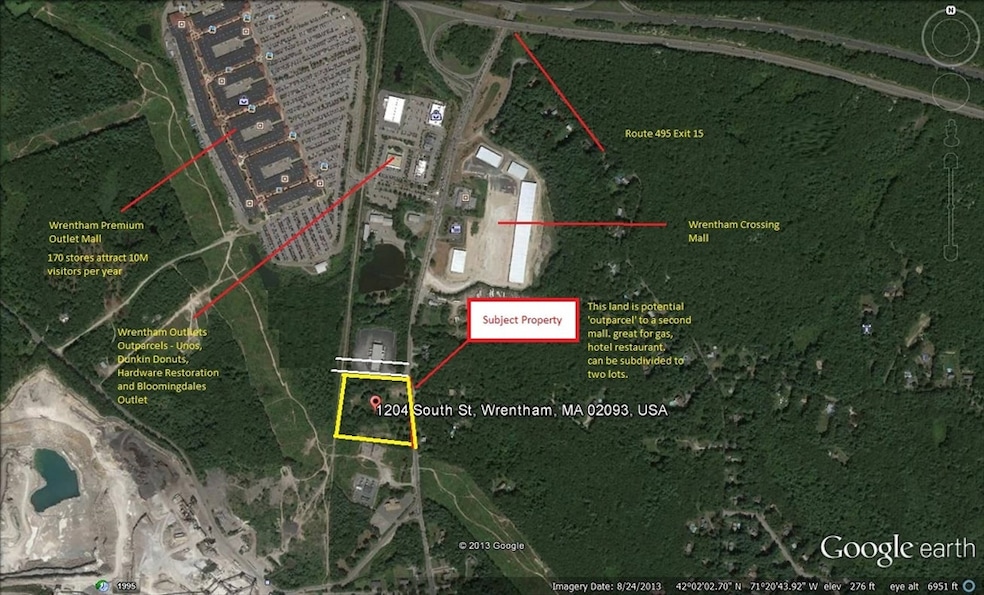
OVER 5 acres of Commercial Land Zoned C2, contained in 2 parcels, 1204 and 1222 South Street, with 410 FT of frontage on RT1A. Located close to the Premium Outlet Mall, at RT495, Exit 38. Sufficient Frontage to divide the lot into 2 conforming parcels. Engineering was done for an auto dealership (plan available), and a preliminary 21E was conducted and a Limited Removal was successfully completed. (report available) All Engineering work in the SELLER’s possession is conveyed at closing. This lot has commercial or industrial approved uses according to the USE TABLE ZONE C2 (available). Gas , Water and 3 PH power available. Private Septic.
Property Details
Property Type
- Land
Est. Annual Taxes
- $7,767
Lot Details
- 1.59 Acre Lot
- Property fronts a highway
- Property fronts an easement
- Level Lot
- 2 Lots in the community
- Additional Land
- Additional Parcels
- Property is zoned B2
Utilities
- Private Sewer
Listing and Financial Details
- Assessor Parcel Number M:K03 B:01 L:05,294550
Community Details
Recreation
- Electricity Available at Street
Additional Features
- No Home Owners Association
- Shops
Map
Home Values in the Area
Average Home Value in this Area
Tax History
| Year | Tax Paid | Tax Assessment Tax Assessment Total Assessment is a certain percentage of the fair market value that is determined by local assessors to be the total taxable value of land and additions on the property. | Land | Improvement |
|---|---|---|---|---|
| 2025 | $7,767 | $443,300 | $443,300 | $0 |
| 2024 | $7,700 | $443,300 | $443,300 | $0 |
| 2023 | $11,256 | $668,400 | $668,400 | $0 |
| 2022 | $12,152 | $668,400 | $668,400 | $0 |
| 2021 | $11,644 | $668,400 | $668,400 | $0 |
| 2020 | $11,551 | $628,100 | $628,100 | $0 |
| 2019 | $11,457 | $628,100 | $628,100 | $0 |
| 2018 | $11,543 | $632,500 | $632,500 | $0 |
| 2017 | $11,627 | $620,100 | $620,100 | $0 |
| 2016 | $11,277 | $607,900 | $607,900 | $0 |
| 2015 | $10,213 | $544,400 | $544,400 | $0 |
| 2014 | $9,694 | $522,600 | $522,600 | $0 |
Property History
| Date | Event | Price | Change | Sq Ft Price |
|---|---|---|---|---|
| 08/15/2025 08/15/25 | For Sale | $3,450,000 | -- | -- |
Purchase History
| Date | Type | Sale Price | Title Company |
|---|---|---|---|
| Quit Claim Deed | -- | None Available | |
| Deed | $895,000 | -- | |
| Deed | $60,000 | -- |
Mortgage History
| Date | Status | Loan Amount | Loan Type |
|---|---|---|---|
| Previous Owner | $150,000 | No Value Available |
Source: MLS Property Information Network (MLS PIN)
MLS Number: 73418506
APN: WREN-000003K-000001-000005
Disclaimer: Certain information contained herein is derived from information provided by parties other than Homes.com. All information provided is deemed reliable, but is not guaranteed to be accurate and should be independently verified.
![]() The property listing data and information, or the Images, set forth herein were provided to MLS Property Information Network, Inc. from third party sources, including sellers, lessors and public records, and were compiled by MLS Property Information Network, Inc. The property listing data and information, and the Images, are for the personal, non-commercial use of consumers having a good faith interest in purchasing or leasing listed properties of the type displayed to them and may not be used for any purpose other than to identify prospective properties which such consumers may have a good faith interest in purchasing or leasing. MLS Property Information Network, Inc. and its subscribers disclaim any and all representations and warranties as to the accuracy of the property listing data and information, or as to the accuracy of any of the Images, set forth herein.
The property listing data and information, or the Images, set forth herein were provided to MLS Property Information Network, Inc. from third party sources, including sellers, lessors and public records, and were compiled by MLS Property Information Network, Inc. The property listing data and information, and the Images, are for the personal, non-commercial use of consumers having a good faith interest in purchasing or leasing listed properties of the type displayed to them and may not be used for any purpose other than to identify prospective properties which such consumers may have a good faith interest in purchasing or leasing. MLS Property Information Network, Inc. and its subscribers disclaim any and all representations and warranties as to the accuracy of the property listing data and information, or as to the accuracy of any of the Images, set forth herein.
- 1204 South St
- 7 Munroe Dr
- 30 Nickerson Ln
- 12 Grant St
- 36 Field Cir
- 6 Morse Ave
- 12 Cranberry Ln
- 5 Field Cir
- 49 Sharlene Ln
- 131 Pleasant St Unit 1
- 95 Annawon Ave
- 440 Chestnut St
- 160 Washington St Unit 36
- 158 Washington St
- 130 Washington St
- 126 Washington St
- 124 Washington St
- 14 Earle Stewart Ln
- 12 Earle Stewart Ln
- 5 Farm Hill Ln
- 80 E Bacon St Unit 1
- 50 Ledgeview Way
- 85 Washington St
- 410 Eastside Rd
- 147 Creek St
- 563 N Washington St Unit B
- 18 Taunton St Unit 18A
- 146 Lakeside Ave
- 7 Taunton St
- 71 Messenger St
- 20-26 School St Unit 4
- 10 Independence Way
- 126 Division St Unit 1
- 100 Broad St Unit 3
- 45 Division St Unit 1
- 45 Division St Unit 3
- 23 Division St Unit 2
- 50 Leonard St Unit 1
- 346 Broadway Unit 8
- 51 Coach Rd
