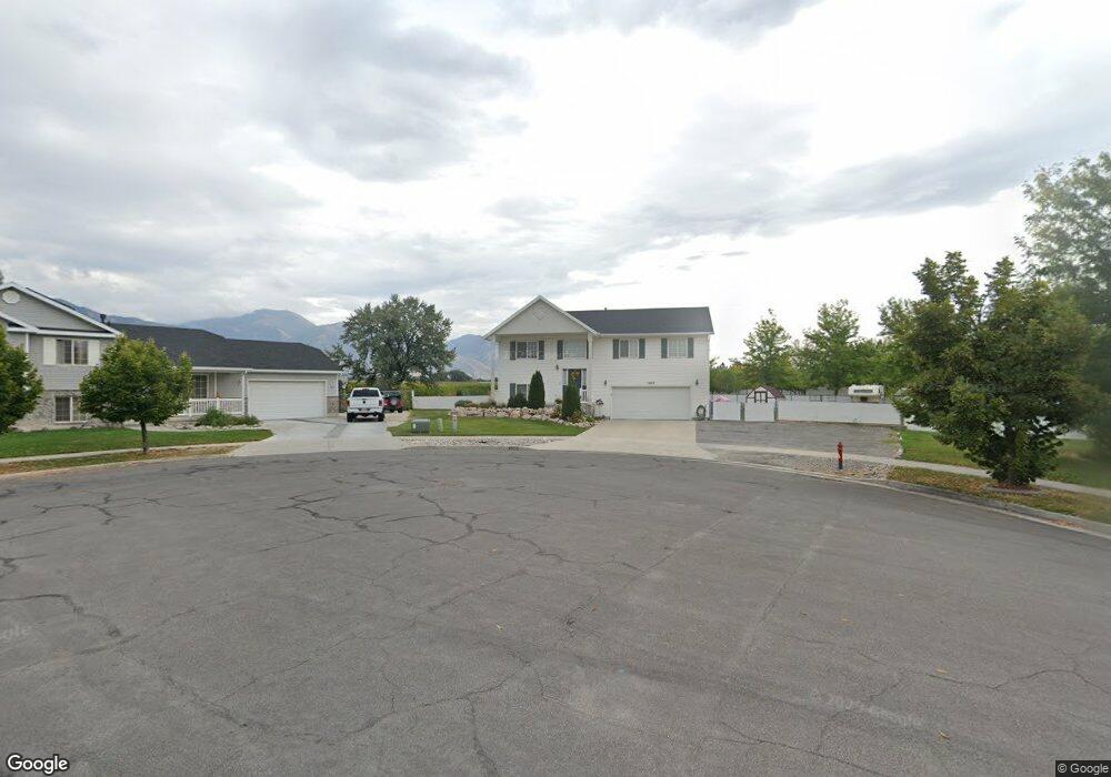
1222 W 630 S Logan, UT 84321
Woodruff NeighborhoodEstimated Value: $432,000 - $490,516
4
Beds
3
Baths
1,820
Sq Ft
$250/Sq Ft
Est. Value
About This Home
This home is located at 1222 W 630 S, Logan, UT 84321 and is currently estimated at $455,879, approximately $250 per square foot. 1222 W 630 S is a home located in Cache County with nearby schools including Mountainside School, South Cache Middle School, and Mountain Crest High School.
Ownership History
Date
Name
Owned For
Owner Type
Purchase Details
Closed on
Jul 28, 2016
Sold by
Rodriguez Martha Elena and Rodriguez Mariano
Bought by
Malmberg Joseph
Current Estimated Value
Home Financials for this Owner
Home Financials are based on the most recent Mortgage that was taken out on this home.
Original Mortgage
$165,500
Outstanding Balance
$131,332
Interest Rate
3.48%
Mortgage Type
New Conventional
Estimated Equity
$324,547
Purchase Details
Closed on
May 24, 2012
Sold by
Wright Timothy E
Bought by
Rodriguez Martha Elena and Rodriguez Mariano
Home Financials for this Owner
Home Financials are based on the most recent Mortgage that was taken out on this home.
Original Mortgage
$155,628
Interest Rate
3.75%
Mortgage Type
FHA
Create a Home Valuation Report for This Property
The Home Valuation Report is an in-depth analysis detailing your home's value as well as a comparison with similar homes in the area
Home Values in the Area
Average Home Value in this Area
Purchase History
We collect this data history from publicly available records. To have your information removed, we recommend requesting removal directly through your county’s website.
| Date | Buyer | Sale Price | Title Company |
|---|---|---|---|
| Malmberg Joseph | -- | Pinnacle Title | |
| Rodriguez Martha Elena | -- | American Secure Title Logan |
Source: Public Records
Mortgage History
We collect this data history from publicly available records. To have your information removed, we recommend requesting removal directly through your county’s website.
| Date | Status | Borrower | Loan Amount |
|---|---|---|---|
| Open | Malmberg Joseph | $165,500 | |
| Previous Owner | Rodriguez Martha Elena | $155,628 |
Source: Public Records
Tax History
| Year | Tax Paid | Tax Assessment Tax Assessment Total Assessment is a certain percentage of the fair market value that is determined by local assessors to be the total taxable value of land and additions on the property. | Land | Improvement |
|---|---|---|---|---|
| 2025 | $1,762 | $227,855 | $0 | $0 |
| 2024 | $1,809 | $226,645 | $0 | $0 |
| 2023 | $1,871 | $223,380 | $0 | $0 |
| 2022 | $1,674 | $186,670 | $0 | $0 |
| 2021 | $163 | $281,565 | $50,250 | $231,315 |
| 2020 | $1,438 | $222,865 | $50,250 | $172,615 |
| 2019 | $1,503 | $222,865 | $50,250 | $172,615 |
| 2018 | $1,479 | $200,350 | $50,250 | $150,100 |
| 2017 | $1,309 | $93,695 | $0 | $0 |
| 2016 | $1,357 | $93,695 | $0 | $0 |
| 2015 | $1,292 | $89,160 | $0 | $0 |
| 2014 | $1,168 | $89,160 | $0 | $0 |
| 2013 | -- | $89,160 | $0 | $0 |
Source: Public Records
Map
Nearby Homes
- 1210 W 575 S Unit 163
- 1210 W 575 S
- 1204 W 575 S
- 1264 W 500 S Unit 320
- 1225 W 500 S
- 1213 W 500 S
- 1269 W 500 S
- 1271 W 500 S
- 1099 Three Pointe Ave
- 370 S 1200 W Unit 2
- 402 S 1060 W
- 1312 W 350 S
- 959 Three Pointe Ave
- 420 S 1400 W
- 539 S 1580 W Unit 121
- 915 Knowles Ln
- 1230 W 240 S
- 1174 W 240 S
- 245 S 1280 W
- 511 S Rivergate Dr
Your Personal Tour Guide
Ask me questions while you tour the home.