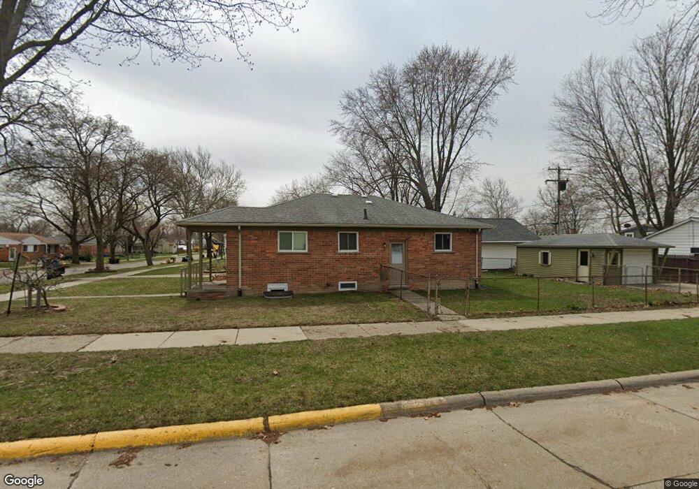
1223 Langley Blvd Clawson, MI 48017
Estimated Value: $168,000 - $355,000
3
Beds
2
Baths
1,029
Sq Ft
$242/Sq Ft
Est. Value
About This Home
This home is located at 1223 Langley Blvd, Clawson, MI 48017 and is currently estimated at $249,308, approximately $242 per square foot. 1223 Langley Blvd is a home located in Oakland County with nearby schools including Clawson High School, Japhet School, and Guardian Angels School.
Ownership History
Date
Name
Owned For
Owner Type
Purchase Details
Closed on
Dec 19, 2024
Sold by
Shamoun Willliam
Bought by
Langley North Llc
Current Estimated Value
Home Financials for this Owner
Home Financials are based on the most recent Mortgage that was taken out on this home.
Original Mortgage
$242,900
Outstanding Balance
$241,008
Interest Rate
6.84%
Mortgage Type
New Conventional
Estimated Equity
$8,300
Purchase Details
Closed on
May 3, 2023
Sold by
Parsons Dolores A
Bought by
Shamoun William
Create a Home Valuation Report for This Property
The Home Valuation Report is an in-depth analysis detailing your home's value as well as a comparison with similar homes in the area
Home Values in the Area
Average Home Value in this Area
Purchase History
| Date | Buyer | Sale Price | Title Company |
|---|---|---|---|
| Langley North Llc | -- | None Listed On Document | |
| Shamoun William | $160,000 | None Listed On Document | |
| Shamoun William | $160,000 | None Listed On Document | |
| Shamoun William | -- | None Listed On Document |
Source: Public Records
Mortgage History
| Date | Status | Borrower | Loan Amount |
|---|---|---|---|
| Open | Langley North Llc | $242,900 |
Source: Public Records
Tax History Compared to Growth
Tax History
| Year | Tax Paid | Tax Assessment Tax Assessment Total Assessment is a certain percentage of the fair market value that is determined by local assessors to be the total taxable value of land and additions on the property. | Land | Improvement |
|---|---|---|---|---|
| 2024 | $8,746 | $137,720 | $0 | $0 |
| 2023 | $2,733 | $106,830 | $0 | $0 |
| 2022 | $2,755 | $98,990 | $0 | $0 |
| 2021 | $2,698 | $92,550 | $0 | $0 |
| 2020 | $2,614 | $86,960 | $0 | $0 |
| 2019 | $2,701 | $82,630 | $0 | $0 |
| 2018 | $2,682 | $78,200 | $0 | $0 |
| 2017 | $2,666 | $75,510 | $0 | $0 |
| 2016 | $2,703 | $70,840 | $0 | $0 |
| 2015 | -- | $64,720 | $0 | $0 |
| 2014 | -- | $56,220 | $0 | $0 |
| 2011 | -- | $51,850 | $0 | $0 |
Source: Public Records
Map
Nearby Homes
- 1092 Shenandoah Dr
- 1226 Shenandoah Dr
- 908 W Elmwood Ave
- Fairfax Plan at The Village at Clawson Park
- Penrose Plan at The Village at Clawson Park
- 659 W Maple Rd
- 1341 Oakley Rd
- 846 Phillips Ave
- 4909 Coventry St Unit 287
- 1806 Torquay Ave
- 1936 Torquay Ave Unit 205
- 275 Council Ave
- 351 W Baker Ave
- 4921 N Crooks Rd Unit N-10
- 4952 Coventry St Unit 315
- 609 John M Ave
- 4909 Crooks Rd Unit C7
- 4909 Crooks Rd Unit 4
- 4921 Crooks Rd Unit M-10
- 1153 Kirts Blvd
- 1213 Langley Blvd
- 1226 Kenilworth Place
- 1203 Langley Blvd
- 1243 Langley Blvd
- 1210 Kenilworth Place
- 1161 Langley Blvd
- 1246 Kenilworth Place
- 1202 Kenilworth Place
- 1253 Langley Blvd
- 1090 Wright Dr
- 1151 Langley Blvd
- 1152 Kenilworth Place
- 1109 Wright Dr
- 1258 Kenilworth Place
- 1202 Langley Blvd
- 1160 Langley Blvd
- 1142 Kenilworth Place
- 1118 Wright Dr
- 1270 Kenilworth Place
- 1141 Langley Blvd