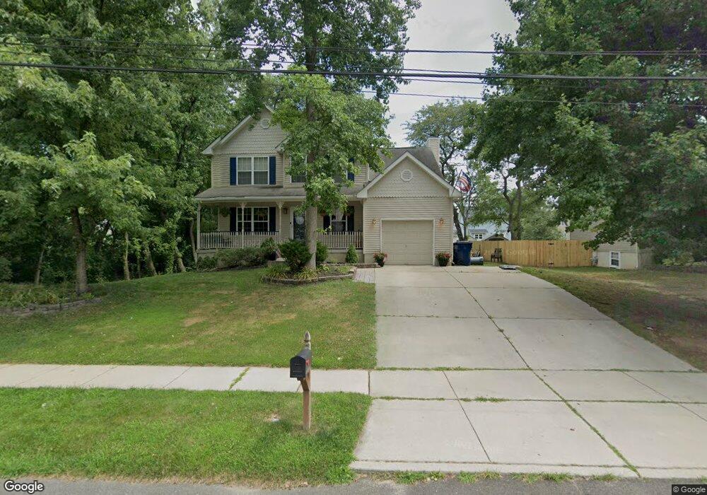
1224 Maple Ave Voorhees, NJ 08043
Estimated Value: $443,099 - $537,000
--
Bed
--
Bath
1,949
Sq Ft
$256/Sq Ft
Est. Value
About This Home
This home is located at 1224 Maple Ave, Voorhees, NJ 08043 and is currently estimated at $499,275, approximately $256 per square foot. 1224 Maple Ave is a home located in Camden County with nearby schools including Osage Elementary School, Voorhees Middle School, and Eastern Regional High School.
Ownership History
Date
Name
Owned For
Owner Type
Purchase Details
Closed on
Nov 12, 2001
Sold by
Kojeski Construction Co
Bought by
Macmurray Robert S and Macmurray Beth Ann
Current Estimated Value
Home Financials for this Owner
Home Financials are based on the most recent Mortgage that was taken out on this home.
Original Mortgage
$150,400
Outstanding Balance
$58,567
Interest Rate
6.67%
Estimated Equity
$440,708
Create a Home Valuation Report for This Property
The Home Valuation Report is an in-depth analysis detailing your home's value as well as a comparison with similar homes in the area
Home Values in the Area
Average Home Value in this Area
Purchase History
| Date | Buyer | Sale Price | Title Company |
|---|---|---|---|
| Macmurray Robert S | $195,150 | -- |
Source: Public Records
Mortgage History
| Date | Status | Borrower | Loan Amount |
|---|---|---|---|
| Open | Macmurray Robert S | $150,400 |
Source: Public Records
Tax History Compared to Growth
Tax History
| Year | Tax Paid | Tax Assessment Tax Assessment Total Assessment is a certain percentage of the fair market value that is determined by local assessors to be the total taxable value of land and additions on the property. | Land | Improvement |
|---|---|---|---|---|
| 2025 | $10,655 | $401,600 | $83,200 | $318,400 |
| 2024 | $10,465 | $247,800 | $84,600 | $163,200 |
| 2023 | $10,465 | $247,800 | $84,600 | $163,200 |
| 2022 | $10,254 | $247,800 | $84,600 | $163,200 |
| 2021 | $10,190 | $247,800 | $84,600 | $163,200 |
| 2020 | $10,135 | $247,800 | $84,600 | $163,200 |
| 2019 | $9,778 | $247,800 | $84,600 | $163,200 |
| 2018 | $9,714 | $247,800 | $84,600 | $163,200 |
| 2017 | $9,548 | $247,800 | $84,600 | $163,200 |
| 2016 | $9,109 | $247,800 | $84,600 | $163,200 |
| 2015 | $9,288 | $247,800 | $84,600 | $163,200 |
| 2014 | $9,171 | $247,800 | $84,600 | $163,200 |
Source: Public Records
Map
Nearby Homes
- 113 Harvard Ave
- 1800 S Burnt Mill Rd
- 18 Yale Ave
- 37 Dunhill Dr
- 1135 Gibbsboro Rd
- 1309 Locust Ave
- 804 S Burnt Mill Rd
- 5102 Tracy Ct
- 8 Pennsylvania Ave
- 3401 Jennifer Ct
- 401 S Browning Ave
- 1100 Rural Ave
- 7 Wright Ave
- 1193 Kirkwood-Gibbsboro R
- 6 Turnberry Ct
- 7 Sidney Ln
- 121 Union Ave
- 1256 Kirkwood-Gibbsboro R
- 116 Van Buren Rd Unit 8
- 120 Webster Ave
- 1222 Maple Ave
- 1226 Maple Ave
- 1225 Poplar Ave
- 1101 Poplar Ave
- 1219 Maple Ave
- 1103 Poplar Ave
- 1221 Maple Ave
- 1228 Maple Ave
- 1221 Poplar Ave
- 1217 Maple Ave
- 1109 Poplar Ave
- 1216 Maple Ave
- 1212 Cedar Ave
- 1213 Maple Ave
- 1224 Poplar Ave
- 1217 Poplar Ave
- 1220 Poplar Ave
- 1100 Poplar Ave
- 1212 Maple Ave
- 1104 Poplar Ave