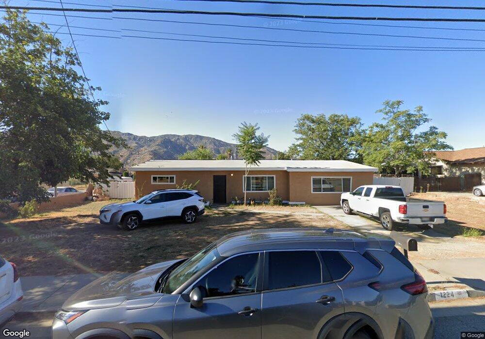
1224 W Westward Ave Banning, CA 92220
Estimated Value: $395,217 - $547,000
2
Beds
2
Baths
1,664
Sq Ft
$294/Sq Ft
Est. Value
About This Home
This home is located at 1224 W Westward Ave, Banning, CA 92220 and is currently estimated at $489,054, approximately $293 per square foot. 1224 W Westward Ave is a home located in Riverside County with nearby schools including Banning High School.
Ownership History
Date
Name
Owned For
Owner Type
Purchase Details
Closed on
Jul 28, 2020
Sold by
Calder Robin Lance and Calder Bonnie Leigh
Bought by
Calder Robin Lance and Calder Bonnie Leigh
Current Estimated Value
Home Financials for this Owner
Home Financials are based on the most recent Mortgage that was taken out on this home.
Original Mortgage
$154,000
Interest Rate
3.1%
Mortgage Type
New Conventional
Purchase Details
Closed on
Oct 26, 2018
Sold by
Calder Robin L and Calder Bonnie L
Bought by
Calder Robin Lance and Calder Bonnie Leigh
Create a Home Valuation Report for This Property
The Home Valuation Report is an in-depth analysis detailing your home's value as well as a comparison with similar homes in the area
Home Values in the Area
Average Home Value in this Area
Purchase History
| Date | Buyer | Sale Price | Title Company |
|---|---|---|---|
| Calder Robin Lance | -- | Chicago Title Company | |
| Calder Robin Lance | -- | Chicago Title Company | |
| Calder Robin Lance | -- | None Available |
Source: Public Records
Mortgage History
| Date | Status | Borrower | Loan Amount |
|---|---|---|---|
| Closed | Calder Robin Lance | $154,000 |
Source: Public Records
Tax History
| Year | Tax Paid | Tax Assessment Tax Assessment Total Assessment is a certain percentage of the fair market value that is determined by local assessors to be the total taxable value of land and additions on the property. | Land | Improvement |
|---|---|---|---|---|
| 2025 | $1,522 | $108,325 | $23,900 | $84,425 |
| 2023 | $1,522 | $104,121 | $22,973 | $81,148 |
| 2022 | $1,490 | $102,080 | $22,523 | $79,557 |
| 2021 | $1,462 | $100,080 | $22,082 | $77,998 |
| 2020 | $1,448 | $99,055 | $21,857 | $77,198 |
| 2019 | $1,426 | $97,114 | $21,429 | $75,685 |
| 2018 | $1,416 | $95,210 | $21,009 | $74,201 |
| 2017 | $1,392 | $93,345 | $20,598 | $72,747 |
| 2016 | $3,732 | $91,516 | $20,195 | $71,321 |
| 2015 | $3,723 | $90,143 | $19,893 | $70,250 |
| 2014 | $1,298 | $88,379 | $19,504 | $68,875 |
Source: Public Records
Map
Nearby Homes
- 666 Fashion Way
- 1174 W Hays St
- 612 S 22nd St
- 1117 W Hays St
- 1645 W Hays St
- 1137 W Williams St
- 266 N 14th St
- 437 W Ramsey St
- 979 W Nicolet St
- 0 Esperanza Firefighters Memorial Hwy
- 640 W Nicolet St
- 103 E Barbour St
- 0 Roberge Ave
- 554 Weather Way
- 2648 Hazy Way
- 457 W Nicolet St
- 0 E Ramsey St Unit IG26076411
- 0 Gorgonio Rd Unit SW25208341
- 0 Cabazon Unit CV26001873
- 0 Cabazon Unit CV25280859
- 1264 W Westward Ave
- 1180 W Westward Ave
- 895 S 12th St
- 1300 W Westward Ave
- 773 S 12th St
- 1271 W Westward Ave
- 892 S 12th St
- 892 April Ln
- 786 S 12th St
- 921 S 12th St
- 1293 W Westward Ave
- 610 S 12th St
- 743 S 12th St
- 1145 W Westward Ave
- 918 S 12th St
- 920 April Ln
- 1315 W Westward Ave
- 750 S 12th St
- 900 April Ln
- 0 April Ln
Your Personal Tour Guide
Ask me questions while you tour the home.