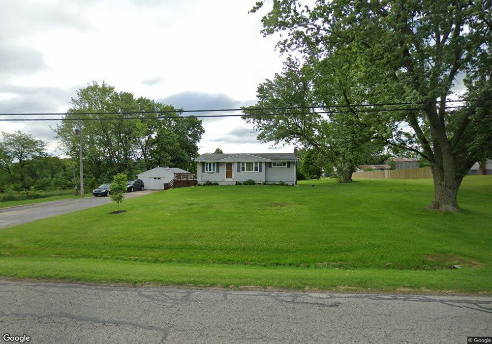
12241 Beard Rd New Springfield, OH 44443
Estimated Value: $152,904 - $185,000
3
Beds
1
Bath
984
Sq Ft
$168/Sq Ft
Est. Value
About This Home
This home is located at 12241 Beard Rd, New Springfield, OH 44443 and is currently estimated at $164,976, approximately $167 per square foot. 12241 Beard Rd is a home located in Mahoning County with nearby schools including Springfield Elementary School, Springfield Intermediate Middle School, and Springfield High School.
Ownership History
Date
Name
Owned For
Owner Type
Purchase Details
Closed on
May 10, 2013
Sold by
Struble Sharon
Bought by
Struble Fred L
Current Estimated Value
Purchase Details
Closed on
Jun 22, 2009
Sold by
Struble Fred L and Struble Sharon K
Bought by
Struble Fred L and Struble Sharon K
Purchase Details
Closed on
Feb 27, 1987
Bought by
Struble Fred L
Create a Home Valuation Report for This Property
The Home Valuation Report is an in-depth analysis detailing your home's value as well as a comparison with similar homes in the area
Home Values in the Area
Average Home Value in this Area
Purchase History
| Date | Buyer | Sale Price | Title Company |
|---|---|---|---|
| Struble Fred L | -- | Attorney | |
| Struble Fred L | -- | Attorney | |
| Struble Fred L | $27,000 | -- |
Source: Public Records
Tax History Compared to Growth
Tax History
| Year | Tax Paid | Tax Assessment Tax Assessment Total Assessment is a certain percentage of the fair market value that is determined by local assessors to be the total taxable value of land and additions on the property. | Land | Improvement |
|---|---|---|---|---|
| 2024 | $1,462 | $36,200 | $6,100 | $30,100 |
| 2023 | $1,437 | $36,200 | $6,100 | $30,100 |
| 2022 | $1,315 | $29,730 | $6,100 | $23,630 |
| 2021 | $1,325 | $29,730 | $6,100 | $23,630 |
| 2020 | $1,333 | $29,730 | $6,100 | $23,630 |
| 2019 | $1,248 | $26,830 | $6,100 | $20,730 |
| 2018 | $1,232 | $26,830 | $6,100 | $20,730 |
| 2017 | $1,229 | $26,830 | $6,100 | $20,730 |
| 2016 | $1,110 | $23,950 | $4,780 | $19,170 |
| 2015 | $1,080 | $23,950 | $4,780 | $19,170 |
| 2014 | $1,085 | $23,950 | $4,780 | $19,170 |
| 2013 | $1,075 | $23,950 | $4,780 | $19,170 |
Source: Public Records
Map
Nearby Homes
- 13131 Unity Rd
- 13000 Woodworth Rd
- 2399 Columbiana Rd
- 10495 Springfield Rd
- 10250 Springfield Rd
- 14413 Macklin Rd
- 170 Sandy Ct Unit 11
- 0 Meadowbrook Dr Unit 5110501
- 4035 Shelly Lynn Dr
- 4025 Shelly Lynn Dr
- 0 Sandy Ct Unit 5110511
- 10105 Carrie Ct
- 10115 Carrie Ct
- 2 Sandy Dr
- 0 Youngstown - Pittsburgh Rd Unit 5110475
- 10901 Main St
- 5272 Middletown Rd E
- 29 Shores Dr
- 42 Sycamore Dr
- 263 E Pine Lake Rd
- 12217 Beard Rd
- 12263 Beard Rd
- 12222 Beard Rd
- 0 Beard Unit 3190735
- 0 Beard Rd Unit 3269234
- 12291 Beard Rd
- 2919 E South Range Rd
- 12023 Beard Rd
- 3097 E South Range Rd
- 3076 E South Range Rd
- 2909 E South Range Rd
- 2851 E South Range Rd
- 3219 E South Range Rd
- 2950 E South Range Rd
- 3239 E South Range Rd
- 3150 E South Range Rd
- 3239 S Range Rd
- 3174 E South Range Rd
- 11933 Beard Rd
- 3216 E South Range Rd