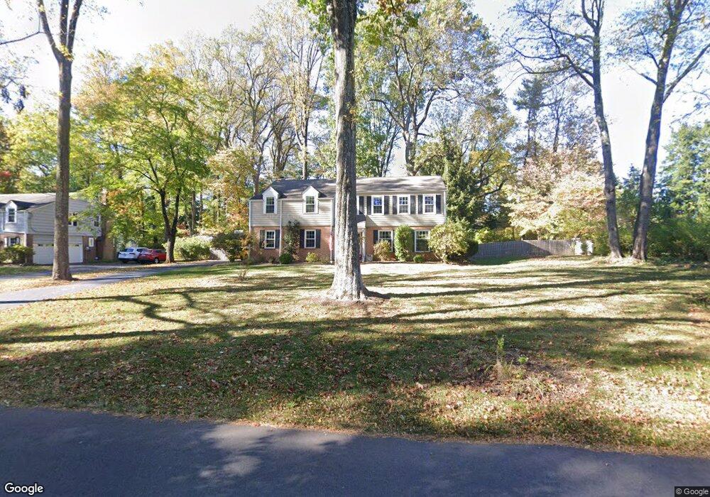
1225 Berwyn Paoli Rd Berwyn, PA 19312
Estimated Value: $929,821 - $1,020,000
4
Beds
3
Baths
2,752
Sq Ft
$358/Sq Ft
Est. Value
About This Home
This home is located at 1225 Berwyn Paoli Rd, Berwyn, PA 19312 and is currently estimated at $984,205, approximately $357 per square foot. 1225 Berwyn Paoli Rd is a home located in Chester County with nearby schools including Beaumont Elementary School, Tredyffrin-Easttown Middle School, and Conestoga Senior High School.
Ownership History
Date
Name
Owned For
Owner Type
Purchase Details
Closed on
Oct 1, 1997
Sold by
Smith David K and Smith Charlotte M
Bought by
Smith David K and Smith Charlotte M
Current Estimated Value
Purchase Details
Closed on
Jul 22, 1996
Sold by
Prell James Allen and Prell Jacqueline Dossett
Bought by
Smith David K and Smith Charlotte M
Create a Home Valuation Report for This Property
The Home Valuation Report is an in-depth analysis detailing your home's value as well as a comparison with similar homes in the area
Home Values in the Area
Average Home Value in this Area
Purchase History
| Date | Buyer | Sale Price | Title Company |
|---|---|---|---|
| Smith David K | -- | -- | |
| Smith David K | $260,000 | -- |
Source: Public Records
Tax History Compared to Growth
Tax History
| Year | Tax Paid | Tax Assessment Tax Assessment Total Assessment is a certain percentage of the fair market value that is determined by local assessors to be the total taxable value of land and additions on the property. | Land | Improvement |
|---|---|---|---|---|
| 2025 | $8,535 | $242,320 | $53,790 | $188,530 |
| 2024 | $8,535 | $242,320 | $53,790 | $188,530 |
| 2023 | $8,018 | $242,320 | $53,790 | $188,530 |
| 2022 | $7,811 | $242,320 | $53,790 | $188,530 |
| 2021 | $7,662 | $242,320 | $53,790 | $188,530 |
| 2020 | $7,451 | $242,320 | $53,790 | $188,530 |
| 2019 | $7,216 | $242,320 | $53,790 | $188,530 |
| 2018 | $7,073 | $242,320 | $53,790 | $188,530 |
| 2017 | $6,904 | $242,320 | $53,790 | $188,530 |
| 2016 | -- | $242,320 | $53,790 | $188,530 |
| 2015 | -- | $242,320 | $53,790 | $188,530 |
| 2014 | -- | $242,320 | $53,790 | $188,530 |
Source: Public Records
Map
Nearby Homes
- 32 Manchester Ct
- 1242 Old Lancaster Rd
- 896 Conestoga Rd
- 5 Kent Ln
- 1441 Berwyn Paoli Rd
- 91 Central Ave
- 327 Stoney Knoll Lane - Lot 5
- 211 Wooded Way
- 119 Waterloo Ave
- 553 Woodside Ave
- 541 Woodside Ave
- 520 Hawthorne Place
- 521 Foxwood Ln
- 109 Vincent Rd
- 2102 Quail Ridge Dr
- 1304 Weatherstone Dr Unit 1304
- 1705 Weatherstone Dr
- 1602 Weatherstone Dr Unit 1602
- 320 Landsende Rd
- 2000 Saint Andrews Dr
- 1237 Berwyn Paoli Rd
- 1215 Berwyn Paoli Rd
- 1224 Lancaster Ave
- 1240 Lancaster Ave
- 1247 Berwyn Paoli Rd
- 1248 Lancaster Ave
- 107 Cherry Ln
- 1 Cherry Ln
- 2 Cherry Ln
- 1206 Lancaster Ave
- 1207 Berwyn Paoli Rd
- 1250 Berwyn Paoli Rd
- 1237 Lancaster Ave Unit Mezzanine Two
- 1237 Lancaster Ave Unit Mezzanine One
- 1237 Lancaster Ave
- 1237 Lancaster Ave
- 1237 Lancaster Ave Unit 3
- 1237 Lancaster Ave Unit 1
- 1263 Berwyn Paoli Rd
- 1258 Lancaster Ave