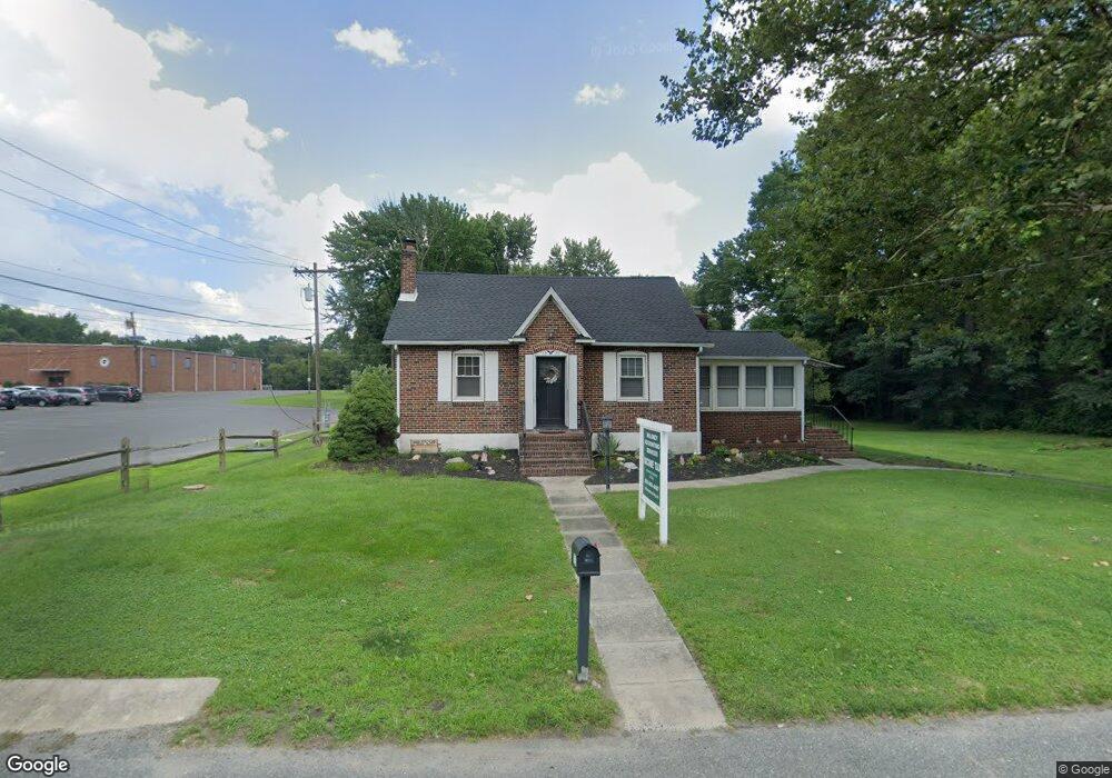
1225 Delsea Dr Westville, NJ 08093
Deptford Township NeighborhoodEstimated Value: $276,669 - $308,000
--
Bed
--
Bath
1,410
Sq Ft
$208/Sq Ft
Est. Value
About This Home
This home is located at 1225 Delsea Dr, Westville, NJ 08093 and is currently estimated at $292,667, approximately $207 per square foot. 1225 Delsea Dr is a home located in Gloucester County with nearby schools including Deptford Township High School and Holy Angels Catholic School.
Ownership History
Date
Name
Owned For
Owner Type
Purchase Details
Closed on
Jul 27, 2007
Sold by
Estate Of Susan K Pisker
Bought by
Maloney Thomas P
Current Estimated Value
Home Financials for this Owner
Home Financials are based on the most recent Mortgage that was taken out on this home.
Original Mortgage
$164,800
Outstanding Balance
$104,663
Interest Rate
6.72%
Mortgage Type
New Conventional
Estimated Equity
$188,004
Create a Home Valuation Report for This Property
The Home Valuation Report is an in-depth analysis detailing your home's value as well as a comparison with similar homes in the area
Home Values in the Area
Average Home Value in this Area
Purchase History
| Date | Buyer | Sale Price | Title Company |
|---|---|---|---|
| Maloney Thomas P | $206,000 | Foundation Title Llc |
Source: Public Records
Mortgage History
| Date | Status | Borrower | Loan Amount |
|---|---|---|---|
| Open | Maloney Thomas P | $164,800 |
Source: Public Records
Tax History Compared to Growth
Tax History
| Year | Tax Paid | Tax Assessment Tax Assessment Total Assessment is a certain percentage of the fair market value that is determined by local assessors to be the total taxable value of land and additions on the property. | Land | Improvement |
|---|---|---|---|---|
| 2025 | $5,865 | $163,600 | $43,500 | $120,100 |
| 2024 | $5,677 | $163,600 | $43,500 | $120,100 |
| 2023 | $5,677 | $163,600 | $43,500 | $120,100 |
| 2022 | $5,636 | $163,600 | $43,500 | $120,100 |
| 2021 | $5,243 | $163,600 | $43,500 | $120,100 |
| 2020 | $5,492 | $163,600 | $43,500 | $120,100 |
| 2019 | $5,387 | $163,600 | $43,500 | $120,100 |
| 2018 | $5,266 | $163,600 | $43,500 | $120,100 |
| 2017 | $5,126 | $163,600 | $43,500 | $120,100 |
| 2016 | $5,021 | $163,600 | $43,500 | $120,100 |
| 2015 | $4,865 | $163,600 | $43,500 | $120,100 |
| 2014 | $4,739 | $163,600 | $43,500 | $120,100 |
Source: Public Records
Map
Nearby Homes
- 1240 Delsea Dr
- 308 Winding Way Unit C8
- 715 Winding Way Unit G15
- 416 Winding Way
- 406 Winding Way
- 787 Tacoma Blvd
- 340 Arline Ave
- 615 Lot: 1.01 Carteret
- 431 Dogwood Dr
- 615 L1.02 Carteret Ave
- 53 Knollwood Dr
- 416 Dogwood Dr
- 54 Knollwood Dr
- 761 Carteret Ave
- 38 Pinecrest Dr
- 622 Sweetgum Ln Unit 145
- 1093 Delsea Dr
- 433 Trowbridge Ave
- 128 Pennsbury Ln
- 161 Riggins Blvd
- 1218 Delsea Dr
- 1237 Delsea Dr
- 1230 Delsea Dr
- 1210 Delsea Dr
- 1210 Delsea Dr
- 1210 Delsea Dr Unit 1212
- 1219 Delsea Dr
- 1241 Delsea Dr
- 574 Deptford Ave
- 1222 Delsea Dr
- 1245 Delsea Dr Unit 1/3B3A
- 1245 Delsea Dr
- 18 Taras Ave
- 1255 Delsea Dr
- 1200 Delsea Dr Unit 2
- 1200 Delsea Dr Unit 6
- 1200 Delsea Dr Unit 8
- 1200 Delsea Dr Unit 10
- 1200 Delsea Dr Unit 12
- 1200 Delsea Dr Unit 13