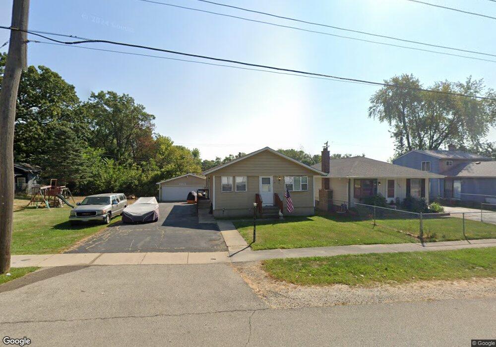
1225 Lotus Dr Round Lake Beach, IL 60073
Estimated Value: $224,000 - $257,000
3
Beds
2
Baths
975
Sq Ft
$242/Sq Ft
Est. Value
About This Home
This home is located at 1225 Lotus Dr, Round Lake Beach, IL 60073 and is currently estimated at $235,649, approximately $241 per square foot. 1225 Lotus Dr is a home located in Lake County with nearby schools including Raymond Ellis Elementary School, Round Lake Middle School, and Round Lake High School.
Ownership History
Date
Name
Owned For
Owner Type
Purchase Details
Closed on
Jul 29, 2013
Sold by
Moyer Margaret and Moyer John
Bought by
Cullom Steven J and Cullom Victoria L
Current Estimated Value
Purchase Details
Closed on
Jul 13, 1999
Sold by
Cullom Michael J
Bought by
Cullom David M and Cullom Margaret F
Home Financials for this Owner
Home Financials are based on the most recent Mortgage that was taken out on this home.
Original Mortgage
$82,500
Interest Rate
7.77%
Create a Home Valuation Report for This Property
The Home Valuation Report is an in-depth analysis detailing your home's value as well as a comparison with similar homes in the area
Home Values in the Area
Average Home Value in this Area
Purchase History
| Date | Buyer | Sale Price | Title Company |
|---|---|---|---|
| Cullom Steven J | $80,000 | Affinity Title Services Llc | |
| Cullom David M | -- | Chicago Title Insurance Co |
Source: Public Records
Mortgage History
| Date | Status | Borrower | Loan Amount |
|---|---|---|---|
| Previous Owner | Cullom David M | $82,500 |
Source: Public Records
Tax History Compared to Growth
Tax History
| Year | Tax Paid | Tax Assessment Tax Assessment Total Assessment is a certain percentage of the fair market value that is determined by local assessors to be the total taxable value of land and additions on the property. | Land | Improvement |
|---|---|---|---|---|
| 2024 | $4,100 | $57,357 | $9,874 | $47,483 |
| 2023 | $4,093 | $50,133 | $8,630 | $41,503 |
| 2022 | $4,093 | $47,184 | $7,806 | $39,378 |
| 2021 | $4,349 | $45,352 | $7,503 | $37,849 |
| 2020 | $3,945 | $41,296 | $7,139 | $34,157 |
| 2019 | $3,820 | $39,620 | $6,849 | $32,771 |
| 2018 | $3,849 | $35,765 | $6,637 | $29,128 |
| 2017 | $3,759 | $33,642 | $6,243 | $27,399 |
| 2016 | $3,579 | $31,055 | $5,763 | $25,292 |
| 2015 | $3,453 | $28,371 | $5,265 | $23,106 |
| 2014 | $3,931 | $32,347 | $4,941 | $27,406 |
| 2012 | $3,944 | $33,782 | $5,160 | $28,622 |
Source: Public Records
Map
Nearby Homes
- 1315 Cherokee Dr
- 630 Morningside Dr
- 1506 Brentwood Dr
- 905 Buena Vista Dr
- 1503 Cherokee Dr
- 1401 Meadowbrook Dr
- 922 Idlewild Dr
- 1110 N Fairfield Rd
- 915 Mayfield Dr
- 1410 Juneway Terrace
- 614 W Pheasant Ct
- 1610 Goldenrod Terrace
- 24513 W Stub Ave
- 1309 N Channel Dr Unit N
- 1163 N Red Oak Cir Unit 4
- 347 N Red Oak Cir Unit 406
- 1248 N Red Oak Cir Unit 2
- 1160 N Red Oak Cir Unit 1160-1
- 1316 N Red Oak Cir Unit 2
- 24471 W Poplar St
- 1223 Lotus Dr Unit 1
- 1303 Lotus Dr
- 1219 Lotus Dr
- 801 Oakwood Dr Unit 1
- 1226 Lotus Dr
- 1302 Lotus Dr
- 1224 Lotus Dr
- 1222 Lotus Dr
- 729 Oakwood Dr
- 809 Oakwood Dr
- 1217 Lotus Dr
- 725 Oakwood Dr
- 1220 Lotus Dr
- 811 Oakwood Dr
- 723 Oakwood Dr
- 1215 Lotus Dr
- 1218 Lotus Dr Unit 1
- 1225 Woodridge Dr
- 1301 Woodridge Dr
- 1223 Woodridge Dr