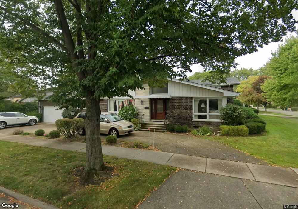
1225 N Branch Rd Wilmette, IL 60091
Estimated Value: $741,000 - $983,000
4
Beds
3
Baths
2,108
Sq Ft
$392/Sq Ft
Est. Value
About This Home
This home is located at 1225 N Branch Rd, Wilmette, IL 60091 and is currently estimated at $826,090, approximately $391 per square foot. 1225 N Branch Rd is a home located in Cook County with nearby schools including Marie Murphy School, Avoca West Elementary School, and New Trier Township High School - Northfield.
Ownership History
Date
Name
Owned For
Owner Type
Purchase Details
Closed on
Dec 19, 2011
Sold by
Domash Eleanor
Bought by
Luu Vinh T and Chung Anh H
Current Estimated Value
Home Financials for this Owner
Home Financials are based on the most recent Mortgage that was taken out on this home.
Original Mortgage
$378,400
Outstanding Balance
$258,851
Interest Rate
4.01%
Mortgage Type
New Conventional
Estimated Equity
$567,239
Purchase Details
Closed on
Sep 30, 2007
Sold by
Domash Eleanor
Bought by
Domash Eleanor and Henry Domash Family Trust
Purchase Details
Closed on
Dec 8, 2005
Sold by
Chicago Title Land Trust Co
Bought by
Domash Henry and Domash Eleanor
Create a Home Valuation Report for This Property
The Home Valuation Report is an in-depth analysis detailing your home's value as well as a comparison with similar homes in the area
Home Values in the Area
Average Home Value in this Area
Purchase History
| Date | Buyer | Sale Price | Title Company |
|---|---|---|---|
| Luu Vinh T | $473,000 | Fort Dearborn Land Title Llc | |
| Domash Eleanor | -- | None Available | |
| Domash Henry | -- | None Available |
Source: Public Records
Mortgage History
| Date | Status | Borrower | Loan Amount |
|---|---|---|---|
| Open | Luu Vinh T | $378,400 |
Source: Public Records
Tax History Compared to Growth
Tax History
| Year | Tax Paid | Tax Assessment Tax Assessment Total Assessment is a certain percentage of the fair market value that is determined by local assessors to be the total taxable value of land and additions on the property. | Land | Improvement |
|---|---|---|---|---|
| 2024 | $10,483 | $49,922 | $13,312 | $36,610 |
| 2023 | $9,936 | $49,922 | $13,312 | $36,610 |
| 2022 | $9,936 | $49,922 | $13,312 | $36,610 |
| 2021 | $8,590 | $37,694 | $9,568 | $28,126 |
| 2020 | $8,499 | $37,694 | $9,568 | $28,126 |
| 2019 | $8,342 | $41,423 | $9,568 | $31,855 |
| 2018 | $9,258 | $43,634 | $7,904 | $35,730 |
| 2017 | $9,602 | $46,080 | $7,904 | $38,176 |
| 2016 | $9,256 | $46,080 | $7,904 | $38,176 |
| 2015 | $8,503 | $38,447 | $6,448 | $31,999 |
| 2014 | $8,375 | $38,447 | $6,448 | $31,999 |
| 2013 | $7,986 | $38,447 | $6,448 | $31,999 |
Source: Public Records
Map
Nearby Homes
- 1133 Manor Dr
- 3507 Greenwood Ave
- 32 Meadowview Dr
- 5020 Arbor Ln Unit 203
- 3030 Arbor Ln Unit 203
- 5040 Arbor Ln Unit 303
- 228 Mark Dr
- 828 Lavergne Ave
- 15 Landmark
- 1656 Harding Rd
- 62 Woodley Rd
- 726 Lawler Ave
- 4072 Bunker Ln
- 711 Becker Rd
- 185 Happ Rd
- 805 Hibbard Rd
- 120 Riverside Dr
- 1201 Harms Rd
- 737 Becker Rd
- 1115 Hunter Rd
- 3525 Riverside Dr
- 1317 N Branch Rd Unit Lot R14
- 1317 N Branch Rd Unit F01
- 1317 N Branch Rd Unit Lot B14
- 1317 N Branch Rd Unit Lot A16
- 1317 N Branch Rd Unit Lot B02
- 1221 N Branch Rd
- 1224 N Branch Rd
- 3529 Riverside Dr
- 1215 N Branch Rd
- 1220 N Branch Rd
- 3518 Riverside Dr
- 3501 Riverside Dr
- 3514 Riverside Dr
- 3524 Riverside Dr
- 1214 N Branch Rd Unit S
- 3506 Riverside Dr
- 1211 N Branch Rd
- 1226 Manor Dr
- 3535 Riverside Dr