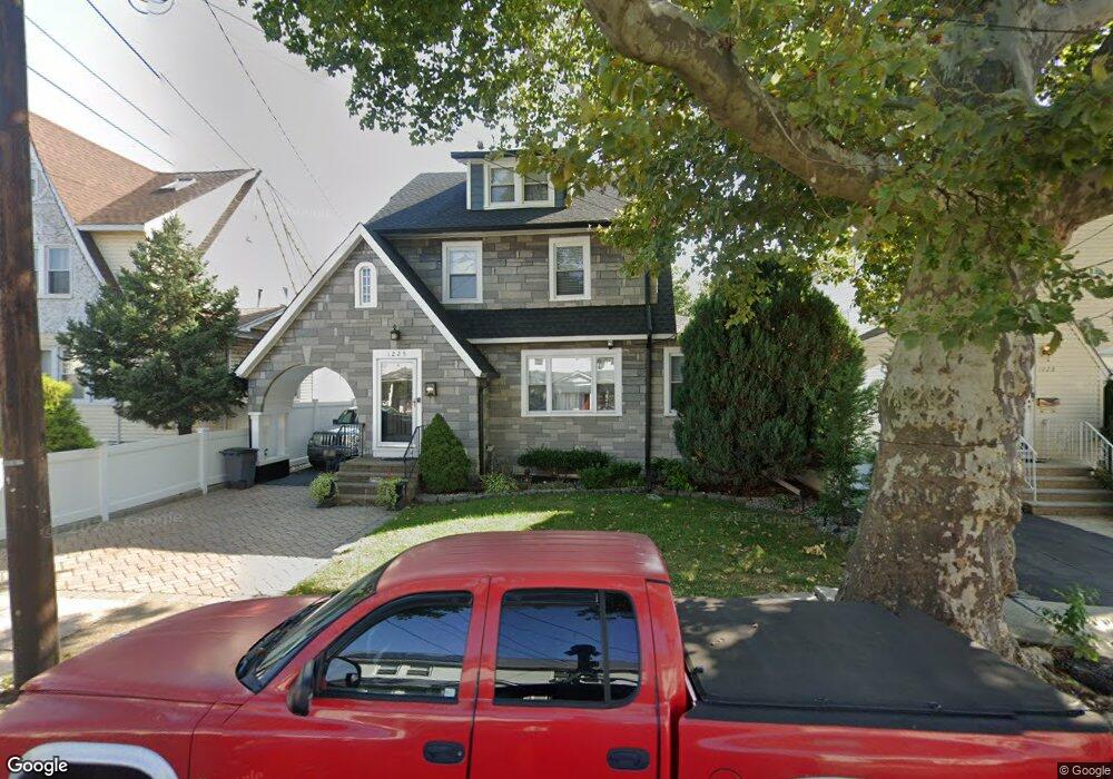
1225 Robert St Hillside, NJ 07205
Westminster NeighborhoodEstimated Value: $494,549 - $563,000
Studio
--
Bath
1,730
Sq Ft
$313/Sq Ft
Est. Value
About This Home
This home is located at 1225 Robert St, Hillside, NJ 07205 and is currently estimated at $542,137, approximately $313 per square foot. 1225 Robert St is a home located in Union County with nearby schools including Abram P. Morris-Saybrook Elementary School, Hurden Looker School, and Ola Edwards Community School.
Ownership History
Date
Name
Owned For
Owner Type
Purchase Details
Closed on
Oct 20, 2000
Sold by
Acevedo Wilson and Acevedo Nancy
Bought by
Cabrera Wilfredo and Cabrera Marisol
Current Estimated Value
Home Financials for this Owner
Home Financials are based on the most recent Mortgage that was taken out on this home.
Original Mortgage
$152,000
Outstanding Balance
$55,076
Interest Rate
7.83%
Estimated Equity
$487,061
Create a Home Valuation Report for This Property
The Home Valuation Report is an in-depth analysis detailing your home's value as well as a comparison with similar homes in the area
Home Values in the Area
Average Home Value in this Area
Purchase History
We collect this data history from publicly available records. To have your information removed, we recommend requesting removal directly through your county’s website.
| Date | Buyer | Sale Price | Title Company |
|---|---|---|---|
| Cabrera Wilfredo | $160,000 | -- |
Source: Public Records
Mortgage History
We collect this data history from publicly available records. To have your information removed, we recommend requesting removal directly through your county’s website.
| Date | Status | Borrower | Loan Amount |
|---|---|---|---|
| Open | Cabrera Wilfredo | $152,000 |
Source: Public Records
Tax History
| Year | Tax Paid | Tax Assessment Tax Assessment Total Assessment is a certain percentage of the fair market value that is determined by local assessors to be the total taxable value of land and additions on the property. | Land | Improvement |
|---|---|---|---|---|
| 2025 | $10,341 | $125,300 | $68,300 | $57,000 |
| 2024 | $10,040 | $125,300 | $68,300 | $57,000 |
| 2023 | $10,040 | $125,300 | $68,300 | $57,000 |
| 2022 | $9,948 | $125,300 | $68,300 | $57,000 |
| 2021 | $9,882 | $125,300 | $68,300 | $57,000 |
| 2020 | $9,825 | $125,300 | $68,300 | $57,000 |
| 2019 | $9,634 | $125,300 | $68,300 | $57,000 |
| 2018 | $9,538 | $125,300 | $68,300 | $57,000 |
| 2017 | $9,480 | $125,300 | $68,300 | $57,000 |
| 2016 | $9,469 | $125,300 | $68,300 | $57,000 |
| 2015 | $9,385 | $125,300 | $68,300 | $57,000 |
| 2014 | $9,679 | $131,300 | $68,300 | $63,000 |
Source: Public Records
Map
Nearby Homes
- 1229 Robert St
- 1250 N Broad St Unit A1
- 1200 Salem Ave
- 24 Hollywood Ave
- 52 Hollywood Ave
- 137 Fairbanks St
- 52 Looker St
- 39 Hurden St
- 219 Hollywood Ave
- 161 Virginia St
- 1019 Elmer Place
- 1071 Prospect St Unit 3
- 1408 Lexington Place Unit 1410
- 29 Long Ave
- 325 Hollywood Ave
- 75 Hillside Ave
- 1444 N Broad St
- 1038 Fairview Place
- 1464 Morris Place
- 917 Westminster Ave
- 1223 Robert St
- 1233 Robert St Unit 5
- 1233 Robert St Unit 2
- 1221 Robert St
- 1237 Robert St
- 1215 Robert St
- 1230 Robert St
- 1226 Robert St Unit 1228
- 1222 Robert St Unit 4
- 1241 Robert St
- 1213 Robert St
- 1238A N Broad St Unit 1238A
- 1232 Robert St
- 1218 Robert St Unit 20
- 1236B N Broad St
- 1238B N Broad St
- 1236A N Broad St
- 1236 Robert St
- 1211 Robert St
- 1240B N Broad St
Your Personal Tour Guide
Ask me questions while you tour the home.