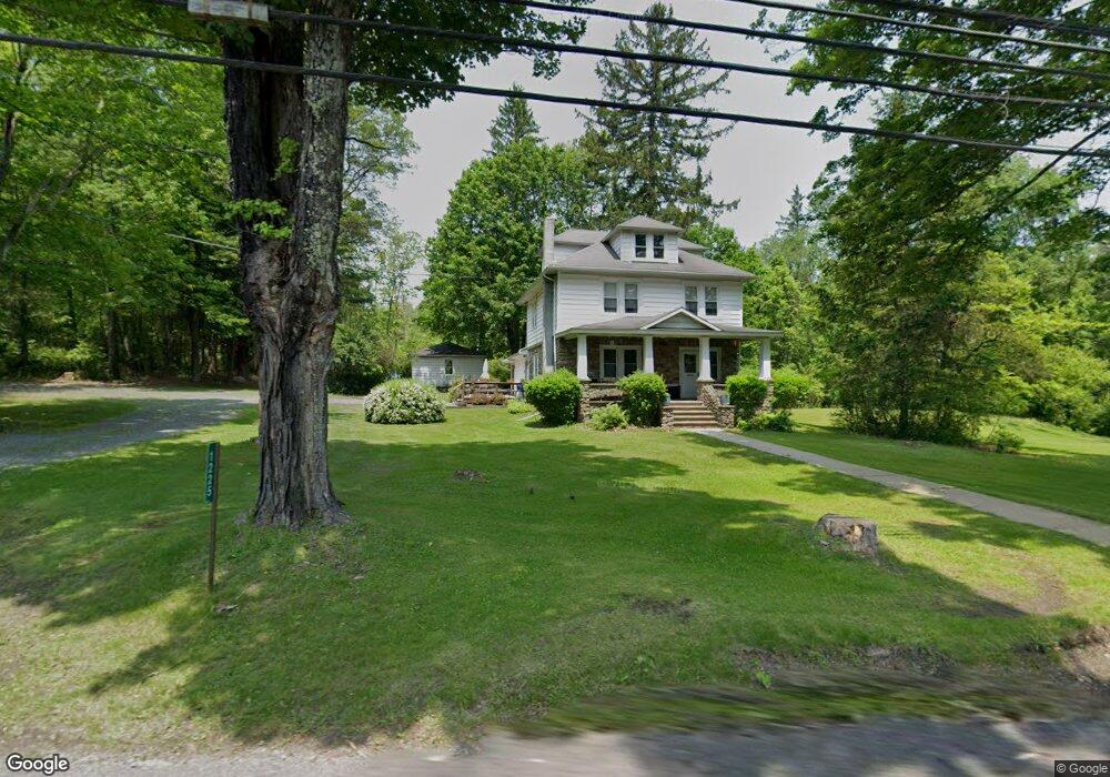
1225 Route 390 Cresco, PA 18326
Estimated Value: $293,000 - $357,000
3
Beds
2
Baths
2,293
Sq Ft
$140/Sq Ft
Est. Value
About This Home
This home is located at 1225 Route 390, Cresco, PA 18326 and is currently estimated at $320,634, approximately $139 per square foot. 1225 Route 390 is a home located in Monroe County with nearby schools including Swiftwater Interm School, Swiftwater Elementary Center, and Pocono Mountain East Junior High School.
Ownership History
Date
Name
Owned For
Owner Type
Purchase Details
Closed on
Oct 15, 2024
Sold by
Hallam Patricia A
Bought by
Hallam Patricia A
Current Estimated Value
Home Financials for this Owner
Home Financials are based on the most recent Mortgage that was taken out on this home.
Original Mortgage
$55,000
Outstanding Balance
$54,145
Interest Rate
6.35%
Mortgage Type
Credit Line Revolving
Estimated Equity
$266,489
Purchase Details
Closed on
Mar 25, 1977
Bought by
Hallam Harry R and Hallam Patricia A
Create a Home Valuation Report for This Property
The Home Valuation Report is an in-depth analysis detailing your home's value as well as a comparison with similar homes in the area
Home Values in the Area
Average Home Value in this Area
Purchase History
| Date | Buyer | Sale Price | Title Company |
|---|---|---|---|
| Hallam Patricia A | -- | None Listed On Document | |
| Hallam Patricia A | -- | None Listed On Document | |
| Hallam Harry R | $37,900 | -- |
Source: Public Records
Mortgage History
| Date | Status | Borrower | Loan Amount |
|---|---|---|---|
| Open | Hallam Patricia A | $55,000 | |
| Closed | Hallam Patricia A | $55,000 |
Source: Public Records
Tax History Compared to Growth
Tax History
| Year | Tax Paid | Tax Assessment Tax Assessment Total Assessment is a certain percentage of the fair market value that is determined by local assessors to be the total taxable value of land and additions on the property. | Land | Improvement |
|---|---|---|---|---|
| 2025 | $1,358 | $171,650 | $20,300 | $151,350 |
| 2024 | $1,128 | $171,650 | $20,300 | $151,350 |
| 2023 | $4,492 | $171,650 | $20,300 | $151,350 |
| 2022 | $4,416 | $171,650 | $20,300 | $151,350 |
| 2021 | $4,416 | $171,650 | $20,300 | $151,350 |
| 2020 | $3,963 | $171,650 | $20,300 | $151,350 |
| 2019 | $4,239 | $23,980 | $7,700 | $16,280 |
| 2018 | $4,239 | $23,980 | $7,700 | $16,280 |
| 2017 | $4,287 | $23,980 | $7,700 | $16,280 |
| 2016 | $995 | $23,980 | $7,700 | $16,280 |
| 2015 | -- | $23,980 | $7,700 | $16,280 |
| 2014 | -- | $23,980 | $7,700 | $16,280 |
Source: Public Records
Map
Nearby Homes
- 136 Oak Ln
- 371 Ridge Cir
- 119 Falls Dr
- 136 Falls Dr
- 2138 Laurel Ln
- 2148 Laurel Ln
- 781 White Oak Rd
- 455 Laurel Pine Rd
- 104 Haverhill Rd
- 612 Prices Dr
- 519 Pheasant Ln
- 4648 Route 447
- 664 Griscom Rd
- 2413 Pennsylvania 390
- 122 Treetop Trail
- 606 Buck Cir
- 1215 Seese Hill Rd
- 105 Glenmere Rd
- 5126 Beatty Cir
- 130 Barn Swallow Ln
- 0 Pennsylvania 390
- 1226 Route 390
- 1220 Route 390
- 1230 Route 390
- 1230 Pennsylvania 390
- 1215 Route 390
- 1231 Route 390
- 1236 Pennsylvania 390
- 105 Thompson Way
- 1236 Route 390
- 1205 Pennsylvania 390
- 0 Box 2443 54 Rte 390
- 1245 Route 390
- 1204 Route 390
- 108 Thompson Way
- 0 Thompson Way Unit 5909416
- 0 Thompson Way Unit 10-10450
- 0 Thompson Way Unit 1009443050
- 1249 Route 390
- 1201 Route 390