NOT LISTED FOR SALE

1225 State Highway 22 Jackson, WY 83001

6.76 Acres
-- Price per Acre
294,466 Sq Ft Lot

Last Sold February 12, 2013

1,851 Days on Market

Highlights

  • Mountain View
  • Property is near a forest
  • No HOA
  • Jackson Hole High School Rated A-

About This Lot

As of February 2013

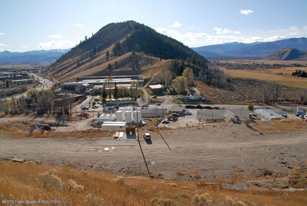
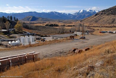
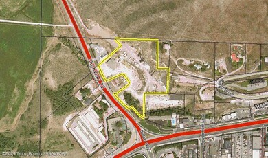
Commercial property located at the Y intersection. Zoned AC. Many potential opportunities.

Last Agent to Sell the Property

Tom Evans

Jackson Hole Sotheby's International Realty License #1487 Listed on: 12/11/2012

Last Buyer's Agent

Tom Evans

Jackson Hole Sotheby's International Realty License #1487 Listed on: 12/11/2012

Property Details

Property Type

  • Land

Est. Annual Taxes

  • $18,065

Lot Details

  • 6.76 Acre Lot
  • Year Round Access
  • Steep Slope
  • Zoning described as Commercial

Property Views

  • Mountain
  • Valley

Location

  • Property is near a forest

Utilities

  • Electricity To Lot Line
  • Phone Available

Community Details

  • No Home Owners Association

Listing and Financial Details

  • Assessor Parcel Number 22-41-16-32-1-00-009

Property Details

Property Type

Land

Est. Annual Taxes

$18,065

Lot Details

0

Listing Details

  • Prop. Type: Building Site
  • Horses: No
  • Lot Size Acres: 6.76
  • Road Surface Type: Paved
  • Subdivision Name: None
  • Directions: Just north of Albertsons and on the east side of Highway 22 going out of town.
  • Property Info:Horses Allowed: No
  • Property Features:Year Round Access: Yes
  • View:Mountain View: Yes
  • View:Valley View: Yes
  • Sale Status:Potential Short Sale: No
  • Property Features:Electric to Property: Yes
  • Property Features:Phone to Lot Line: Yes
  • Property Features:Steep: Yes
  • Water:Public: Yes
  • Sewer:Public2: Yes
  • Property Features:Forest Access: Yes
  • Special Features: None
  • Property Sub Type: LotsLands

Exterior Features

  • Lot Features: Year Round Access, Forest Access, Steep Slope
  • View: Mountain(s), Valley

Utilities

  • Electricity On Property: Yes
  • Sewer: Public Sewer
  • Utilities: Phone to Lot Line
  • Water Source: Public

Condo/Co-op/Association

  • Association: No

Lot Info

  • Lot Size Sq Ft: 294465.6
  • Parcel #: 22-41-16-32-1-00-009
  • Zoning Description: Commercial
  • ResoLotSizeUnits: Acres

Tax Info

  • Tax Annual Amount: 18064.54
  • Tax Year: 2010

Ownership History

Date Name Owned For Owner Type

Purchase Details

Closed on
Dec 9, 2021
Sold by
Waybroad Llc
Bought by
Overland West Inc
Source: Public Records

Range of Values:

--
Value Increase
--
Percent Increase
--
Adjusted for Inflation
Collateral Analytics

Collateral Analytics Collateral Analytics AVMs (Automated Valuation Model) employ a number of statistical approaches combined with neighborhood-specific comparable selection guarantees the most up-to-date and precise valuations.

Not Available

Collateral Analytics does not have data for the current month. Please view the chart for historical values.

ICE

ICE Mortgage Technology ICE Mortgage Technology’s AVM (Automated Valuation Model) is a state-of-the-art online residential property valuation tool that provides a quick and accurate estimate of the value of almost any home in the U.S.

Not Available

ICE Mortgage Technology does not have data for the current month. Please view the chart for historical values.

First American

First American First American Data & Analytics’ next-generation AVM combines unrivaled data assets with a blended ensemble of valuation models to produce highly accurate, reliable valuations you can trust.

Not Available

First American does not have data for the current month. Please view the chart for historical values.

Quantarium

Quantarium Quantarium’s valuation service, repeatedly proven the industry’s most accurate and comprehensive, is supercharged with a self-learning and auto-tuning AI engine that continually becomes smarter and more accurate as it processes daily inputs from the industry’s leading RE data lake.

Not Available

Quantarium does not have data for the current month. Please view the chart for historical values.

Average Value
Not Available
List Price
Sold Price
Create a Home Valuation Report for This Property
The Home Valuation Report is an in-depth analysis detailing your home's value as well as a comparison with similar homes in the area

Home Values in the Area

Source: Public Records

Average Home Value in this Area


Source: Public Records

Purchase History

Date Buyer Sale Price Title Company
Overland West Inc -- Wyoming Title & Escrow
Source: Public Records

Property History

Date Event Price List to Sale Price per Sq Ft
02/12/2013 02/12/13 Sold -- -- --
01/11/2013 01/11/13 Pending -- -- --
12/17/2007 12/17/07 For Sale $7,500,000 -- --
Source: Teton Board of REALTORS®

Tax History Compared to Growth

Source: Public Records

Tax History

Year Tax Paid Tax Assessment Tax Assessment Total Assessment is a certain percentage of the fair market value that is determined by local assessors to be the total taxable value of land and additions on the property. Land Improvement
2025 $52,638 $938,304 $759,131 $179,173
2024 $50,695 $901,573 $716,051 $185,522
2023 $84,132 $1,496,234 $1,181,019 $315,215
2022 $80,838 $1,444,083 $1,181,019 $263,064
2021 $35,137 $616,663 $464,968 $151,695
2020 $34,353 $613,685 $464,968 $148,717
2019 $32,453 $568,806 $464,968 $103,838
2018 $28,670 $505,158 $464,968 $40,190
2017 $19,293 $332,904 $303,619 $29,285
2016 $19,155 $330,519 $303,619 $26,900
2015 $17,643 $329,353 $303,619 $25,734
2014 $17,643 $304,950 $303,619 $1,331
2013 $17,643 $304,950 $303,619 $1,331
Source: Public Records

Agents Affiliated with this Home

  • Section Image
See All Agents

Map

Source: Teton Board of REALTORS®

MLS Number: 07-5555

APN: R0004663