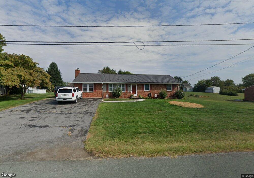
12250 Malissa Dr Greencastle, PA 17225
Estimated Value: $128,800 - $294,000
--
Bed
1
Bath
1,392
Sq Ft
$171/Sq Ft
Est. Value
About This Home
This home is located at 12250 Malissa Dr, Greencastle, PA 17225 and is currently estimated at $237,950, approximately $170 per square foot. 12250 Malissa Dr is a home located in Franklin County with nearby schools including Greencastle-Antrim Primary School, Greencastle-Antrim Elementary School, and Greencastle-Antrim Middle School.
Ownership History
Date
Name
Owned For
Owner Type
Purchase Details
Closed on
Dec 13, 2012
Sold by
Reeder Carole M and Miller Gregory L
Bought by
Miller Mark G
Current Estimated Value
Home Financials for this Owner
Home Financials are based on the most recent Mortgage that was taken out on this home.
Original Mortgage
$136,734
Outstanding Balance
$94,645
Interest Rate
3.35%
Mortgage Type
New Conventional
Estimated Equity
$143,305
Create a Home Valuation Report for This Property
The Home Valuation Report is an in-depth analysis detailing your home's value as well as a comparison with similar homes in the area
Home Values in the Area
Average Home Value in this Area
Purchase History
| Date | Buyer | Sale Price | Title Company |
|---|---|---|---|
| Miller Mark G | $134,000 | None Available |
Source: Public Records
Mortgage History
| Date | Status | Borrower | Loan Amount |
|---|---|---|---|
| Open | Miller Mark G | $136,734 |
Source: Public Records
Tax History Compared to Growth
Tax History
| Year | Tax Paid | Tax Assessment Tax Assessment Total Assessment is a certain percentage of the fair market value that is determined by local assessors to be the total taxable value of land and additions on the property. | Land | Improvement |
|---|---|---|---|---|
| 2025 | $2,777 | $16,600 | $1,420 | $15,180 |
| 2024 | $2,519 | $16,600 | $1,420 | $15,180 |
| 2023 | $2,490 | $16,600 | $1,420 | $15,180 |
| 2022 | $2,490 | $16,600 | $1,420 | $15,180 |
| 2021 | $2,441 | $16,600 | $1,420 | $15,180 |
| 2020 | $2,378 | $16,600 | $1,420 | $15,180 |
| 2019 | $2,324 | $16,600 | $1,420 | $15,180 |
| 2018 | $2,299 | $16,600 | $1,420 | $15,180 |
| 2017 | $2,241 | $16,600 | $1,420 | $15,180 |
| 2016 | $476 | $16,600 | $1,420 | $15,180 |
| 2015 | $443 | $16,600 | $1,420 | $15,180 |
| 2014 | $443 | $16,600 | $1,420 | $15,180 |
Source: Public Records
Map
Nearby Homes
- 12976 Daybreak Ln
- 12689 Williamsport Pike
- 10135 Jasper Dr
- 763 Joy Dr
- 11765 Melrose Ave
- 20 Helens Dr
- 707 Shook Ct W
- 281 Toms Ln
- 10937 Grant Shook Rd
- 10925 Grant Shook Rd
- 1223 E Pebblebrook Dr
- 11498 Nicole Dr
- 0 Molly Pitcher Hwy Unit PAFL178468
- 0 Molly Pitcher Hwy Unit PAFL2030380
- 642 Milnor Rd
- 2428 Pikeside Dr
- 480 S Carlisle St
- 375 Carolle St
- 775 Lohman Ave
- 34.77 Acres Red Oak Estate S
- 12224 Malissa Dr
- 12264 Malissa Dr
- 12263 Williamsport Pike
- 12237 Williamsport Pike
- 12227 Williamsport Pike
- 12188 Malissa Dr
- 12237 Malissa Dr
- 12270 Malissa Dr
- 12227 & 12217 Williamsport Pike
- 12281 Williamsport Pike
- 12251 Malissa Dr
- 12209 Williamsport Pike
- 12209,12211,12227 & Williamsport Pike
- 12170 Malissa Dr
- 12267 Malissa Dr
- 12303 Williamsport Pike
- 12290 Malissa Dr
- 1281 Brenda Dr
- 12197 Williamsport Pike
- 12299 Malissa Dr