Estimated Value: $143,332 - $171,000
3
Beds
1
Bath
1,206
Sq Ft
$130/Sq Ft
Est. Value
About This Home
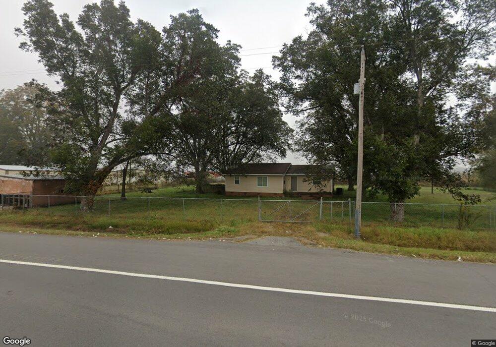
This home is located at 12258 Highway 165 W, Scott, AR 72142 and is currently estimated at $156,444, approximately $129 per square foot. 12258 Highway 165 W is a home located in Lonoke County with nearby schools including Harris Elementary School, Mills University Studies High School, and Scott Charter School.
Ownership History
Date
Name
Owned For
Owner Type
Purchase Details
Closed on
Aug 15, 2020
Sold by
Goepfert Michelle Marie and Johnston Michelle
Bought by
Johnston Michelle and Johnston Edward
Current Estimated Value
Home Financials for this Owner
Home Financials are based on the most recent Mortgage that was taken out on this home.
Original Mortgage
$46,000
Outstanding Balance
$40,805
Interest Rate
3%
Mortgage Type
New Conventional
Estimated Equity
$115,639
Purchase Details
Closed on
Nov 14, 2005
Bought by
Goepfert
Create a Home Valuation Report for This Property
The Home Valuation Report is an in-depth analysis detailing your home's value as well as a comparison with similar homes in the area
Purchase History
| Date | Buyer | Sale Price | Title Company |
|---|---|---|---|
| Johnston Michelle | -- | None Available | |
| Goepfert | $65,000 | -- |
Source: Public Records
Mortgage History
| Date | Status | Borrower | Loan Amount |
|---|---|---|---|
| Open | Johnston Michelle | $46,000 |
Source: Public Records
Tax History
| Year | Tax Paid | Tax Assessment Tax Assessment Total Assessment is a certain percentage of the fair market value that is determined by local assessors to be the total taxable value of land and additions on the property. | Land | Improvement |
|---|---|---|---|---|
| 2025 | $701 | $14,880 | $3,960 | $10,920 |
| 2024 | $701 | $14,880 | $3,960 | $10,920 |
| 2023 | $701 | $14,880 | $3,960 | $10,920 |
| 2022 | $701 | $14,880 | $3,960 | $10,920 |
| 2021 | $701 | $14,880 | $3,960 | $10,920 |
| 2020 | $282 | $13,940 | $3,860 | $10,080 |
| 2019 | $282 | $13,940 | $3,860 | $10,080 |
| 2018 | $307 | $13,940 | $3,860 | $10,080 |
| 2017 | $646 | $13,940 | $3,860 | $10,080 |
| 2016 | $296 | $13,940 | $3,860 | $10,080 |
| 2015 | $591 | $13,230 | $3,430 | $9,800 |
| 2014 | $241 | $13,230 | $3,430 | $9,800 |
Source: Public Records
Map
Nearby Homes
- 10642 Hwy 165 W
- 00 Upper Steel Bend Rd
- 14420 Upper Steel Bend Rd
- 13423 Smarty Jones Dr
- 13129 Smarty Jones Dr
- 000 Planters Row
- 00 Planters Row
- 53 Planters Row
- 13319 Smarty Jones Dr
- 12904 Smarty Jones Dr
- Old Highway 30
- 13203 Old River Dr
- 130 Ac Hwy 165 W
- 13118 Old River Dr
- 1070 Mound View Dr
- XX Colonel Maynard Rd
- 294 Ac Hwy 165 W
- 0 Colonel Maynard Rd Unit 26005250
- 0 Colonel Maynard Rd Unit 26005254
- 0 Colonel Maynard Rd Unit 26005249
- 12332 Highway 165 W
- 11906 Highway 165 W
- 11844 Highway 165 W
- 11844 W Hwy 165
- 11802 Highway 165 W
- 0 Tr5 Plantation Lake Dr
- 00 Bearskin Lake Loop
- Tract 1D Plantation Lake Rd
- 0 165 Hwy Unit 19013892
- 165 Highway
- W Hwy 165
- Tract B Planters Row
- Tract A Planters Row
- Tr 1-C Planation Lake Dr
- 00 Walter Estes Rd Rd
- 00 Holmes Rd
- E Bethany Rd
- 00 E Bethany Rd
- Lot 295 Smarty Jones Estates
- 0 Plantation Lake Dr Unit 20037926
Your Personal Tour Guide
Ask me questions while you tour the home.