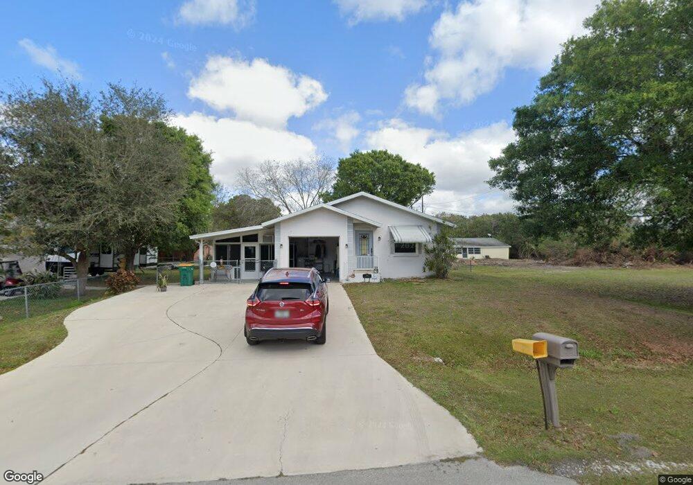
1226 Edmund St Punta Gorda, FL 33950
Central Punta Gorda NeighborhoodEstimated Value: $169,000 - $329,000
2
Beds
2
Baths
952
Sq Ft
$274/Sq Ft
Est. Value
About This Home
This home is located at 1226 Edmund St, Punta Gorda, FL 33950 and is currently estimated at $261,251, approximately $274 per square foot. 1226 Edmund St is a home located in Charlotte County with nearby schools including Sallie Jones Elementary School, Punta Gorda Middle School, and Charlotte High School.
Ownership History
Date
Name
Owned For
Owner Type
Purchase Details
Closed on
Nov 6, 2014
Sold by
Hale Linda L
Bought by
Hale Dennis James and Hale Linda L
Current Estimated Value
Purchase Details
Closed on
Dec 15, 2005
Sold by
Hale Linda L and Hale Dennis J
Bought by
Hale Linda L
Purchase Details
Closed on
May 19, 1997
Sold by
Burris Richard R and Burris Joyce L
Bought by
Burris Linda L
Home Financials for this Owner
Home Financials are based on the most recent Mortgage that was taken out on this home.
Original Mortgage
$45,000
Outstanding Balance
$6,254
Interest Rate
8.17%
Estimated Equity
$254,997
Create a Home Valuation Report for This Property
The Home Valuation Report is an in-depth analysis detailing your home's value as well as a comparison with similar homes in the area
Home Values in the Area
Average Home Value in this Area
Purchase History
| Date | Buyer | Sale Price | Title Company |
|---|---|---|---|
| Hale Dennis James | $8,200 | Attorney | |
| Hale Linda L | -- | Attorney | |
| Burris Linda L | -- | -- |
Source: Public Records
Mortgage History
| Date | Status | Borrower | Loan Amount |
|---|---|---|---|
| Open | Burris Linda L | $45,000 |
Source: Public Records
Tax History Compared to Growth
Tax History
| Year | Tax Paid | Tax Assessment Tax Assessment Total Assessment is a certain percentage of the fair market value that is determined by local assessors to be the total taxable value of land and additions on the property. | Land | Improvement |
|---|---|---|---|---|
| 2023 | $1,684 | $63,016 | $0 | $0 |
| 2022 | $1,604 | $61,181 | $0 | $0 |
| 2021 | $1,591 | $57,987 | $0 | $0 |
| 2020 | $1,536 | $57,186 | $0 | $0 |
| 2019 | $1,464 | $55,900 | $0 | $0 |
| 2018 | $1,376 | $54,858 | $0 | $0 |
| 2017 | $1,363 | $53,730 | $0 | $0 |
| 2016 | $1,347 | $51,687 | $0 | $0 |
| 2015 | $1,328 | $51,328 | $0 | $0 |
| 2014 | $1,049 | $50,921 | $0 | $0 |
Source: Public Records
Map
Nearby Homes
- 1105 Coral Ridge Dr
- 1226 Coral Ridge Dr
- 2620 Cooper St
- 541 Edmund St
- 2601 Lee St
- 2715 Lee St
- 2209 Cypress St
- 2739 Taylor Rd
- 2006 Cooper St
- 1308 Woodlawn Ave
- 10000 Tamiami Trail
- 7093 Mikasa Dr
- 2600 Jerry Ave
- 1210 Hickory Ave
- 1613 Woodlawn Ave
- 25008 Lalique Place
- 3800 Baynard Dr
- 3311 Areca St
- 3310 Ash St
- 2537 Carmen St Unit 31
- 1300 Edmund St
- 1210 Edmund St
- 1227 Ansin St
- 1211 Ansin St
- 1301 Ansin St
- 1200 Edmund St
- 1201 Ansin St
- 1126 Edmund St
- 1127 Ansin St
- 1125 Edmund St
- 2795 Lakeview Dr
- 1407 Coral Ridge Dr
- 1200 Coral Ridge Dr
- 935 Coral Ridge Dr
- 1422 Coral Ridge Dr
- 1409 Coral Ridge Dr
- 1130 Coral Ridge Dr
- 1417 Coral Ridge Dr
- 1411 Drive
- 1027 Coral Ridge Dr