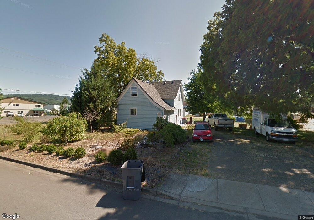
1226 W Main St Sheridan, OR 97378
Estimated Value: $334,000 - $363,222
3
Beds
2
Baths
1,380
Sq Ft
$256/Sq Ft
Est. Value
About This Home
This home is located at 1226 W Main St, Sheridan, OR 97378 and is currently estimated at $353,056, approximately $255 per square foot. 1226 W Main St is a home located in Yamhill County with nearby schools including Faulconer-Chapman School, Sheridan High School, and Sheridan Allprep Academy.
Ownership History
Date
Name
Owned For
Owner Type
Purchase Details
Closed on
Dec 6, 2011
Sold by
Martineau Richard G
Bought by
Martineau Richard G and Martineau Loretta W
Current Estimated Value
Purchase Details
Closed on
Dec 17, 2007
Sold by
Belanger Coreen Annette
Bought by
Martineau Richard Gordon
Purchase Details
Closed on
Dec 12, 2006
Sold by
Martineau Rick G
Bought by
Martineau Rick G and Martineau Coreene A
Purchase Details
Closed on
Nov 21, 2006
Sold by
Peterson Kathy P
Bought by
Martineau Rick G
Purchase Details
Closed on
Aug 18, 2006
Sold by
Coverdell Shawn E
Bought by
Martineau Rick G and Peterson Kathy G
Create a Home Valuation Report for This Property
The Home Valuation Report is an in-depth analysis detailing your home's value as well as a comparison with similar homes in the area
Home Values in the Area
Average Home Value in this Area
Purchase History
| Date | Buyer | Sale Price | Title Company |
|---|---|---|---|
| Martineau Richard G | -- | None Available | |
| Martineau Richard Gordon | -- | None Available | |
| Martineau Rick G | -- | First American Title | |
| Martineau Rick G | -- | First American Title | |
| Martineau Rick G | $145,000 | First American Title |
Source: Public Records
Tax History Compared to Growth
Tax History
| Year | Tax Paid | Tax Assessment Tax Assessment Total Assessment is a certain percentage of the fair market value that is determined by local assessors to be the total taxable value of land and additions on the property. | Land | Improvement |
|---|---|---|---|---|
| 2025 | $2,308 | $170,252 | -- | -- |
| 2024 | $2,119 | $165,293 | -- | -- |
| 2023 | $2,058 | $160,479 | $0 | $0 |
| 2022 | $2,001 | $155,805 | $0 | $0 |
| 2021 | $2,417 | $161,429 | $0 | $0 |
| 2020 | $1,781 | $119,524 | $0 | $0 |
| 2019 | $1,750 | $116,043 | $0 | $0 |
| 2018 | $1,700 | $112,663 | $0 | $0 |
| 2017 | $1,669 | $109,382 | $0 | $0 |
| 2016 | $1,557 | $106,196 | $0 | $0 |
| 2015 | $1,403 | $95,939 | $0 | $0 |
| 2014 | $1,447 | $98,799 | $0 | $0 |
Source: Public Records
Map
Nearby Homes
- 1315 W Main St
- 735 SW Mill St
- 0 NW Viola St
- 617 SW Monroe St
- 240 SW Jefferson St
- 370 NW Yamhill St
- 328 NW Sherman St
- 24550 SW Red Prairie Rd
- 240 NW Sagan Loop
- 18940 SW Canyon Rd
- 518 S Bridge St
- 119 NW Sherman St
- 21000 SW Canyon Rd
- 243 SE Harney St
- 740 SE Alicia St
- 24291 SW Rogers Rd
- 1200 Blk NE Center St Unit Parcel 4
- 25110 SW Red Prairie Rd
- 419 SE Sheridan Rd
- 0 NE Center St Unit 1 491349230
- 1210 W Main St
- 1280 NW Pacific Place
- 1295 NW Pacific Place
- 1305 NW Pacific Place
- 1241 W Main St
- 1310 NW Pacific Place
- 1320 NW Pacific Place
- 1315 NW Pacific Place
- 1168 W Main St
- 1330 W Main St
- 1330 W Main St Unit 3
- 1330 W Main St Unit 8
- 1145 W Main St
- 1135 W Main St
- 1341 W Main St
- 1111 W Main St
- 1360 W Main St
- 1103 W Main St
- 1054 W Main St
- 1430 W Main St