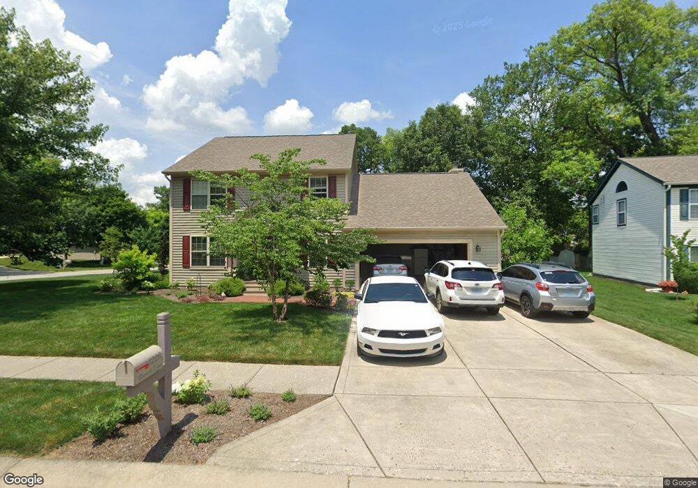
1228 Breaside Ct Greenwood, IN 46143
Estimated Value: $332,000 - $374,555
4
Beds
3
Baths
2,551
Sq Ft
$142/Sq Ft
Est. Value
About This Home
This home is located at 1228 Breaside Ct, Greenwood, IN 46143 and is currently estimated at $362,889, approximately $142 per square foot. 1228 Breaside Ct is a home located in Johnson County with nearby schools including Sugar Grove Elementary School, Center Grove Middle School North, and Center Grove High School.
Ownership History
Date
Name
Owned For
Owner Type
Purchase Details
Closed on
Aug 12, 2005
Sold by
Smith Todd E and Smith Kelly A
Bought by
Adams Douglas A and Adams Kathryn A
Current Estimated Value
Home Financials for this Owner
Home Financials are based on the most recent Mortgage that was taken out on this home.
Original Mortgage
$158,800
Outstanding Balance
$84,169
Interest Rate
5.8%
Mortgage Type
New Conventional
Estimated Equity
$278,720
Create a Home Valuation Report for This Property
The Home Valuation Report is an in-depth analysis detailing your home's value as well as a comparison with similar homes in the area
Home Values in the Area
Average Home Value in this Area
Purchase History
| Date | Buyer | Sale Price | Title Company |
|---|---|---|---|
| Adams Douglas A | -- | None Available |
Source: Public Records
Mortgage History
| Date | Status | Borrower | Loan Amount |
|---|---|---|---|
| Open | Adams Douglas A | $158,800 |
Source: Public Records
Tax History Compared to Growth
Tax History
| Year | Tax Paid | Tax Assessment Tax Assessment Total Assessment is a certain percentage of the fair market value that is determined by local assessors to be the total taxable value of land and additions on the property. | Land | Improvement |
|---|---|---|---|---|
| 2025 | $3,119 | $378,900 | $53,500 | $325,400 |
| 2024 | $3,119 | $311,900 | $53,500 | $258,400 |
| 2023 | $3,047 | $304,000 | $53,500 | $250,500 |
| 2022 | $2,681 | $268,100 | $48,100 | $220,000 |
| 2021 | $2,354 | $235,400 | $38,200 | $197,200 |
| 2020 | $2,211 | $221,100 | $38,200 | $182,900 |
| 2019 | $2,078 | $207,800 | $34,800 | $173,000 |
| 2018 | $1,968 | $209,100 | $34,800 | $174,300 |
| 2017 | $1,846 | $185,200 | $34,800 | $150,400 |
| 2016 | $1,787 | $185,900 | $45,900 | $140,000 |
| 2014 | $1,746 | $178,800 | $45,900 | $132,900 |
| 2013 | $1,746 | $180,300 | $45,900 | $134,400 |
Source: Public Records
Map
Nearby Homes
- 771 Burr Oak Dr
- 1119 Lazio Ct
- 859 Sheffield Dr
- 1216 Thornmeadow Cir
- 1179 Barrington Dr
- 1393 Padana Dr
- 1132 Veranda Ct
- Calvin Plan at Brighton Knoll - Designer Collection
- Blair Plan at Brighton Knoll - Designer Collection
- Avery Plan at Brighton Knoll - Designer Collection
- Charles Plan at Brighton Knoll - Designer Collection
- Wyatt Plan at Brighton Knoll - Designer Collection
- Winston Plan at Brighton Knoll - Designer Collection
- Emmett Plan at Brighton Knoll - Designer Collection
- Carrington Plan at Brighton Knoll - Designer Collection
- Grandin Plan at Brighton Knoll - Designer Collection
- 1509 Old Thicket Ct
- 1117 Sarah Ct
- 599 Yorktown Rd
- 497 S Hendricks Dr
- 1220 Breaside Ct
- 1214 Breaside Ct
- 932 Breaside Ln
- 1235 Black Oak Cir
- 1227 Black Oak Cir
- 944 Breaside Ln
- 920 Breaside Ln
- 1227 Breaside Ct
- 1219 Black Oak Cir
- 1219 Breaside Ct
- 956 Breaside Ln
- 1241 Black Oak Dr
- 1211 Black Oak Cir
- 898 Breaside Ln
- 1213 Breaside Ct
- 970 Breaside Ln
- 1249 Black Oak Dr
- 1222 Elm Grove Way
- 1021 Elm Grove Cir
- 1216 Elm Grove Way