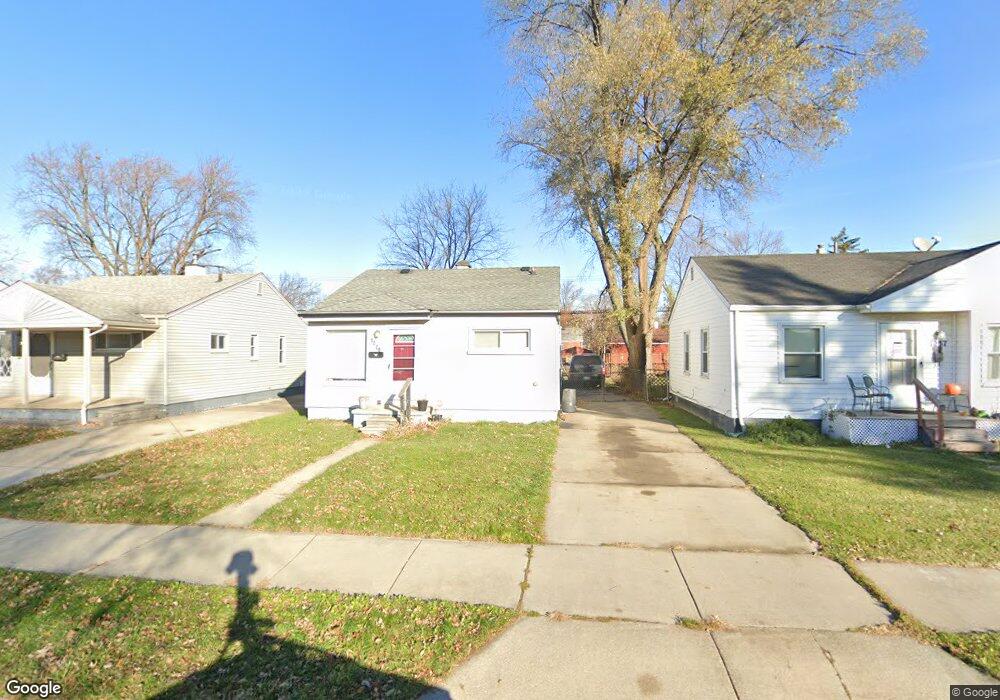
1229 E Rowland Ave Madison Heights, MI 48071
Estimated Value: $120,079 - $151,000
2
Beds
1
Bath
720
Sq Ft
$192/Sq Ft
Est. Value
About This Home
This home is located at 1229 E Rowland Ave, Madison Heights, MI 48071 and is currently estimated at $138,020, approximately $191 per square foot. 1229 E Rowland Ave is a home located in Oakland County with nearby schools including Madison High School and Michigan Mathematics and Science Academy Dequindre.
Ownership History
Date
Name
Owned For
Owner Type
Purchase Details
Closed on
Aug 25, 2009
Sold by
Murarescu Ioan and Murarescu Paraschiva
Bought by
Federal Home Loan Mortgage Corp
Current Estimated Value
Purchase Details
Closed on
Apr 24, 2000
Sold by
Wilt Gary
Bought by
Murarescu Ioan
Home Financials for this Owner
Home Financials are based on the most recent Mortgage that was taken out on this home.
Original Mortgage
$73,395
Interest Rate
8.14%
Purchase Details
Closed on
Jun 15, 1997
Sold by
Taub Peggy M
Bought by
Taub Gregory
Create a Home Valuation Report for This Property
The Home Valuation Report is an in-depth analysis detailing your home's value as well as a comparison with similar homes in the area
Home Values in the Area
Average Home Value in this Area
Purchase History
| Date | Buyer | Sale Price | Title Company |
|---|---|---|---|
| Federal Home Loan Mortgage Corp | $53,643 | None Available | |
| Murarescu Ioan | $74,000 | -- | |
| Taub Gregory | -- | -- |
Source: Public Records
Mortgage History
| Date | Status | Borrower | Loan Amount |
|---|---|---|---|
| Previous Owner | Murarescu Ioan | $73,395 |
Source: Public Records
Tax History
| Year | Tax Paid | Tax Assessment Tax Assessment Total Assessment is a certain percentage of the fair market value that is determined by local assessors to be the total taxable value of land and additions on the property. | Land | Improvement |
|---|---|---|---|---|
| 2025 | $1,119 | $53,440 | $0 | $0 |
| 2024 | $841 | $50,070 | $0 | $0 |
| 2023 | $806 | $45,170 | $0 | $0 |
| 2022 | $964 | $40,400 | $0 | $0 |
| 2021 | $937 | $35,040 | $0 | $0 |
| 2020 | $777 | $30,300 | $0 | $0 |
| 2019 | $960 | $27,210 | $0 | $0 |
| 2018 | $945 | $18,840 | $0 | $0 |
| 2017 | $920 | $18,840 | $0 | $0 |
| 2016 | $883 | $17,230 | $0 | $0 |
| 2015 | -- | $15,060 | $0 | $0 |
| 2014 | -- | $13,330 | $0 | $0 |
| 2011 | -- | $16,620 | $0 | $0 |
Source: Public Records
Map
Nearby Homes
- 1212 E Rowland Ave
- 975 E Barrett Ave
- 1166 E Kalama Ave
- 25747 Miracle Dr
- 5820 Heights Dr Unit 17 / Building 9
- 545 E Dallas Ave
- 644 E Brickley Ave
- 1202 Ann Terrace Unit Lot 125
- 1520 Christine Terrace Unit 65
- 1773 Ann Terrace Unit 248
- 26387 Alden St
- 26284 Tawas St
- 627 E Mapledale Ave
- 31 W Barrett Ave
- 45 W Hudson Ave
- 537 Andresen Ct
- 30 W Kalama Ave
- 26475 Lorenz St
- 103 W Dallas Ave
- 26644 Lorenz St
- 1221 E Rowland Ave
- 1237 E Rowland Ave
- 1245 E Rowland Ave
- 1220 E Barrett Ave
- 1228 E Barrett Ave Unit Bldg-Unit
- 1228 E Barrett Ave
- 1205 E Rowland Ave
- 1238 E Barrett Ave
- 1197 E Rowland Ave
- 1208 E Barrett Ave Unit Bldg-Unit
- 1208 E Barrett Ave
- 1248 E Barrett Ave
- 1253 E Rowland Ave
- 1220 E Rowland Ave
- 1236 E Rowland Ave
- 1228 E Rowland Ave
- 1263 E Rowland Ave
- 1198 E Barrett Ave
- 1204 E Rowland Ave
- 1260 E Barrett Ave