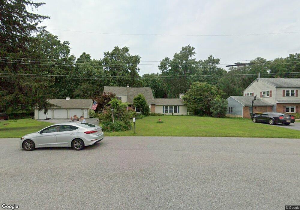
1229 Kay Cir West Chester, PA 19382
Estimated Value: $493,000 - $598,000
3
Beds
2
Baths
1,902
Sq Ft
$284/Sq Ft
Est. Value
About This Home
This home is located at 1229 Kay Cir, West Chester, PA 19382 and is currently estimated at $540,471, approximately $284 per square foot. 1229 Kay Cir is a home located in Chester County with nearby schools including Bradford Heights Elementary School, Downingtown Middle School, and Downingtown High School West.
Ownership History
Date
Name
Owned For
Owner Type
Purchase Details
Closed on
Jun 15, 2011
Sold by
Waughn Lorraine B
Bought by
Rhodes Lloyd and Rhodes Karin
Current Estimated Value
Home Financials for this Owner
Home Financials are based on the most recent Mortgage that was taken out on this home.
Original Mortgage
$231,200
Outstanding Balance
$160,205
Interest Rate
4.74%
Mortgage Type
New Conventional
Estimated Equity
$380,266
Purchase Details
Closed on
Nov 20, 2003
Sold by
Weiland Frank B and Weiland Valerie A
Bought by
Waughn William J and Waughn Lorraine B
Home Financials for this Owner
Home Financials are based on the most recent Mortgage that was taken out on this home.
Original Mortgage
$150,000
Interest Rate
5.98%
Mortgage Type
Purchase Money Mortgage
Create a Home Valuation Report for This Property
The Home Valuation Report is an in-depth analysis detailing your home's value as well as a comparison with similar homes in the area
Home Values in the Area
Average Home Value in this Area
Purchase History
| Date | Buyer | Sale Price | Title Company |
|---|---|---|---|
| Rhodes Lloyd | $289,000 | Commonwealth Land Title Insu | |
| Waughn William J | $199,000 | -- |
Source: Public Records
Mortgage History
| Date | Status | Borrower | Loan Amount |
|---|---|---|---|
| Open | Rhodes Lloyd | $231,200 | |
| Previous Owner | Waughn William J | $150,000 |
Source: Public Records
Tax History Compared to Growth
Tax History
| Year | Tax Paid | Tax Assessment Tax Assessment Total Assessment is a certain percentage of the fair market value that is determined by local assessors to be the total taxable value of land and additions on the property. | Land | Improvement |
|---|---|---|---|---|
| 2025 | $4,907 | $141,790 | $41,320 | $100,470 |
| 2024 | $4,907 | $141,790 | $41,320 | $100,470 |
| 2023 | $4,765 | $141,790 | $41,320 | $100,470 |
| 2022 | $4,647 | $141,790 | $41,320 | $100,470 |
| 2021 | $4,570 | $141,790 | $41,320 | $100,470 |
| 2020 | $4,545 | $141,790 | $41,320 | $100,470 |
| 2019 | $4,474 | $141,790 | $41,320 | $100,470 |
| 2018 | $4,474 | $141,790 | $41,320 | $100,470 |
| 2017 | $4,474 | $141,790 | $41,320 | $100,470 |
| 2016 | $4,148 | $141,790 | $41,320 | $100,470 |
| 2015 | $4,148 | $141,790 | $41,320 | $100,470 |
| 2014 | $4,148 | $141,790 | $41,320 | $100,470 |
Source: Public Records
Map
Nearby Homes
- 621 Sugars Bridge Rd
- 556 Cann Rd
- 547 Northbrook Rd
- 1114 Bordley Ln
- 409 N Wawaset Rd
- 950 Sugars Bridge Rd
- 1444 Telegraph Rd
- 1484 W Strasburg Rd
- 1223 Hall Rd
- 1052 Appleville Rd
- 1337 Carolannes Way Unit B3
- 1339 Carolannes Way Unit B3
- 1339 Carolannes Way Unit NT
- 1339 Carolannes Way Unit B4
- 1339 Carolannes Way Unit B6
- 1339 Carolannes Way Unit B1
- 10 Trimbles Ford Ln
- 1236 Shadyside Rd
- 1300 Shadyside Rd
- 1342 Carolannes Way