Estimated Value: $65,329 - $194,000
--
Bed
1
Bath
1,032
Sq Ft
$138/Sq Ft
Est. Value
About This Home
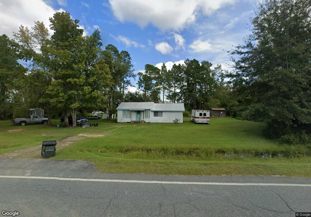
This home is located at 12292 Lanes Bridge Rd, Odum, GA 31555 and is currently estimated at $142,332, approximately $137 per square foot. 12292 Lanes Bridge Rd is a home located in Wayne County with nearby schools including Odum Elementary School, Martha Puckett Middle School, and Wayne County High School.
Ownership History
Date
Name
Owned For
Owner Type
Purchase Details
Closed on
Apr 1, 2020
Sold by
Rogers Eunita E
Bought by
Rogers Rental Properties Llc
Current Estimated Value
Purchase Details
Closed on
Aug 22, 2013
Sold by
Edenfield Willie J
Bought by
Edenfield James Kary and Rogers Eunita E
Purchase Details
Closed on
Jun 1, 2006
Sold by
Mercer Cecilia Gravely
Bought by
Edenfield W J
Purchase Details
Closed on
Feb 20, 2006
Sold by
Gravley Johnny W
Bought by
Gravley Charles Lamar
Purchase Details
Closed on
Mar 1, 2000
Purchase Details
Closed on
Feb 1, 2000
Purchase Details
Closed on
Jul 1, 1984
Create a Home Valuation Report for This Property
The Home Valuation Report is an in-depth analysis detailing your home's value as well as a comparison with similar homes in the area
Home Values in the Area
Average Home Value in this Area
Purchase History
| Date | Buyer | Sale Price | Title Company |
|---|---|---|---|
| Rogers Rental Properties Llc | -- | -- | |
| Edenfield James Kary | -- | -- | |
| Edenfield W J | $18,500 | -- | |
| Gravley Charles Lamar | -- | -- | |
| -- | -- | -- | |
| -- | $2,000 | -- | |
| -- | -- | -- |
Source: Public Records
Tax History Compared to Growth
Tax History
| Year | Tax Paid | Tax Assessment Tax Assessment Total Assessment is a certain percentage of the fair market value that is determined by local assessors to be the total taxable value of land and additions on the property. | Land | Improvement |
|---|---|---|---|---|
| 2024 | $571 | $21,558 | $494 | $21,064 |
| 2023 | $556 | $18,930 | $494 | $18,436 |
| 2022 | $480 | $15,251 | $494 | $14,757 |
| 2021 | $434 | $12,874 | $494 | $12,380 |
| 2020 | $522 | $14,955 | $2,575 | $12,380 |
| 2019 | $537 | $14,955 | $2,575 | $12,380 |
| 2018 | $537 | $14,955 | $2,575 | $12,380 |
| 2017 | $462 | $14,955 | $2,575 | $12,380 |
| 2016 | $448 | $14,955 | $2,575 | $12,380 |
| 2014 | $449 | $14,955 | $2,575 | $12,380 |
| 2013 | -- | $14,954 | $2,575 | $12,379 |
Source: Public Records
Map
Nearby Homes
- Morris Break Rd
- Morris Break Rd
- Morris Break Rd
- 11235 Lanes Bridge Rd
- 92 Sparrow Ln
- 192 Hummingbird Ln
- 300 Three C Rd
- 272 Three C Rd
- 236 Three C Rd
- 128 Three C Rd
- 330 Troy Pearson Rd
- 17380 Lanes Bridge Rd
- 17614 Lanes Bridge Rd
- 239 Troy Pearson Rd
- 0 Old River Rd Unit 10329316
- 88 Northshore Ave
- 192 Northshore Ave
- 200 Northshore Ave
- 177 Northshore Ave
- 2936 Madray Springs Rd
- 31 Mallard and Pye Rd
- 12135 Lanes Bridge Rd
- 12262 Lanes Bridge Rd
- 12105 Lanes Bridge Rd
- 12005 Lanes Bridge Rd
- 11969 Lanes Bridge Rd
- 391 New Hope Rd
- 370 Mallard and Pye Rd
- 115 New Hope Rd
- 7854 Beards Bluff Rd
- 12849 Lanes Bridge Rd
- 7850 Beards Bluff Rd
- 7777 Beards Bluff Rd
- 11645 Lanes Bridge Rd
- 663 Mallard and Pye Rd
- 249 Brunner Farm Rd
- 11495 Lanes Bridge Rd
- 11601 Lanes Bridge Rd
- 776 New Hope Rd
- 824 New Hope Rd