Estimated Value: $251,848 - $261,000
3
Beds
2
Baths
1,023
Sq Ft
$251/Sq Ft
Est. Value
About This Home
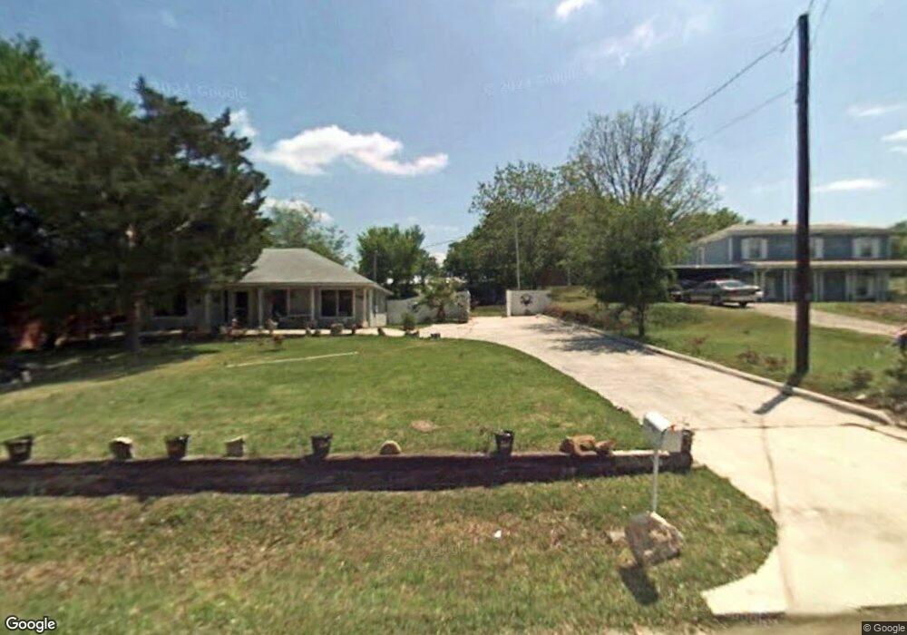
This home is located at 123 Brookshire Ave, Azle, TX 76020 and is currently estimated at $256,424, approximately $250 per square foot. 123 Brookshire Ave is a home located in Tarrant County with nearby schools including Azle Elementary School, Azle Junior High School, and Azle High School.
Ownership History
Date
Name
Owned For
Owner Type
Purchase Details
Closed on
Apr 9, 2009
Sold by
Harmony Hill
Bought by
Ainslie David R and David R Ainslie Living Trust
Current Estimated Value
Purchase Details
Closed on
Mar 29, 2005
Sold by
Ainslie David R
Bought by
Ainslie David R and The David R Ainslie Living Trust
Purchase Details
Closed on
Nov 11, 1999
Sold by
Wilson Paul K and Wilson Joey
Bought by
Ainsley David R
Home Financials for this Owner
Home Financials are based on the most recent Mortgage that was taken out on this home.
Original Mortgage
$40,000
Interest Rate
7.83%
Create a Home Valuation Report for This Property
The Home Valuation Report is an in-depth analysis detailing your home's value as well as a comparison with similar homes in the area
Home Values in the Area
Average Home Value in this Area
Purchase History
| Date | Buyer | Sale Price | Title Company |
|---|---|---|---|
| Ainslie David R | -- | Fidelity National Title | |
| Ainslie David R | -- | -- | |
| Ainsley David R | -- | Safeco Land Title |
Source: Public Records
Mortgage History
| Date | Status | Borrower | Loan Amount |
|---|---|---|---|
| Previous Owner | Ainsley David R | $40,000 |
Source: Public Records
Tax History Compared to Growth
Tax History
| Year | Tax Paid | Tax Assessment Tax Assessment Total Assessment is a certain percentage of the fair market value that is determined by local assessors to be the total taxable value of land and additions on the property. | Land | Improvement |
|---|---|---|---|---|
| 2025 | $1,866 | $217,000 | $75,362 | $141,638 |
| 2024 | $1,866 | $241,217 | $75,362 | $165,855 |
| 2023 | $2,951 | $228,576 | $75,362 | $153,214 |
| 2022 | $3,085 | $189,324 | $35,361 | $153,963 |
| 2021 | $2,899 | $161,147 | $35,361 | $125,786 |
| 2020 | $2,635 | $131,254 | $18,344 | $112,910 |
| 2019 | $2,480 | $95,000 | $18,344 | $76,656 |
| 2018 | $2,073 | $92,105 | $18,344 | $73,761 |
| 2017 | $2,117 | $86,699 | $18,344 | $68,355 |
| 2016 | $1,925 | $89,268 | $18,344 | $70,924 |
| 2015 | $1,572 | $69,200 | $10,000 | $59,200 |
| 2014 | $1,572 | $69,200 | $10,000 | $59,200 |
Source: Public Records
Map
Nearby Homes
- 1508 Red Oak Cir
- 1320 Craft Farms Cir
- 112 Ty Ln
- 432 Wilshire Ave
- 120 Timberlake Dr
- 1716 Southeast Pkwy
- 428 Wilshire Ave
- 205 Oregon Ave
- 1617 Florence Dr
- 233 Victoria Ave
- 372 Shoreline Dr
- 217 Ridgeway Ave
- 117 Redbird Ln N
- 356 Shoreline Dr
- 1907 Live Oak Cir
- 409 Corriente Trail
- 305 Familia Ct
- 100 Valle Ct
- 300 Shoreline Dr
- 321 Timberlake Dr
- 119 Brookshire Ave
- 127 Brookshire Ave
- 122 Brookshire Ave
- 130 Brookshire Ave
- 135 Brookshire Ave
- 139 Brookshire Ave
- 134 Brookshire Ave
- 106 Brookshire Ave
- 100 Normandy Ave
- 103 Brookshire Ave
- 1512 Southeast Pkwy
- 2016 Forest Bluff Trail
- 2024 Forest Bluff Trail
- 2008 Forest Bluff Trail
- 2004 Forest Bluff Trail
- 147 Brookshire Ave
- 103 Normandy Ave
- 121 Normandy Ave
- 117 Normandy Ave
- 101 Brookshire Ave