
Seller's Agent in 2025
Carol Martino
Coldwell Banker Realty - Lynnfield
(781) 426-5886
1 in this area
12 Total Sales
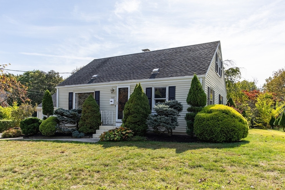


This classic Cape-Cod home combines timeless character with everyday comfort. The first floor showcases hardwood floors throughout the living room and two bedrooms, along with sliding glass doors that lead to a welcoming sitting area — the perfect spot to enjoy your morning coffee or relax on warm summer evenings. Upstairs, you’ll find two more spacious bedrooms with gleaming hardwood floors, offering both comfort and flexibility. The full-size basement provides endless possibilities — whether you imagine extra living space, a playroom, home office, or simply clean, organized storage. A convenient heated all-season porch is attached to both the house and garage, adding versatile space and enhancing everyday living. Recent updates include a new heating system, hot water heater, 200-amp full copper electrical service, and central air conditioning — ensuring comfort, efficiency, and peace of mind for years to come.
Last Agent to Sell the Property
Coldwell Banker Realty - Lynnfield Listed on: 10/02/2025
| Date | Type | Sale Price | Title Company |
|---|---|---|---|
| Quit Claim Deed | $640,000 | -- | |
| Deed | -- | -- | |
| Deed | $133,000 | -- |
| Date | Status | Loan Amount | Loan Type |
|---|---|---|---|
| Open | $576,000 | New Conventional | |
| Previous Owner | $47,000 | No Value Available | |
| Previous Owner | $45,000 | Purchase Money Mortgage |
| Date | Event | Price | List to Sale | Price per Sq Ft |
|---|---|---|---|---|
| 11/06/2025 11/06/25 | Sold | $640,000 | +10.5% | $464 / Sq Ft |
| 10/07/2025 10/07/25 | Pending | -- | -- | -- |
| 10/02/2025 10/02/25 | For Sale | $579,000 | -- | $420 / Sq Ft |
| Year | Tax Paid | Tax Assessment Tax Assessment Total Assessment is a certain percentage of the fair market value that is determined by local assessors to be the total taxable value of land and additions on the property. | Land | Improvement |
|---|---|---|---|---|
| 2025 | $5,810 | $528,700 | $332,500 | $196,200 |
| 2024 | $5,758 | $518,300 | $332,500 | $185,800 |
| 2023 | $5,318 | $452,600 | $285,000 | $167,600 |
| 2022 | $5,192 | $410,100 | $249,400 | $160,700 |
| 2021 | $4,586 | $343,500 | $204,300 | $139,200 |
| 2020 | $4,486 | $343,500 | $204,300 | $139,200 |
| 2019 | $4,657 | $350,700 | $213,800 | $136,900 |
| 2018 | $4,536 | $335,000 | $211,400 | $123,600 |
| 2017 | $4,571 | $322,100 | $205,400 | $116,700 |
| 2016 | $4,391 | $309,200 | $195,900 | $113,300 |
| 2015 | $4,293 | $287,900 | $178,100 | $109,800 |
Seller's Agent in 2025
Carol Martino
Coldwell Banker Realty - Lynnfield
(781) 426-5886
1 in this area
12 Total Sales
Buyer's Agent in 2025
Tom Barcikowski
Oakmont Real Estate LLC
(781) 710-8423
2 in this area
28 Total Sales
Source: MLS Property Information Network (MLS PIN)
MLS Number: 73433192
APN: DANV-000045-000000-000058
Disclaimer: Certain information contained herein is derived from information provided by parties other than Homes.com. All information provided is deemed reliable, but is not guaranteed to be accurate and should be independently verified.
![]() The property listing data and information, or the Images, set forth herein were provided to MLS Property Information Network, Inc. from third party sources, including sellers, lessors and public records, and were compiled by MLS Property Information Network, Inc. The property listing data and information, and the Images, are for the personal, non-commercial use of consumers having a good faith interest in purchasing or leasing listed properties of the type displayed to them and may not be used for any purpose other than to identify prospective properties which such consumers may have a good faith interest in purchasing or leasing. MLS Property Information Network, Inc. and its subscribers disclaim any and all representations and warranties as to the accuracy of the property listing data and information, or as to the accuracy of any of the Images, set forth herein.
The property listing data and information, or the Images, set forth herein were provided to MLS Property Information Network, Inc. from third party sources, including sellers, lessors and public records, and were compiled by MLS Property Information Network, Inc. The property listing data and information, and the Images, are for the personal, non-commercial use of consumers having a good faith interest in purchasing or leasing listed properties of the type displayed to them and may not be used for any purpose other than to identify prospective properties which such consumers may have a good faith interest in purchasing or leasing. MLS Property Information Network, Inc. and its subscribers disclaim any and all representations and warranties as to the accuracy of the property listing data and information, or as to the accuracy of any of the Images, set forth herein.
Ask me questions while you tour the home.