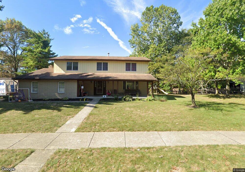
123 Daniel Dr Westerville, OH 43081
Estimated Value: $437,957 - $470,000
4
Beds
3
Baths
2,406
Sq Ft
$189/Sq Ft
Est. Value
About This Home
This home is located at 123 Daniel Dr, Westerville, OH 43081 and is currently estimated at $454,989, approximately $189 per square foot. 123 Daniel Dr is a home located in Franklin County with nearby schools including Mark Twain Elementary School, Walnut Springs Middle School, and Westerville-North High School.
Ownership History
Date
Name
Owned For
Owner Type
Purchase Details
Closed on
Jan 27, 2003
Sold by
Shaeffer Rebecca S
Bought by
Speed John K and Speed Anetta C
Current Estimated Value
Home Financials for this Owner
Home Financials are based on the most recent Mortgage that was taken out on this home.
Original Mortgage
$168,000
Outstanding Balance
$69,299
Interest Rate
5.94%
Estimated Equity
$385,690
Purchase Details
Closed on
Feb 23, 2000
Sold by
Gossett Joe W and Gossett Patricia A
Bought by
Shaeffer Rebecca S
Home Financials for this Owner
Home Financials are based on the most recent Mortgage that was taken out on this home.
Original Mortgage
$138,000
Interest Rate
8.9%
Purchase Details
Closed on
May 15, 1970
Bought by
Gossett Joe W
Create a Home Valuation Report for This Property
The Home Valuation Report is an in-depth analysis detailing your home's value as well as a comparison with similar homes in the area
Home Values in the Area
Average Home Value in this Area
Purchase History
| Date | Buyer | Sale Price | Title Company |
|---|---|---|---|
| Speed John K | $168,000 | -- | |
| Shaeffer Rebecca S | $135,000 | Title First Agency Inc | |
| Gossett Joe W | -- | -- |
Source: Public Records
Mortgage History
| Date | Status | Borrower | Loan Amount |
|---|---|---|---|
| Open | Speed John K | $168,000 | |
| Closed | Shaeffer Rebecca S | $138,000 |
Source: Public Records
Tax History
| Year | Tax Paid | Tax Assessment Tax Assessment Total Assessment is a certain percentage of the fair market value that is determined by local assessors to be the total taxable value of land and additions on the property. | Land | Improvement |
|---|---|---|---|---|
| 2025 | $7,002 | $123,200 | $33,250 | $89,950 |
| 2024 | $7,002 | $123,200 | $33,250 | $89,950 |
| 2023 | $7,125 | $123,200 | $33,250 | $89,950 |
| 2022 | $7,248 | $95,760 | $15,750 | $80,010 |
| 2021 | $7,307 | $95,760 | $15,750 | $80,010 |
| 2020 | $7,287 | $95,760 | $15,750 | $80,010 |
| 2019 | $5,897 | $72,490 | $15,750 | $56,740 |
| 2018 | $5,570 | $72,490 | $15,750 | $56,740 |
| 2017 | $5,670 | $72,490 | $15,750 | $56,740 |
| 2016 | $5,808 | $69,270 | $19,290 | $49,980 |
| 2015 | $5,625 | $69,270 | $19,290 | $49,980 |
| 2014 | $5,629 | $69,270 | $19,290 | $49,980 |
| 2013 | $2,677 | $65,975 | $18,375 | $47,600 |
Source: Public Records
Map
Nearby Homes
- 687 E College Ave
- 629 Andrew Ave
- 961 E College Ave
- 291 Mohawk Ave
- 138 Wood St
- 852 Karen Ct
- 655 Mohican Way
- 487 Beachside Dr
- 328 Myrtle Dr Unit Lot 5
- 348 Myrtle Dr Unit Lot 10
- 337 Myrtle Dr Unit Lot 2
- 334 Myrtle Dr Unit Lot 7
- 342 Myrtle Dr Unit Lot 8
- 344 Myrtle Dr Unit Lot 9
- 392 Hickory Ln
- 133 Illinois Ave
- 960 Lakeland Dr
- 559 Allview Ct
- 45 Kanpur Place
- 612 E Schrock Rd
- 127 Patti Ct
- 121 Daniel Dr
- 120 Daniel Dr
- 603 Patricia Ann Ln
- 124 Daniel Dr
- 129 Patti Ct
- 116 Daniel Dr
- 135 Patti Dr
- 578 Woodlawn Ave
- 595 Patricia Ann Ln
- 131 Patti Ct
- 110 Daniel Dr
- 587 Patricia Ann Ln
- 128 Patti Dr
- 137 Patti Dr
- 604 Patricia Ann Ln
- 125 Debbie Dr
- 121 Debbie Dr
- 596 Patricia Ann Ln
- 577 Patricia Ann Ln
Your Personal Tour Guide
Ask me questions while you tour the home.