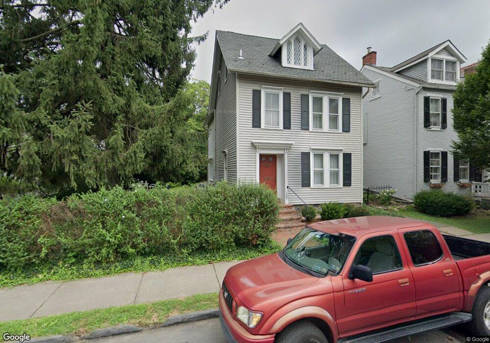
123 E Wall St Bethlehem, PA 18018
Downtown Bethlehem NeighborhoodEstimated Value: $333,000 - $565,000
3
Beds
2
Baths
1,680
Sq Ft
$259/Sq Ft
Est. Value
About This Home
This home is located at 123 E Wall St, Bethlehem, PA 18018 and is currently estimated at $434,553, approximately $258 per square foot. 123 E Wall St is a home located in Northampton County with nearby schools including Thomas Jefferson Elementary School, Northeast Middle School, and Liberty High School.
Ownership History
Date
Name
Owned For
Owner Type
Purchase Details
Closed on
Jun 6, 2005
Sold by
Sherman Ruthella
Bought by
Malseed Todd
Current Estimated Value
Home Financials for this Owner
Home Financials are based on the most recent Mortgage that was taken out on this home.
Original Mortgage
$320,480
Outstanding Balance
$167,633
Interest Rate
5.79%
Mortgage Type
New Conventional
Estimated Equity
$266,920
Purchase Details
Closed on
Apr 1, 1999
Bought by
Sherman Ruthella V Revocable
Create a Home Valuation Report for This Property
The Home Valuation Report is an in-depth analysis detailing your home's value as well as a comparison with similar homes in the area
Home Values in the Area
Average Home Value in this Area
Purchase History
| Date | Buyer | Sale Price | Title Company |
|---|---|---|---|
| Malseed Todd | $400,600 | -- | |
| Sherman Ruthella V Revocable | -- | -- |
Source: Public Records
Mortgage History
| Date | Status | Borrower | Loan Amount |
|---|---|---|---|
| Open | Malseed Todd | $320,480 |
Source: Public Records
Tax History
| Year | Tax Paid | Tax Assessment Tax Assessment Total Assessment is a certain percentage of the fair market value that is determined by local assessors to be the total taxable value of land and additions on the property. | Land | Improvement |
|---|---|---|---|---|
| 2025 | $677 | $62,700 | $28,900 | $33,800 |
| 2024 | $5,542 | $62,700 | $28,900 | $33,800 |
| 2023 | $5,542 | $62,700 | $28,900 | $33,800 |
| 2022 | $5,499 | $62,700 | $28,900 | $33,800 |
| 2021 | $5,462 | $62,700 | $28,900 | $33,800 |
| 2020 | $5,410 | $62,700 | $28,900 | $33,800 |
| 2019 | $5,392 | $62,700 | $28,900 | $33,800 |
| 2018 | $5,261 | $62,700 | $28,900 | $33,800 |
| 2017 | $5,198 | $62,700 | $28,900 | $33,800 |
| 2016 | -- | $62,700 | $28,900 | $33,800 |
| 2015 | -- | $62,700 | $28,900 | $33,800 |
| 2014 | -- | $62,700 | $28,900 | $33,800 |
Source: Public Records
Map
Nearby Homes
- 313 E Church St
- 212 E North St
- 48 E North St
- 123 E Garrison St
- 744 Center St
- 72 W Market St
- 38 W North St
- 211 E Goepp St
- 913 High St
- 829 N New St
- 15 W 2nd St
- 11 W 2nd St Unit 317
- 205 W Broad St
- 1037 Maple St
- 4311 Stonebridge Dr
- 612 E 5th St
- 412 Atlantic St
- 229 W Fairview St
- 451 Brighton St
- 515 E Laurel St
Your Personal Tour Guide
Ask me questions while you tour the home.