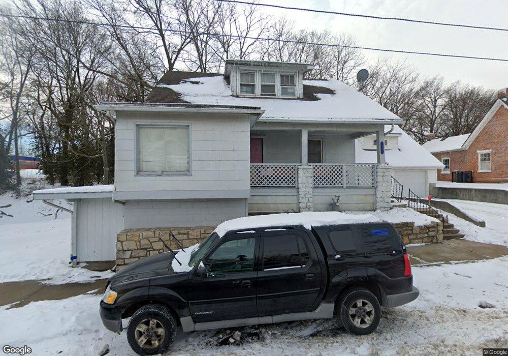
123 E Walnut St Independence, MO 64050
Heart of Independence NeighborhoodEstimated Value: $128,000 - $180,000
3
Beds
2
Baths
1,307
Sq Ft
$119/Sq Ft
Est. Value
About This Home
This home is located at 123 E Walnut St, Independence, MO 64050 and is currently estimated at $155,243, approximately $118 per square foot. 123 E Walnut St is a home located in Jackson County with nearby schools including Santa Fe Trail Elementary School, Bridger Middle School, and Bingham Middle School.
Ownership History
Date
Name
Owned For
Owner Type
Purchase Details
Closed on
Apr 21, 2009
Sold by
Mefferd Kimberly K
Bought by
Mefferd David T
Current Estimated Value
Purchase Details
Closed on
Apr 21, 2008
Sold by
Mefferd Kimberly K
Bought by
Mefferd David T
Purchase Details
Closed on
Nov 8, 2006
Sold by
George & Polly Gross Family Foundation
Bought by
Mefferd David T and Mefferd Kimberly K
Purchase Details
Closed on
Jun 27, 2006
Sold by
Holmes David I and Holmes Jeanne F
Bought by
Gross George and Gross Hazel P
Purchase Details
Closed on
Jan 1, 1997
Sold by
Gross George P and Gross Hazel P
Bought by
Holmes David I and Holmes Jeanne F
Create a Home Valuation Report for This Property
The Home Valuation Report is an in-depth analysis detailing your home's value as well as a comparison with similar homes in the area
Home Values in the Area
Average Home Value in this Area
Purchase History
| Date | Buyer | Sale Price | Title Company |
|---|---|---|---|
| Mefferd David T | -- | None Available | |
| Mefferd David T | -- | None Available | |
| Mefferd David T | -- | None Available | |
| Gross George | -- | None Available | |
| Holmes David I | -- | -- |
Source: Public Records
Tax History
| Year | Tax Paid | Tax Assessment Tax Assessment Total Assessment is a certain percentage of the fair market value that is determined by local assessors to be the total taxable value of land and additions on the property. | Land | Improvement |
|---|---|---|---|---|
| 2025 | $1,216 | $15,578 | $2,673 | $12,905 |
| 2024 | $1,189 | $17,554 | $1,436 | $16,118 |
| 2023 | $1,189 | $17,554 | $1,254 | $16,300 |
| 2022 | $870 | $11,780 | $1,397 | $10,383 |
| 2021 | $870 | $11,780 | $1,397 | $10,383 |
| 2020 | $850 | $11,189 | $1,397 | $9,792 |
| 2019 | $837 | $11,189 | $1,397 | $9,792 |
| 2018 | $863 | $11,024 | $1,610 | $9,414 |
| 2017 | $863 | $11,024 | $1,610 | $9,414 |
| 2016 | $796 | $10,061 | $1,957 | $8,104 |
Source: Public Records
Map
Nearby Homes
- 211 S Pearl St
- 426 E Short Ave
- 722 S Main St
- 524 E Walnut St
- 145 E Farmer St
- 614 E Lexington Ave
- 525 N Osage St
- 904 S Pearl St
- 921 S Noland Rd
- 913 S Hocker Ave
- 1100 S Noland Rd
- 804 N Main St
- 724 N Osage St
- 1419 W Maple Ave
- 801 S Crane St
- 801 N Osage St
- 925 S Emery St
- 930 S Leslie St
- 903 S Pope Ave
- 119 N Wilson St
- 120 E Walnut St
- 128 E Walnut St
- 118 E Walnut St
- 116 E Walnut St
- 132 E Short Ave
- 215 S Lynn St
- 118 E Short Ave
- 108 E Walnut St
- 136 E Short Ave
- 126 E Short Ave
- 211 S Lynn St
- 318 S Lynn St
- 131 E Kansas Ave
- 127 E Kansas Ave
- 123 E Kansas Ave
- 317 S Main St
- 121 E Kansas Ave
- 110 E Short Ave
- 217 S Main St
- 108 E Short Ave
Your Personal Tour Guide
Ask me questions while you tour the home.