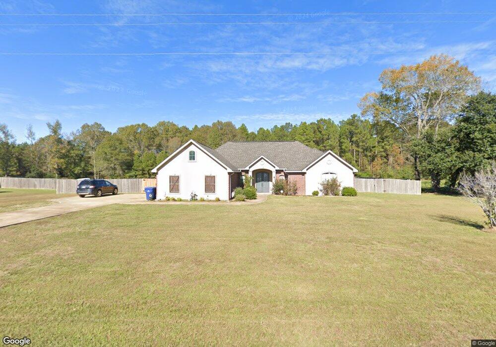
123 Eagle Point Rd Leesville, LA 71446
Estimated Value: $313,000 - $378,000
4
Beds
2
Baths
2,420
Sq Ft
$142/Sq Ft
Est. Value
About This Home
This home is located at 123 Eagle Point Rd, Leesville, LA 71446 and is currently estimated at $344,695, approximately $142 per square foot. 123 Eagle Point Rd is a home located in Vernon Parish.
Ownership History
Date
Name
Owned For
Owner Type
Purchase Details
Closed on
Feb 5, 2015
Sold by
Neal Toby Daniel and Neal Myra Sue
Bought by
Tajeddine Simohamed and Orchi Sanae
Current Estimated Value
Purchase Details
Closed on
Feb 20, 2013
Sold by
Hensley David Eugene and Hernandez Mariana Lopez
Bought by
Neal Toby Daniel and Neal Myra Sue Wilson
Home Financials for this Owner
Home Financials are based on the most recent Mortgage that was taken out on this home.
Original Mortgage
$211,399
Interest Rate
3.44%
Mortgage Type
VA
Purchase Details
Closed on
Jan 10, 2012
Sold by
Welch William Charles and Welch Glenda Kay Hollingsworth
Bought by
Hsb Properties Llc
Create a Home Valuation Report for This Property
The Home Valuation Report is an in-depth analysis detailing your home's value as well as a comparison with similar homes in the area
Purchase History
| Date | Buyer | Sale Price | Title Company |
|---|---|---|---|
| Tajeddine Simohamed | $219,000 | Permitted Title | |
| Neal Toby Daniel | $206,950 | -- | |
| Hsb Properties Llc | $20,000 | -- |
Source: Public Records
Mortgage History
| Date | Status | Borrower | Loan Amount |
|---|---|---|---|
| Previous Owner | Neal Toby Daniel | $211,399 |
Source: Public Records
Tax History
| Year | Tax Paid | Tax Assessment Tax Assessment Total Assessment is a certain percentage of the fair market value that is determined by local assessors to be the total taxable value of land and additions on the property. | Land | Improvement |
|---|---|---|---|---|
| 2025 | $3,618 | $28,030 | $2,100 | $25,930 |
| 2024 | $3,604 | $28,030 | $2,100 | $25,930 |
| 2023 | $3,367 | $28,030 | $2,100 | $25,930 |
| 2022 | $2,948 | $22,280 | $2,100 | $20,180 |
| 2021 | $3,040 | $22,280 | $2,100 | $20,180 |
| 2020 | $2,699 | $19,930 | $1,500 | $18,430 |
| 2019 | $2,733 | $19,930 | $1,500 | $18,430 |
| 2018 | $2,707 | $19,930 | $1,500 | $18,430 |
| 2017 | $2,709 | $19,930 | $1,500 | $18,430 |
| 2015 | $2,737 | $19,930 | $1,500 | $18,430 |
| 2014 | $2,471 | $18,500 | $1,500 | $17,000 |
| 2013 | $2,512 | $18,500 | $1,500 | $17,000 |
Source: Public Records
Map
Nearby Homes
- 243 Cornwell Rd
- 2721 Liliedahl Rd
- 192 Sharon Dr
- 192 Sharon Dr Unit (Rosepine)
- 8983 Main St
- 7 Woodland Pkwy
- 178
- 545 Delia Dr
- 156 Williams Way
- 559 Delia Dr
- 151 Liberty Dr
- 1778 Byron
- 245 Ambler Rd
- 0 Lake Charles Hwy Unit SWL24003728
- 0 Lake Charles Hwy Unit 48-56
- 6628 Bailey Rd
- 6616 Bailey Rd
- 7197 Evans St
- 1931 Charlotte St
- 119 Barbara Dr
- 123 Eagle Point Dr
- 121 Eagle Point Rd
- 125 Eagle Point Rd
- 125 Eagle Point Rd Unit DRIVE
- 124 Eagle Point Dr
- 122 Eagle Point Rd
- 124 Eagle Point Rd
- 126 Eagle Point Rd
- 127 Eagle Point Rd
- 120 Eagle Point Rd
- 128 Eagle Point Rd Unit Drive
- 128 Eagle Point Rd
- 129 Eagle Point Rd
- 118 Eagle Point Dr
- 130 Eagle Point Rd
- 130 Eagle Point Rd Unit ROAD
- 117 Eagle Point Rd
- 119 Eagle Point Rd
- 131 Eagle Point Rd
- 1565 Bass Rd
Your Personal Tour Guide
Ask me questions while you tour the home.