Estimated Value: $385,121 - $573,000
About This Home
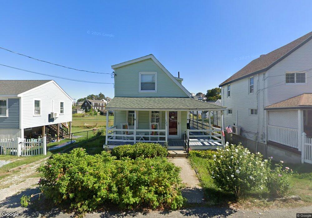
This home is located at 123 Hampton Cir, Hull, MA 02045 and is currently estimated at $471,530, approximately $526 per square foot. 123 Hampton Cir is a home located in Plymouth County with nearby schools including Lillian M. Jacobs Elementary School, Memorial Middle School, and Hull High School.
Ownership History
We collect this data history from publicly available records. To have your information removed, we recommend requesting removal directly through your county’s website.
Purchase Details
Purchase Details
Purchase Details
Purchase History
We collect this data history from publicly available records. To have your information removed, we recommend requesting removal directly through your county’s website.
| Date | Buyer | Sale Price | Title Company |
|---|---|---|---|
| -- | None Available | ||
| $208,000 | -- | ||
| $128,000 | -- |
Mortgage History
We collect this data history from publicly available records. To have your information removed, we recommend requesting removal directly through your county’s website.
| Date | Status | Borrower | Loan Amount |
|---|---|---|---|
| Previous Owner | $272,000 | ||
| Previous Owner | $50,000 |
Tax History
We collect this data history from publicly available records. To have your information removed, we recommend requesting removal directly through your county’s website.
| Year | Tax Paid | Tax Assessment Tax Assessment Total Assessment is a certain percentage of the fair market value that is determined by local assessors to be the total taxable value of land and additions on the property. | Land | Improvement |
|---|---|---|---|---|
| 2025 | $3,485 | $311,200 | $175,800 | $135,400 |
| 2024 | $3,299 | $283,200 | $170,100 | $113,100 |
| 2023 | $3,231 | $265,500 | $158,800 | $106,700 |
| 2022 | $3,117 | $248,600 | $147,400 | $101,200 |
| 2021 | $0 | $230,300 | $130,400 | $99,900 |
| 2020 | $6,757 | $227,300 | $130,400 | $96,900 |
| 2019 | $2,804 | $214,900 | $124,700 | $90,200 |
| 2018 | $2,730 | $203,400 | $124,700 | $78,700 |
| 2017 | $2,699 | $196,700 | $124,700 | $72,000 |
| 2016 | $2,652 | $196,700 | $124,700 | $72,000 |
| 2015 | $2,466 | $176,900 | $104,900 | $72,000 |
| 2014 | $2,388 | $172,200 | $104,900 | $67,300 |
Map
- 31A Merrill Rd
- 20 Hillside Rd
- 7 Bay St Unit 3
- 77 Salisbury St
- 202 N Truro St
- 00 George Washington Blvd
- 155 George Washington Blvd Unit 205
- 26 Manomet Ave
- 67 Newport Rd
- 15 Park Ave Unit 211
- 15 Park Ave Unit 107
- 15 Park Ave Unit 307
- 30 Rockland Cir
- 84 Newport Rd
- 107 Newport Rd
- 10 Berkley Rd Unit A
- 22 Wyola Rd
- 23 Wyola Rd
- 121 Nantasket Ave Unit 805
- 120 Nantasket Ave Unit 204
- 119 Hampton Cir
- 18 Marginal Rd
- 16 Marginal Rd
- 14 Marginal Rd
- 121 Hampton Cir
- 120 Hampton Cir
- 112 Hampton Cir
- 122 Hampton Cir
- 12 Marginal Rd
- 17 Lincoln Ave
- 15 Marginal Rd
- 17 Marginal Rd
- 125 Hampton Cir
- 110 Hampton Cir
- 12 Old Colony Rd
- 15 Lincoln Ave
- 10 Old Colony Rd
- 10 Old Colony Rd
- 10 Marginal Rd
- 109 Hampton Cir
Ask me questions while you tour the home.