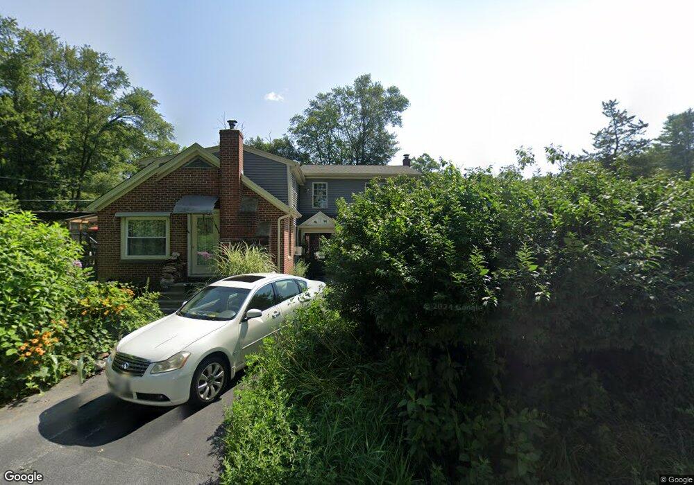
123 Johnson Rd Foster, RI 02825
Estimated Value: $386,000 - $720,000
3
Beds
2
Baths
2,753
Sq Ft
$193/Sq Ft
Est. Value
About This Home
This home is located at 123 Johnson Rd, Foster, RI 02825 and is currently estimated at $530,676, approximately $192 per square foot. 123 Johnson Rd is a home located in Providence County with nearby schools including Capt. Isaac Paine El. School, Ponaganset Middle School, and Ponaganset High School.
Ownership History
Date
Name
Owned For
Owner Type
Purchase Details
Closed on
Dec 12, 2018
Sold by
Moffat Keith D and Melucci Denise
Bought by
Melucci Denise
Current Estimated Value
Home Financials for this Owner
Home Financials are based on the most recent Mortgage that was taken out on this home.
Original Mortgage
$393,000
Outstanding Balance
$342,139
Interest Rate
4.8%
Mortgage Type
New Conventional
Estimated Equity
$188,537
Purchase Details
Closed on
Dec 17, 1999
Sold by
Giorgi Americo Est
Bought by
Moffat Keith D
Create a Home Valuation Report for This Property
The Home Valuation Report is an in-depth analysis detailing your home's value as well as a comparison with similar homes in the area
Home Values in the Area
Average Home Value in this Area
Purchase History
| Date | Buyer | Sale Price | Title Company |
|---|---|---|---|
| Melucci Denise | -- | -- | |
| Moffat Keith D | $95,000 | -- |
Source: Public Records
Mortgage History
| Date | Status | Borrower | Loan Amount |
|---|---|---|---|
| Open | Melucci Denise | $393,000 | |
| Previous Owner | Moffat Keith D | $215,000 | |
| Previous Owner | Moffat Keith D | $52,800 | |
| Previous Owner | Moffat Keith D | $194,000 |
Source: Public Records
Tax History
| Year | Tax Paid | Tax Assessment Tax Assessment Total Assessment is a certain percentage of the fair market value that is determined by local assessors to be the total taxable value of land and additions on the property. | Land | Improvement |
|---|---|---|---|---|
| 2025 | $10,388 | $482,700 | $127,900 | $354,800 |
| 2024 | $10,055 | $482,700 | $127,900 | $354,800 |
| 2023 | $8,372 | $369,300 | $98,600 | $270,700 |
| 2022 | $8,110 | $369,300 | $98,600 | $270,700 |
| 2021 | $7,881 | $369,300 | $98,600 | $270,700 |
| 2020 | $7,403 | $311,200 | $85,800 | $225,400 |
| 2018 | $7,108 | $311,200 | $85,800 | $225,400 |
| 2017 | $7,684 | $330,500 | $85,800 | $244,700 |
| 2015 | $7,079 | $330,500 | $85,800 | $244,700 |
| 2014 | $6,958 | $330,400 | $85,800 | $244,600 |
Source: Public Records
Map
Nearby Homes
- 61 Howard Hill Rd
- 55 Howard Hill Rd
- 188 Danielson Pike
- 18 King Rd
- 120 Danielson Pike
- 32 Wright Rd
- 91 Danielson Pike
- 0 Central Pike
- 29 Mount Hygeia Rd
- 1567 Plainfield Pike
- 13 Shippee Schoolhouse Rd
- 172 Bailey Hill Rd
- 980 Plainfield Pike
- 1150 Plainfield Pike
- 41 Margaret Henry Rd
- 0 E Killingly Rd Unit 1406613
- 119 E Killingly Rd
- 23 Bailey Hill Village
- 26 Danielson Pike
- 395 Bailey Hill Rd
- 122 Johnson Rd
- 103A S Killingly Rd
- 103A S Killingly Rd
- 124A Johnson Rd
- 124 Johnson Rd
- 100 S Killingly Rd
- 103 S Killingly Rd
- 104 S Killingly Rd
- 0 0killingly Rd Pole 7 S Unit EC30214261
- 106 S Killingly Rd
- 105A S Killingly Rd
- 99 S Killingly Rd
- 0 S Killingly Rd Unit 1406613
- 0 S Killingly Rd Unit 312963
- 0 S Killingly Rd Unit 306429
- 0 S Killingly Rd Unit 306446
- 0 S Killingly Rd Unit 556698
- 0 S Killingly Rd Unit 13581
- 0 S Killingly Rd Unit 17270
- 0 S Killingly Rd Unit 558110
Your Personal Tour Guide
Ask me questions while you tour the home.