
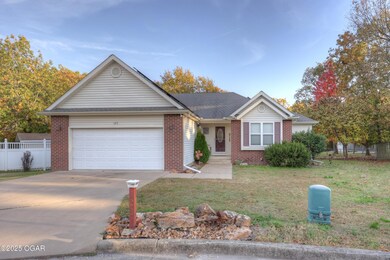


123 Randolph Dr Carl Junction, MO 64834
Estimated payment $1,527/month
Highlights
- Deck
- Main Floor Primary Bedroom
- Porch
- Carl Junction Primary School (2-3) Rated A-
- Separate Outdoor Workshop
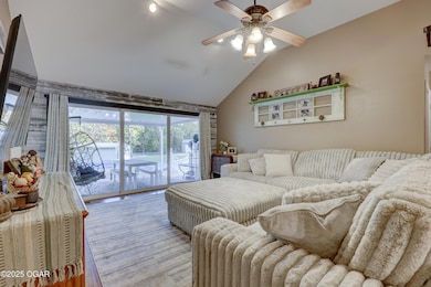
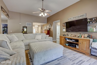
- Living Room
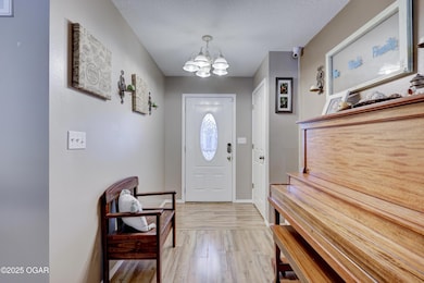
About This Home
Welcome home to this incredible 3-bedroom, 2-bathroom gem nestled at the end of a quiet cul-de-sac in a fantastic Carl Junction neighborhood. Offering 1,700 sq. ft. of comfortable living space, this property delivers on privacy, fun, and functionality. Situated on an expansive almost 3/4 acre lot, this home truly has it all. Enjoy the privacy of your backyard on your expansive deck around the above ground pool. The backyard is fully fenced and has a huge 25x50 insulated metal shop! An additional storage shed provides plenty of room for tools and equipment. Don't forget about the Storm shelter and the solar panels for utility savings! Don't miss out on the Carl Junction gem!
Listing Agent
The Lehman Home Brandon Lehman
KELLER WILLIAMS REALTY ELEVATE License #2013025634 Listed on: 11/06/2025

Home Details
Home Type
- Single Family
Year Built
- Built in 2004
Parking
- 2 Car Garage
Home Design
- Brick Exterior Construction
- Block Foundation
- Wood Frame Construction
- Composition Roof
- Vinyl Siding
- Vinyl Construction Material
Interior Spaces
- 1,701 Sq Ft Home
- Living Room
- Utility Room
Kitchen
- Stove
- Microwave
- Dishwasher
Flooring
- Carpet
- Vinyl
Bedrooms and Bathrooms
- 3 Bedrooms
- Primary Bedroom on Main
- 2 Full Bathrooms
Outdoor Features
- Deck
- Separate Outdoor Workshop
- Shed
- Porch
Schools
- Carl Junction Elementary School
Additional Features
- Chain Link Fence
- Central Heating and Cooling System
Map
Home Values in the Area
Average Home Value in this Area
Tax History
| Year | Tax Paid | Tax Assessment Tax Assessment Total Assessment is a certain percentage of the fair market value that is determined by local assessors to be the total taxable value of land and additions on the property. | Land | Improvement |
|---|---|---|---|---|
| 2025 | $1,300 | $25,790 | $1,640 | $24,150 |
| 2024 | $1,308 | $22,210 | $1,640 | $20,570 |
| 2023 | $1,308 | $22,210 | $1,640 | $20,570 |
| 2022 | $1,431 | $24,240 | $1,640 | $22,600 |
| 2021 | $1,228 | $24,240 | $1,640 | $22,600 |
| 2020 | $1,145 | $22,220 | $1,640 | $20,580 |
| 2019 | $1,087 | $22,220 | $1,640 | $20,580 |
| 2018 | $1,088 | $22,290 | $0 | $0 |
| 2017 | $1,091 | $22,290 | $0 | $0 |
| 2016 | $1,105 | $22,790 | $0 | $0 |
| 2015 | -- | $22,790 | $0 | $0 |
| 2014 | -- | $22,790 | $0 | $0 |
Property History
| Date | Event | Price | List to Sale | Price per Sq Ft |
|---|---|---|---|---|
| 12/05/2025 12/05/25 | Pending | -- | -- | -- |
| 11/26/2025 11/26/25 | Price Changed | $269,900 | -3.6% | $159 / Sq Ft |
| 11/06/2025 11/06/25 | For Sale | $279,900 | -- | $165 / Sq Ft |
Purchase History
| Date | Type | Sale Price | Title Company |
|---|---|---|---|
| Warranty Deed | -- | None Available |
Mortgage History
| Date | Status | Loan Amount | Loan Type |
|---|---|---|---|
| Open | $139,795 | New Conventional |
Source: Ozark Gateway Association of REALTORS®
MLS Number: 256186
APN: 16-2.0-10-40-002-011.002
Disclaimer: Certain information contained herein is derived from information provided by parties other than Homes.com. All information provided is deemed reliable, but is not guaranteed to be accurate and should be independently verified.
![]() IDX information is provided exclusively for personal, non-commercial use, and may not be used for any purpose other than to identify prospective properties consumers may be interested in purchasing. Information is deemed reliable but not guaranteed.
IDX information is provided exclusively for personal, non-commercial use, and may not be used for any purpose other than to identify prospective properties consumers may be interested in purchasing. Information is deemed reliable but not guaranteed.
- 117 Rocky Ln
- 116 Rocky Ln
- 25122 Gum Rd
- 7570 Quince Ln
- 133 Red Oak Dr
- 121 Forest Dr
- 401 Dogwood Trails Loop
- 512 Dogwood Trails Loop
- 6548 Mo-171
- 506 Lone Elm Dr
- 5981 Pearl St
- 2626 Joplin St
- XXX Lone Elm
- Lot 1B Hwy 171 & Fir Rd
- Lot 1A Hwy 171 & Fir Rd
- Lot 1 Hwy 171 & Fir Rd
- Xxx Wall St
- 235 Timber Ln
- LOT 4C Hwy 171 & Fir Rd Unit 4C
- 304 Belgian Blue Blvd