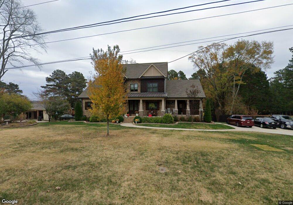
123 Robin Rd Madison, AL 35758
Estimated Value: $550,000 - $671,000
Studio
1
Bath
2,345
Sq Ft
$257/Sq Ft
Est. Value
About This Home
This home is located at 123 Robin Rd, Madison, AL 35758 and is currently estimated at $603,132, approximately $257 per square foot. 123 Robin Rd is a home with nearby schools including Rainbow Elementary School, Discovery Middle School, and Bob Jones High School.
Ownership History
Date
Name
Owned For
Owner Type
Purchase Details
Closed on
Sep 14, 2018
Sold by
Richard Brande M
Bought by
Richard Jeremy Dewayne and Richard Brande M
Current Estimated Value
Home Financials for this Owner
Home Financials are based on the most recent Mortgage that was taken out on this home.
Original Mortgage
$395,000
Outstanding Balance
$342,326
Interest Rate
4.5%
Mortgage Type
New Conventional
Estimated Equity
$260,806
Purchase Details
Closed on
May 25, 2017
Sold by
Harris Shirley V
Bought by
Richard Brande M
Create a Home Valuation Report for This Property
The Home Valuation Report is an in-depth analysis detailing your home's value as well as a comparison with similar homes in the area
Home Values in the Area
Average Home Value in this Area
Purchase History
| Date | Buyer | Sale Price | Title Company |
|---|---|---|---|
| Richard Jeremy Dewayne | -- | None Available | |
| Richard Brande M | $24,000 | None Available |
Source: Public Records
Mortgage History
| Date | Status | Borrower | Loan Amount |
|---|---|---|---|
| Open | Richard Jeremy Dewayne | $395,000 |
Source: Public Records
Tax History
| Year | Tax Paid | Tax Assessment Tax Assessment Total Assessment is a certain percentage of the fair market value that is determined by local assessors to be the total taxable value of land and additions on the property. | Land | Improvement |
|---|---|---|---|---|
| 2025 | $4,146 | $60,200 | $2,720 | $57,480 |
| 2024 | $4,146 | $56,280 | $2,720 | $53,560 |
| 2023 | $3,873 | $56,280 | $2,720 | $53,560 |
| 2022 | $3,444 | $50,100 | $2,720 | $47,380 |
| 2021 | $3,201 | $46,600 | $2,720 | $43,880 |
| 2020 | $3,176 | $46,240 | $2,360 | $43,880 |
| 2019 | $2,621 | $46,240 | $2,360 | $43,880 |
| 2018 | $271 | $4,720 | $0 | $0 |
| 2017 | $130 | $2,360 | $0 | $0 |
| 2016 | $130 | $2,360 | $0 | $0 |
| 2015 | $130 | $2,360 | $0 | $0 |
| 2014 | $120 | $2,360 | $0 | $0 |
Source: Public Records
Map
Nearby Homes
- 118 Claypool Dr
- 114 Claypool Dr
- 124 Imogene Way
- 102 Forest Pointe Dr
- 289 Yancy Rd
- 161 Stoneway Trail
- 127 Intracoastal Dr
- 139 Stoneway Trail
- 1311 Towne Creek Place NW
- 1309 Towne Creek Place NW
- 212 Harborview Dr
- 243 Postwood Ct
- 6432 Lenox Hill Way NW
- 105 Tidewater Dr
- 6426 Lenox Hill Way
- 1257 Slaughter Rd
- 6425 Lenox Hill Way
- 6423 Lenox Hill Way
- 162 Southwood Dr
- 219 Iron Wood Ct
- 105 Robin Rd
- 133 Robin Rd
- 153 Robin Rd
- 1618 Slaughter Rd Unit D
- 1618 Slaughter Rd Unit B
- 1618 Slaughter Rd Unit D & E
- 1618 Slaughter Rd Unit C
- 1618 Slaughter Rd Unit F
- 1618 Slaughter Rd Unit E
- 1618 Slaughter Rd Unit B&C
- 1618 Slaughter Rd
- 1618 Slaughter Rd Unit D
- 104 Robin Rd
- 1634 Slaughter Rd Unit A&B
- 1634 Slaughter Rd Unit A
- 1634 Slaughter Rd Unit B
- 173 Robin Rd
- 1578 Slaughter Rd
- 1595 Slaughter Rd Unit A
- 1595 Slaughter Rd
Your Personal Tour Guide
Ask me questions while you tour the home.