Estimated Value: $65,000 - $109,000
2
Beds
1
Bath
660
Sq Ft
$122/Sq Ft
Est. Value
About This Home
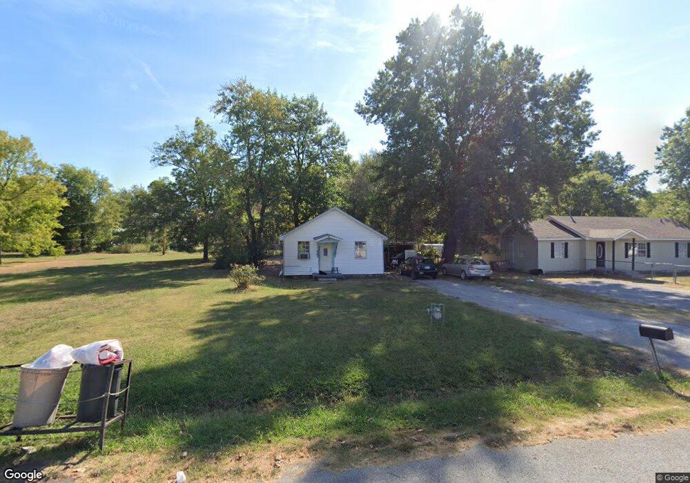
This home is located at 123 S Mayes St, Pryor, OK 74361 and is currently estimated at $80,599, approximately $122 per square foot. 123 S Mayes St is a home located in Mayes County with nearby schools including Pryor Middle School, Pryor High School, and William Bradford Christian School.
Ownership History
Date
Name
Owned For
Owner Type
Purchase Details
Closed on
Sep 26, 2012
Sold by
Yoder Nrice
Bought by
Yoder Bruce K
Current Estimated Value
Purchase Details
Closed on
Mar 20, 2008
Sold by
Us Bank National Assn
Bought by
Larremore Ii Clay R and Larremore Micki
Purchase Details
Closed on
Apr 17, 2006
Sold by
Keely Lawrence C and Kelly Mary
Bought by
Sowres Bobby G
Home Financials for this Owner
Home Financials are based on the most recent Mortgage that was taken out on this home.
Original Mortgage
$52,000
Interest Rate
9.77%
Mortgage Type
Adjustable Rate Mortgage/ARM
Purchase Details
Closed on
Nov 25, 1996
Sold by
Blockcolski Doris J
Bought by
Kelley Lawrence C
Create a Home Valuation Report for This Property
The Home Valuation Report is an in-depth analysis detailing your home's value as well as a comparison with similar homes in the area
Purchase History
| Date | Buyer | Sale Price | Title Company |
|---|---|---|---|
| Yoder Bruce K | -- | None Available | |
| Larremore Ii Clay R | $22,500 | Oklahoma Reo Closing & Title | |
| Sowres Bobby G | $65,000 | None Available | |
| Kelley Lawrence C | $5,000 | -- |
Source: Public Records
Mortgage History
| Date | Status | Borrower | Loan Amount |
|---|---|---|---|
| Previous Owner | Sowres Bobby G | $52,000 |
Source: Public Records
Tax History
| Year | Tax Paid | Tax Assessment Tax Assessment Total Assessment is a certain percentage of the fair market value that is determined by local assessors to be the total taxable value of land and additions on the property. | Land | Improvement |
|---|---|---|---|---|
| 2025 | $508 | $6,019 | $2,548 | $3,471 |
| 2023 | $484 | $5,460 | $2,388 | $3,072 |
| 2022 | $435 | $5,200 | $2,376 | $2,824 |
| 2021 | $418 | $4,952 | $2,357 | $2,595 |
| 2020 | $390 | $4,716 | $2,318 | $2,398 |
| 2019 | $384 | $4,492 | $2,156 | $2,336 |
| 2018 | $363 | $4,278 | $1,980 | $2,298 |
| 2017 | $347 | $4,394 | $1,980 | $2,414 |
| 2016 | $349 | $4,377 | $1,356 | $3,021 |
| 2015 | $355 | $4,377 | $1,356 | $3,021 |
| 2014 | $355 | $4,377 | $1,356 | $3,021 |
Source: Public Records
Map
Nearby Homes
- 122 S Whitaker St
- 120 S Whitaker St
- 15 S Mayes St
- 0 W Graham St Unit 2605787
- 811 S Adair St
- 114 N Whitaker St
- 215 W 481 Rd
- 245 W 481 Rd
- 4748 N 4318 Rd
- 187 W 481 Rd
- 157 W 481 Rd
- 204 S Rowe St
- 404 N Maple St
- 107 S Coo Y Yah St Unit B
- 420 NW 5th St
- 0 W Highway 20
- 2 NW 5th St
- 514 S Vann St
- 335 N Taylor St
- 218 N Vann St
- 125 S Mayes St
- 121 S Mayes St
- 209 SW 2nd St
- 209 SW 2nd St
- 115 S Mayes St
- 0 S Mayes St
- 126 S Whitaker St
- 264 SW 2nd St
- 116 S Whitaker St
- 210 SW 2nd St
- 113 S Mayes St
- 200 S Whitaker St
- 112 S Whitaker St
- 310 SW 2nd St
- 108 S Mayes St
- 202 S Whitaker St
- 109 S Mayes St
- 202 S Mayes St
- 108 S Whitaker St
- 204 S Whitaker St
Your Personal Tour Guide
Ask me questions while you tour the home.