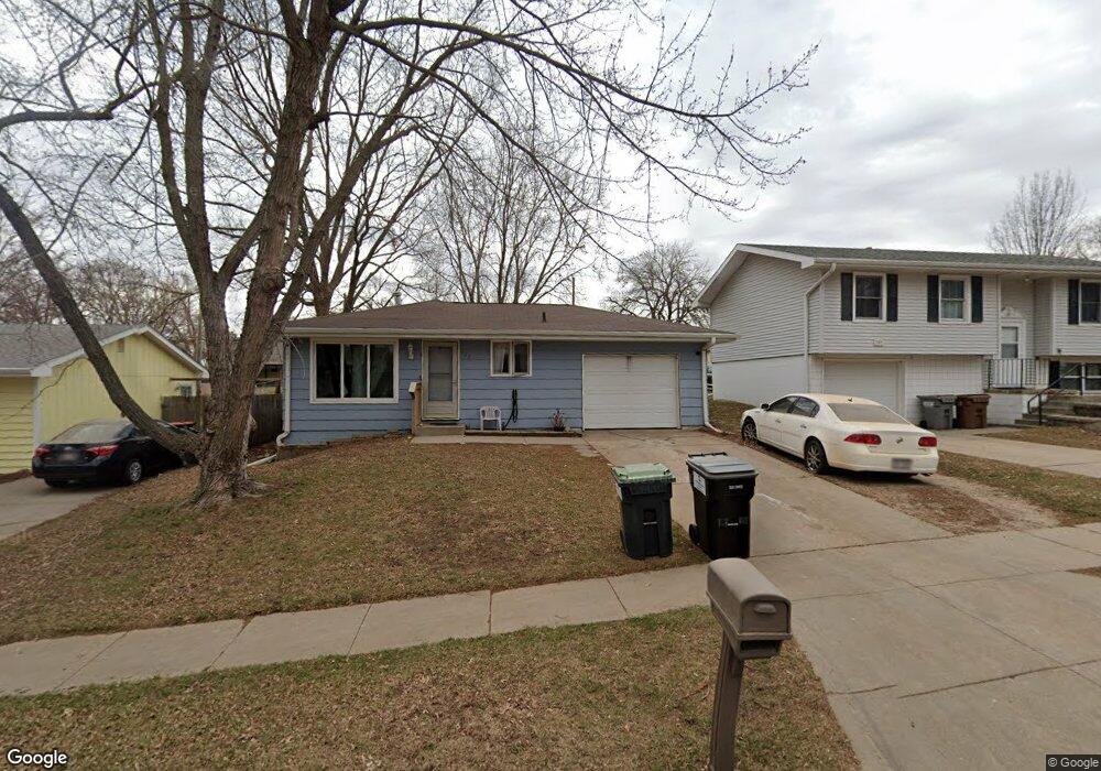
123 W Dawes Ave Lincoln, NE 68521
Northwest Lincoln NeighborhoodEstimated Value: $191,000 - $213,452
2
Beds
1
Bath
943
Sq Ft
$212/Sq Ft
Est. Value
About This Home
This home is located at 123 W Dawes Ave, Lincoln, NE 68521 and is currently estimated at $199,863, approximately $211 per square foot. 123 W Dawes Ave is a home located in Lancaster County with nearby schools including West Lincoln Elementary School, Goodrich Middle School, and North Star High School.
Ownership History
Date
Name
Owned For
Owner Type
Purchase Details
Closed on
Dec 21, 2006
Sold by
Federal National Mortgage Association
Bought by
Holman Kari J
Current Estimated Value
Home Financials for this Owner
Home Financials are based on the most recent Mortgage that was taken out on this home.
Original Mortgage
$61,600
Outstanding Balance
$37,799
Interest Rate
6.79%
Mortgage Type
Unknown
Estimated Equity
$162,064
Purchase Details
Closed on
Aug 21, 2006
Sold by
Howell Danny L and Howell Cathy A
Bought by
Federal National Mortgage Association
Create a Home Valuation Report for This Property
The Home Valuation Report is an in-depth analysis detailing your home's value as well as a comparison with similar homes in the area
Home Values in the Area
Average Home Value in this Area
Purchase History
| Date | Buyer | Sale Price | Title Company |
|---|---|---|---|
| Holman Kari J | -- | Ct | |
| Federal National Mortgage Association | $81,600 | None Available |
Source: Public Records
Mortgage History
| Date | Status | Borrower | Loan Amount |
|---|---|---|---|
| Open | Holman Kari J | $61,600 |
Source: Public Records
Tax History Compared to Growth
Tax History
| Year | Tax Paid | Tax Assessment Tax Assessment Total Assessment is a certain percentage of the fair market value that is determined by local assessors to be the total taxable value of land and additions on the property. | Land | Improvement |
|---|---|---|---|---|
| 2025 | $2,170 | $194,800 | $45,000 | $149,800 |
| 2024 | $2,170 | $157,000 | $35,000 | $122,000 |
| 2023 | $2,631 | $157,000 | $35,000 | $122,000 |
| 2022 | $2,683 | $134,600 | $25,000 | $109,600 |
| 2021 | $2,538 | $134,600 | $25,000 | $109,600 |
| 2020 | $2,102 | $110,000 | $25,000 | $85,000 |
| 2019 | $2,102 | $110,000 | $25,000 | $85,000 |
| 2018 | $1,885 | $98,200 | $25,000 | $73,200 |
| 2017 | $1,902 | $98,200 | $25,000 | $73,200 |
| 2016 | $1,682 | $86,400 | $25,000 | $61,400 |
| 2015 | $1,671 | $86,400 | $25,000 | $61,400 |
| 2014 | $1,517 | $78,000 | $25,000 | $53,000 |
| 2013 | -- | $78,000 | $25,000 | $53,000 |
Source: Public Records
Map
Nearby Homes
- 122 W Saunders Ave
- 431 W Belmont Ave
- 2503 NW 6th St
- 2808 NW 7th St
- 455 Laramie Trail
- 730 W Dawes Ave
- 2500 NW 8th St
- 3100 NW 7th St
- 406 Knox St
- 205 W Treehaven Dr
- 405 Judson St
- 911 Adams St
- 3241 Mickaela Ln
- 1020 Furnas Ave
- 1715 W Trout Dr
- 635 W Fairfield St
- 1330 Pelican Bay Place
- 820 Groveland St
- 1219 Garber Ave
- 239 W Irving St Unit Portfolio
- 127 W Dawes Ave
- 119 W Dawes Ave
- 129 W Dawes Ave
- 115 W Dawes Ave
- 116 W Saunders Ave
- 135 W Dawes Ave
- 111 W Dawes Ave
- 118 W Saunders Ave
- 114 W Saunders Ave
- 120 W Dawes Ave
- 112 W Saunders Ave
- 124 W Dawes Ave
- 116 W Dawes Ave
- 130 W Dawes Ave
- 137 W Dawes Ave
- 107 W Dawes Ave
- 126 W Saunders Ave
- 108 W Saunders Ave
- 132 W Dawes Ave
- 112 W Dawes Ave