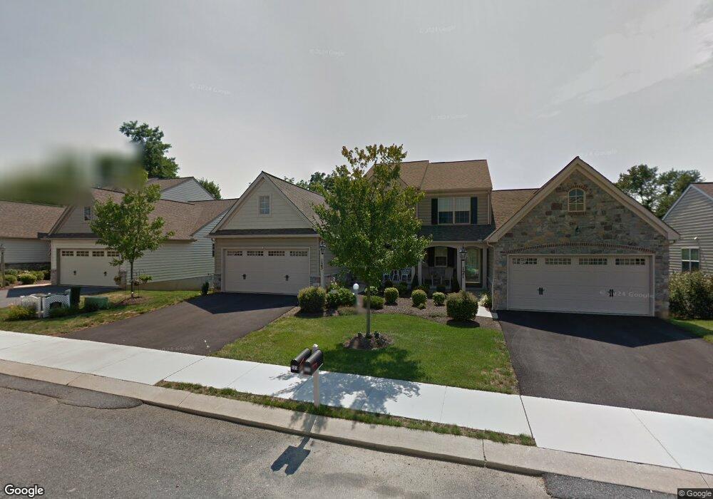
123 Waypoint Dr Lancaster, PA 17603
Meadia Heights NeighborhoodEstimated Value: $358,000 - $395,753
3
Beds
3
Baths
1,620
Sq Ft
$234/Sq Ft
Est. Value
About This Home
This home is located at 123 Waypoint Dr, Lancaster, PA 17603 and is currently estimated at $378,438, approximately $233 per square foot. 123 Waypoint Dr is a home located in Lancaster County with nearby schools including Elizabeth R Martin Elementary School, Wheatland Middle School, and McCaskey High School.
Ownership History
Date
Name
Owned For
Owner Type
Purchase Details
Closed on
Apr 18, 2024
Sold by
Eves Barry and Eves Sandra L
Bought by
Eves Barry N and Eves Sandra L
Current Estimated Value
Purchase Details
Closed on
Jan 18, 2007
Sold by
Hogan Herr Wolf
Bought by
Eves Barry and Eves Sandra L
Home Financials for this Owner
Home Financials are based on the most recent Mortgage that was taken out on this home.
Original Mortgage
$168,000
Interest Rate
6.14%
Mortgage Type
Purchase Money Mortgage
Create a Home Valuation Report for This Property
The Home Valuation Report is an in-depth analysis detailing your home's value as well as a comparison with similar homes in the area
Home Values in the Area
Average Home Value in this Area
Purchase History
| Date | Buyer | Sale Price | Title Company |
|---|---|---|---|
| Eves Barry N | -- | None Listed On Document | |
| Eves Barry | $245,865 | None Available |
Source: Public Records
Mortgage History
| Date | Status | Borrower | Loan Amount |
|---|---|---|---|
| Previous Owner | Eves Barry | $168,000 |
Source: Public Records
Tax History Compared to Growth
Tax History
| Year | Tax Paid | Tax Assessment Tax Assessment Total Assessment is a certain percentage of the fair market value that is determined by local assessors to be the total taxable value of land and additions on the property. | Land | Improvement |
|---|---|---|---|---|
| 2025 | $6,489 | $225,000 | $32,300 | $192,700 |
| 2024 | $6,489 | $225,000 | $32,300 | $192,700 |
| 2023 | $6,339 | $225,000 | $32,300 | $192,700 |
| 2022 | $5,961 | $225,000 | $32,300 | $192,700 |
| 2021 | $5,781 | $225,000 | $32,300 | $192,700 |
| 2020 | $5,781 | $225,000 | $32,300 | $192,700 |
| 2019 | $5,658 | $225,000 | $32,300 | $192,700 |
| 2018 | $4,362 | $225,000 | $32,300 | $192,700 |
| 2017 | $6,012 | $183,900 | $20,100 | $163,800 |
| 2016 | $5,902 | $183,900 | $20,100 | $163,800 |
| 2015 | $797 | $183,900 | $20,100 | $163,800 |
| 2014 | $4,479 | $183,900 | $20,100 | $163,800 |
Source: Public Records
Map
Nearby Homes
- 113 Hillard Field
- 112 Hillard Field
- 111 Hillard Field
- 115 Hillard
- 120 Hillard Field
- 137 Goldenfield Dr
- 109 Hillard
- 43 Farm Ln
- 116 Hillard Field
- 123 Hillard Field
- 114 Hillard Field
- 103 Gentlemens Way
- 63 Quaker Hills Rd
- 2435 Honeysuckle Ln
- 1922 Edington Place
- 2460 Honeysuckle Ln
- 2440 Water Valley Rd
- 1763 Betz Farm Dr
- 65 Mill Pond Dr
- 34 Deep Hollow Ln
- 121 Waypoint Dr
- 125 Waypoint Dr
- 119 Waypoint Dr
- 127 Waypoint Dr
- 117 Waypoint Dr
- 0 Waypoint Dr Unit 241 1003831917
- 0 Waypoint Dr Unit 220 1003498839
- 0 Waypoint Dr Unit 241 1002848581
- 0 Waypoint Dr Unit 219 1003809927
- 0 Waypoint Dr Unit 194842
- 0 Waypoint Dr Unit 200193
- 0 Waypoint Dr Unit 200228
- 0 Waypoint Dr Unit 218435
- 0 Waypoint Dr Unit 218446
- 0 Waypoint Dr Unit 224917
- 0 Waypoint Dr Unit 242510
- 0 Waypoint Dr Unit 239 PALA152056
- 2 Southbrook Dr Unit 94
- 2 Southbrook Dr
- 1 Water Leaf Rd