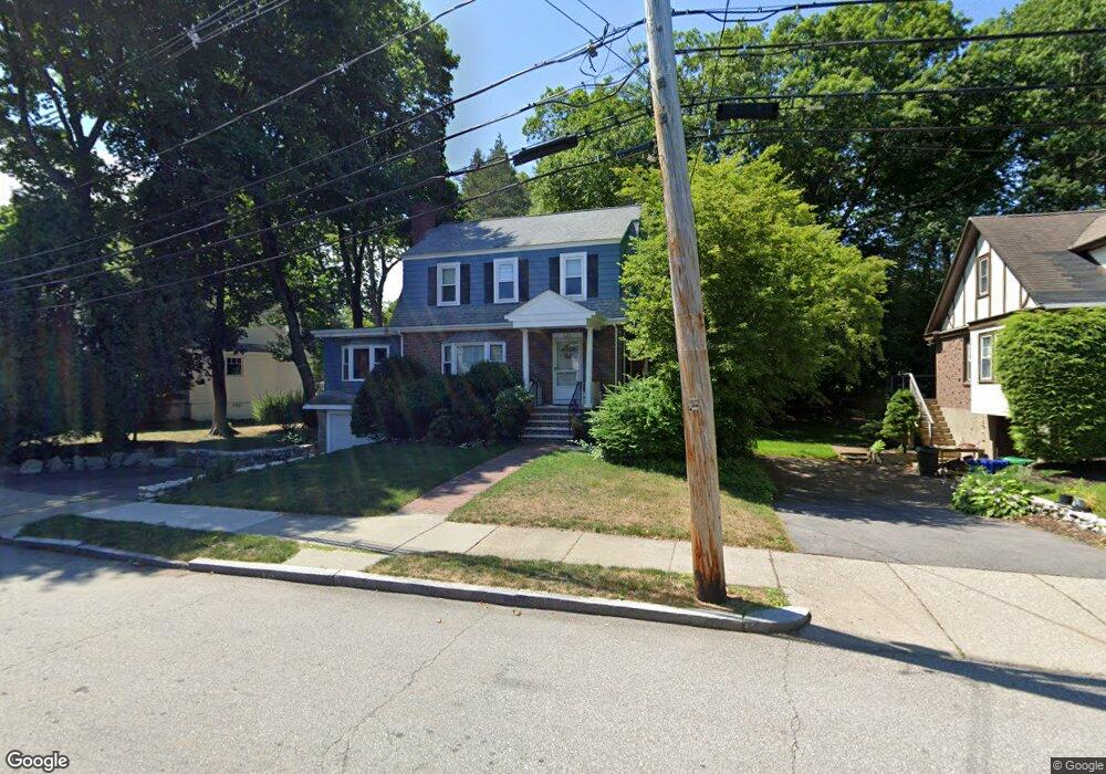
123 Woodcliff Rd Newton Highlands, MA 02461
Newton Highlands NeighborhoodEstimated Value: $1,221,000 - $1,653,000
3
Beds
2
Baths
1,809
Sq Ft
$772/Sq Ft
Est. Value
About This Home
This home is located at 123 Woodcliff Rd, Newton Highlands, MA 02461 and is currently estimated at $1,396,245, approximately $771 per square foot. 123 Woodcliff Rd is a home located in Middlesex County with nearby schools including Countryside Elementary School, Charles E Brown Middle School, and Newton South High School.
Ownership History
Date
Name
Owned For
Owner Type
Purchase Details
Closed on
May 22, 2009
Sold by
Morrison Thomas E and Morrison Margaret A
Bought by
Margaret A Morrison T and Morrison Thomas E
Current Estimated Value
Create a Home Valuation Report for This Property
The Home Valuation Report is an in-depth analysis detailing your home's value as well as a comparison with similar homes in the area
Home Values in the Area
Average Home Value in this Area
Purchase History
| Date | Buyer | Sale Price | Title Company |
|---|---|---|---|
| Margaret A Morrison T | -- | -- |
Source: Public Records
Tax History Compared to Growth
Tax History
| Year | Tax Paid | Tax Assessment Tax Assessment Total Assessment is a certain percentage of the fair market value that is determined by local assessors to be the total taxable value of land and additions on the property. | Land | Improvement |
|---|---|---|---|---|
| 2025 | $10,498 | $1,071,200 | $869,900 | $201,300 |
| 2024 | $10,150 | $1,040,000 | $844,600 | $195,400 |
| 2023 | $9,536 | $936,700 | $640,400 | $296,300 |
| 2022 | $9,124 | $867,300 | $593,000 | $274,300 |
| 2021 | $8,804 | $818,200 | $559,400 | $258,800 |
| 2020 | $8,542 | $818,200 | $559,400 | $258,800 |
| 2019 | $8,301 | $794,400 | $543,100 | $251,300 |
| 2018 | $7,958 | $735,500 | $493,000 | $242,500 |
| 2017 | $7,716 | $693,900 | $465,100 | $228,800 |
| 2016 | $7,380 | $648,500 | $434,700 | $213,800 |
| 2015 | $7,037 | $606,100 | $406,300 | $199,800 |
Source: Public Records
Map
Nearby Homes
- 125 Oakdale Rd
- 1308 Walnut St
- 1292 Walnut St
- 671 Boylston St
- 19 Selwyn Rd
- 628 Boylston St
- 625 Boylston St
- 42 Sunhill Ln
- 250 Woodcliff Rd
- 1597 Centre St Unit 1597
- 1597 Centre St
- 1623-1625 Centre St
- 1629 Centre St
- 21 Philbrick Rd
- 36 Cannon St
- 116 Upland Ave
- 5 Halcyon Rd
- 1151 Walnut St Unit 205
- 1151 Walnut St Unit 405
- 1151 Walnut St Unit 207
- 119 Woodcliff Rd
- 133 Woodcliff Rd
- 24 Solon St
- 120 Woodcliff Rd
- 143 Woodcliff Rd
- 113 Woodcliff Rd
- 20 Solon St
- 130 Woodcliff Rd
- 117 Parker Ave
- 134 Woodcliff Rd
- 134 Woodcliff Rd Unit 2
- 114 Parker Ave
- 147 Woodcliff Rd
- 130 Oakdale Rd
- 30 Solon St
- 109 Woodcliff Rd
- 121 Parker Ave
- 18 Solon St
- 126 Oakdale Rd
- 139 Oakdale Rd