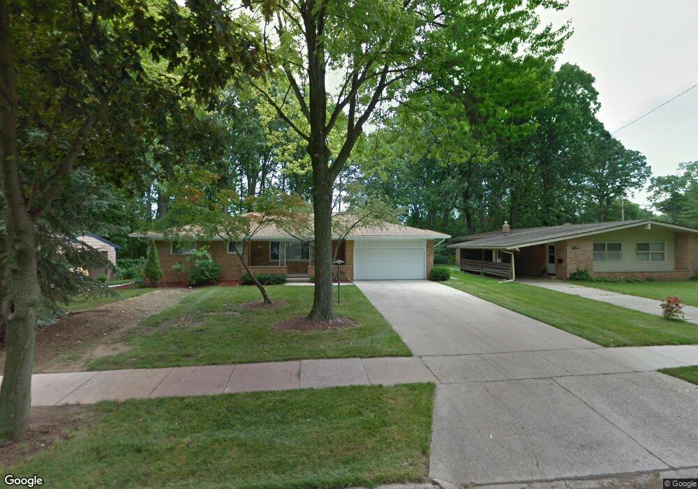
1230 Blake Ave Lansing, MI 48912
Groesbeck NeighborhoodEstimated Value: $244,000 - $275,000
3
Beds
2
Baths
1,468
Sq Ft
$179/Sq Ft
Est. Value
About This Home
This home is located at 1230 Blake Ave, Lansing, MI 48912 and is currently estimated at $262,465, approximately $178 per square foot. 1230 Blake Ave is a home located in Ingham County with nearby schools including Pattengill Academy, Willow School, and Eastern High School.
Ownership History
Date
Name
Owned For
Owner Type
Purchase Details
Closed on
Nov 21, 2008
Sold by
Mckenzie Marilyn R and Mckenzie B J
Bought by
Mckenzie Marilyn R and Marilyn R Mckenzie Trust
Current Estimated Value
Purchase Details
Closed on
Mar 20, 1998
Sold by
Saboury Sae'D Sam and Saboury Mina
Bought by
Mckenzie Jb and Mckenzie Marilyn R
Purchase Details
Closed on
Jul 1, 1994
Sold by
Saboury Sam and Saboury Mina
Bought by
Swindell Eric K and Swindell Wendy J
Create a Home Valuation Report for This Property
The Home Valuation Report is an in-depth analysis detailing your home's value as well as a comparison with similar homes in the area
Home Values in the Area
Average Home Value in this Area
Purchase History
| Date | Buyer | Sale Price | Title Company |
|---|---|---|---|
| Mckenzie Marilyn R | -- | None Available | |
| Mckenzie Jb | $122,000 | -- | |
| Swindell Eric K | -- | -- |
Source: Public Records
Tax History
| Year | Tax Paid | Tax Assessment Tax Assessment Total Assessment is a certain percentage of the fair market value that is determined by local assessors to be the total taxable value of land and additions on the property. | Land | Improvement |
|---|---|---|---|---|
| 2025 | $4,736 | $142,400 | $31,800 | $110,600 |
| 2024 | $22 | $131,200 | $24,800 | $106,400 |
| 2023 | $4,544 | $117,000 | $26,900 | $90,100 |
| 2022 | $4,345 | $103,900 | $27,300 | $76,600 |
| 2021 | $4,370 | $100,800 | $22,400 | $78,400 |
| 2020 | $1,926 | $95,700 | $22,400 | $73,300 |
| 2019 | $3,834 | $91,800 | $16,800 | $75,000 |
| 2018 | $3,538 | $74,600 | $13,500 | $61,100 |
| 2017 | $3,367 | $74,600 | $13,500 | $61,100 |
| 2016 | -- | $74,400 | $12,900 | $61,500 |
| 2015 | -- | $74,500 | $25,724 | $48,776 |
| 2014 | -- | $69,000 | $24,867 | $44,133 |
Source: Public Records
Map
Nearby Homes
- 1320 N Foster Ave
- 1706 Autumn Ln
- 2718 E Grand River Ave
- 2711 Heights Ave
- 601 N Francis Ave
- 427 Lasalle Blvd
- 1283 Chartwell Carriage Way N
- 605 N Fairview Ave
- 1304 Wolf Ct
- 605 N Clemens Ave
- 1227 Chartwell Carriage Way N
- 615 Glenmoor Rd Unit 2A
- 1311 W Saginaw St
- 2100 Wood St
- 1130 Wolf Ct
- 1319 Maryland Ave
- 311 N Magnolia Ave
- 1312 Otto St
- 941 Maryland Ave
- 1440 E César E Chávez Ave
- 1236 Blake Ave
- 1222 Blake Ave
- 1216 Blake Ave
- 1244 Blake Ave
- 1227 Kimberly Dr
- 1233 Kimberly Dr
- 1221 Kimberly Dr
- 1237 Kimberly Dr
- 1210 Blake Ave
- 1231 Blake Ave
- 1215 Kimberly Dr
- 1243 Kimberly Dr
- 1225 Blake Ave
- 1237 Blake Ave
- 2708 & 2710 Hopkins
- 2722 Hopkins Ave
- 2708 Hopkins Ave
- 1217 Blake Ave
- 1209 Kimberly Dr
- 2734 Hopkins Ave
Your Personal Tour Guide
Ask me questions while you tour the home.