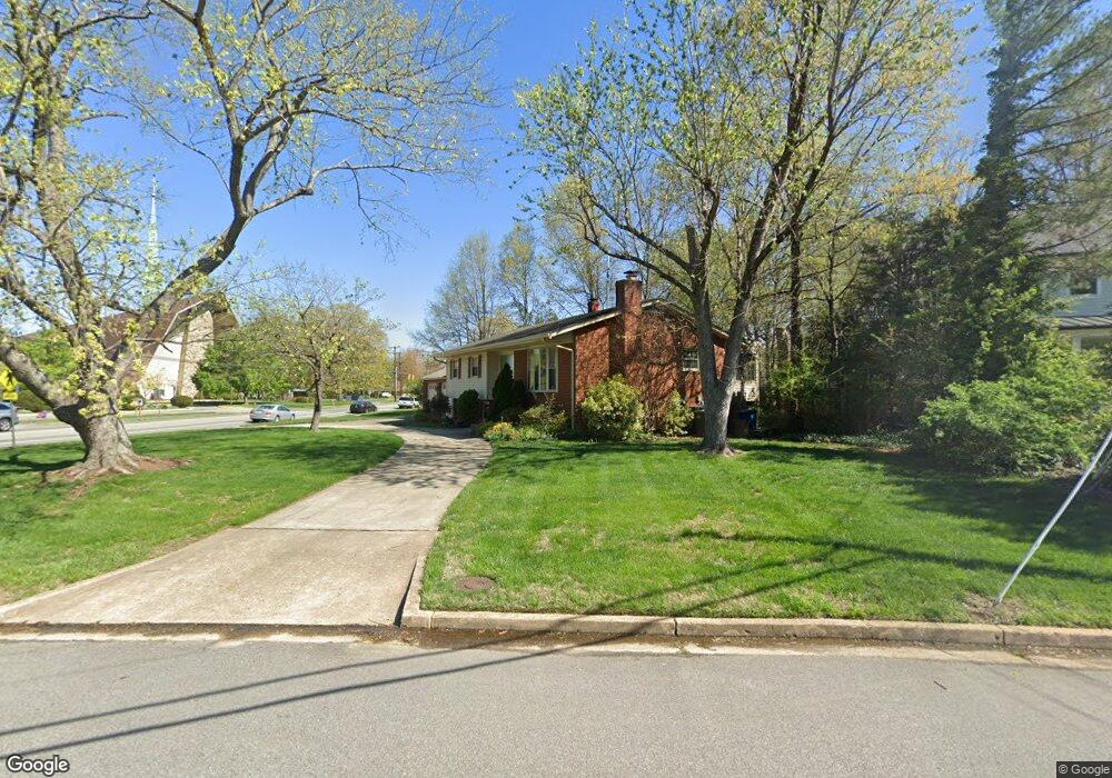
1230 Falster Rd Alexandria, VA 22308
Fort Hunt NeighborhoodEstimated Value: $835,000 - $884,027
4
Beds
3
Baths
1,388
Sq Ft
$622/Sq Ft
Est. Value
About This Home
This home is located at 1230 Falster Rd, Alexandria, VA 22308 and is currently estimated at $863,007, approximately $621 per square foot. 1230 Falster Rd is a home located in Fairfax County with nearby schools including Sandburg Middle, West Potomac High School, and The Aquinas Montessori School.
Ownership History
Date
Name
Owned For
Owner Type
Purchase Details
Closed on
Jun 15, 2006
Sold by
Meskunas Robert
Bought by
Oliver Alan P
Current Estimated Value
Home Financials for this Owner
Home Financials are based on the most recent Mortgage that was taken out on this home.
Original Mortgage
$417,000
Outstanding Balance
$245,436
Interest Rate
6.59%
Mortgage Type
New Conventional
Estimated Equity
$617,571
Create a Home Valuation Report for This Property
The Home Valuation Report is an in-depth analysis detailing your home's value as well as a comparison with similar homes in the area
Home Values in the Area
Average Home Value in this Area
Purchase History
| Date | Buyer | Sale Price | Title Company |
|---|---|---|---|
| Oliver Alan P | $585,000 | -- |
Source: Public Records
Mortgage History
| Date | Status | Borrower | Loan Amount |
|---|---|---|---|
| Open | Oliver Alan P | $417,000 |
Source: Public Records
Tax History Compared to Growth
Tax History
| Year | Tax Paid | Tax Assessment Tax Assessment Total Assessment is a certain percentage of the fair market value that is determined by local assessors to be the total taxable value of land and additions on the property. | Land | Improvement |
|---|---|---|---|---|
| 2025 | $9,581 | $782,090 | $372,000 | $410,090 |
| 2024 | $9,581 | $779,090 | $369,000 | $410,090 |
| 2023 | $9,282 | $779,090 | $369,000 | $410,090 |
| 2022 | $8,333 | $687,150 | $321,000 | $366,150 |
| 2021 | $8,252 | $669,150 | $303,000 | $366,150 |
| 2020 | $7,790 | $626,970 | $268,000 | $358,970 |
| 2019 | $7,277 | $582,380 | $250,000 | $332,380 |
| 2018 | $6,697 | $582,380 | $250,000 | $332,380 |
| 2017 | $7,106 | $582,380 | $250,000 | $332,380 |
| 2016 | $7,092 | $582,380 | $250,000 | $332,380 |
| 2015 | $6,658 | $565,700 | $243,000 | $322,700 |
| 2014 | $6,178 | $523,800 | $225,000 | $298,800 |
Source: Public Records
Map
Nearby Homes
- 8305 Fort Hunt Rd
- 8280 Colling Manor Ct
- 8276 Colling Manor Ct
- 8264 Colling Manor Ct
- 8281 Colling Manor Ct
- Hampton II Plan at Collingwood Chase
- 8260 Colling Manor Ct
- 1700 Collingwood Rd
- 8047 Fairfax Rd
- 8119 Stacey Rd
- 8123 Stacey Rd
- 8127 Stacey Rd
- 8118 Stacey Rd
- 8126 Stacey Rd
- 1600 Lafayette Dr
- 8602 Cushman Place
- 8601 Buckboard Dr
- 836 Herbert Springs Rd
- 8628 Plymouth Rd
- 8413 W Boulevard Dr
- 1228 Falster Rd
- 1229 Falster Rd
- 1226 Falster Rd
- 8310 Fort Hunt Rd
- 8314 Fort Hunt Rd
- 1135 Neal Dr
- 8301 Fort Hunt Rd
- 1224 Falster Rd
- 1223 Falster Rd
- 1137 Neal Dr
- 1203 Collingwood Rd
- 1222 Falster Rd
- 8315 Fort Hunt Rd
- 1301 Collingwood Rd
- 1221 Falster Rd
- 1133 Neal Dr
- 1201 Collingwood Rd
- 8316 Fort Hunt Rd
- 1220 Falster Rd
- 1208 Collingwood Rd