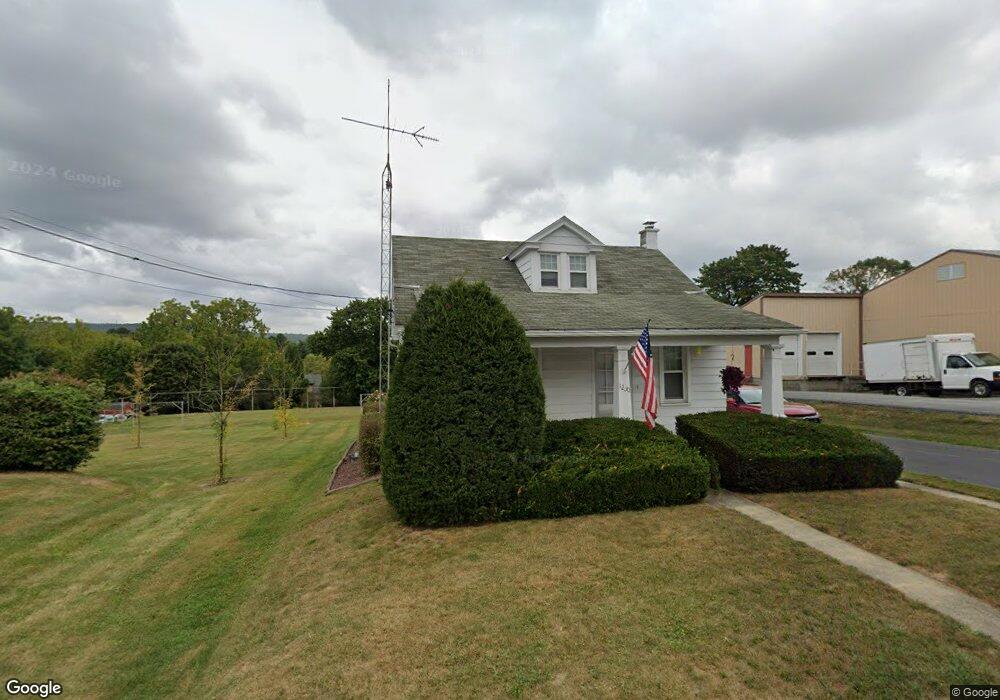
1230 Newport Rd Manheim, PA 17545
Estimated Value: $280,982 - $399,000
3
Beds
1
Bath
1,404
Sq Ft
$233/Sq Ft
Est. Value
About This Home
This home is located at 1230 Newport Rd, Manheim, PA 17545 and is currently estimated at $327,496, approximately $233 per square foot. 1230 Newport Rd is a home with nearby schools including Manheim Central Senior High School, Manheim Christian Day School, and New Haven Mennonite School.
Ownership History
Date
Name
Owned For
Owner Type
Purchase Details
Closed on
Aug 31, 2018
Sold by
Sauder Melvin W and Sauder Timothy N
Bought by
Sones Cherie
Current Estimated Value
Home Financials for this Owner
Home Financials are based on the most recent Mortgage that was taken out on this home.
Original Mortgage
$152,192
Outstanding Balance
$134,517
Interest Rate
5.25%
Mortgage Type
FHA
Estimated Equity
$192,979
Purchase Details
Closed on
Nov 2, 2009
Sold by
Sauder Dorothy H
Bought by
Sauder Melvin W and Sauder Timothy N
Create a Home Valuation Report for This Property
The Home Valuation Report is an in-depth analysis detailing your home's value as well as a comparison with similar homes in the area
Home Values in the Area
Average Home Value in this Area
Purchase History
| Date | Buyer | Sale Price | Title Company |
|---|---|---|---|
| Sones Cherie | $155,000 | Avenue 365 Lender Services L | |
| Sauder Melvin W | -- | None Available |
Source: Public Records
Mortgage History
| Date | Status | Borrower | Loan Amount |
|---|---|---|---|
| Open | Sones Cherie | $152,192 |
Source: Public Records
Tax History Compared to Growth
Tax History
| Year | Tax Paid | Tax Assessment Tax Assessment Total Assessment is a certain percentage of the fair market value that is determined by local assessors to be the total taxable value of land and additions on the property. | Land | Improvement |
|---|---|---|---|---|
| 2025 | $2,887 | $141,600 | $43,800 | $97,800 |
| 2024 | $2,887 | $141,600 | $43,800 | $97,800 |
| 2023 | $2,826 | $141,600 | $43,800 | $97,800 |
| 2022 | $2,753 | $141,600 | $43,800 | $97,800 |
| 2021 | $2,691 | $141,600 | $43,800 | $97,800 |
| 2020 | $2,691 | $141,600 | $43,800 | $97,800 |
| 2019 | $2,644 | $141,600 | $43,800 | $97,800 |
| 2018 | $2,029 | $141,600 | $43,800 | $97,800 |
| 2017 | $3,254 | $139,600 | $33,500 | $106,100 |
| 2016 | $3,254 | $139,600 | $33,500 | $106,100 |
| 2015 | $773 | $139,600 | $33,500 | $106,100 |
| 2014 | $2,399 | $139,600 | $33,500 | $106,100 |
Source: Public Records
Map
Nearby Homes
- 1430 N Penryn Rd
- 1505 Newport Rd
- 809 W Brubaker Valley Rd
- 655 White Oak Rd
- 732 Heather Ridge Unit 147
- 616 Auburn Dr Unit 190
- 758 Heather Ridge Unit 158
- 461 Thrush Dr
- 981 Cambridge Dr
- 421 Rosewood Dr
- 554 Mallard Dr
- 8 Penn Valley Village
- 90 Penn Valley Village
- 609 Hamaker Rd
- 2891 Newport Rd
- 310 W Lexington Rd
- 1217 Lebanon Rd
- 1227 Lebanon Rd
- 1159 Lebanon Rd
- 212 Weaver Dr
- 1229 Newport Rd
- 1223 Newport Rd
- 1235 Newport Rd
- 1217 Newport Rd
- 1211 Newport Rd
- 1247 Newport Rd
- 1251 Newport Rd
- 1261 Newport Rd
- 1416 N Penryn Rd
- 1195 Newport Rd
- 1415 N Penryn Rd
- 1446 Picnic Grove Rd
- 1283 Newport Rd
- 1173 Newport Rd
- 1367 N Penryn Rd
- 1163 Newport Rd
- 1291 Newport Rd
- 1158 Newport Rd
- 1297 Newport Rd
- 1344 N Penryn Rd