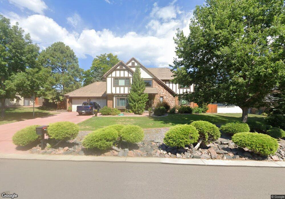
12305 W 54th Dr Arvada, CO 80002
Rainbow Ridge NeighborhoodEstimated Value: $897,658 - $1,071,000
4
Beds
5
Baths
2,979
Sq Ft
$321/Sq Ft
Est. Value
About This Home
This home is located at 12305 W 54th Dr, Arvada, CO 80002 and is currently estimated at $955,665, approximately $320 per square foot. 12305 W 54th Dr is a home located in Jefferson County with nearby schools including Vanderhoof Elementary School, Drake Junior High School, and Arvada West High School.
Ownership History
Date
Name
Owned For
Owner Type
Purchase Details
Closed on
Jun 15, 2017
Sold by
Norton Steven and Norton Kathleen
Bought by
The Norton Family Trust
Current Estimated Value
Purchase Details
Closed on
May 31, 1994
Sold by
Antonopulos Stephen L and Antonopulos Kathleen A
Bought by
Norton Steven and Norton Kathleen
Home Financials for this Owner
Home Financials are based on the most recent Mortgage that was taken out on this home.
Original Mortgage
$203,150
Interest Rate
8.45%
Create a Home Valuation Report for This Property
The Home Valuation Report is an in-depth analysis detailing your home's value as well as a comparison with similar homes in the area
Home Values in the Area
Average Home Value in this Area
Purchase History
| Date | Buyer | Sale Price | Title Company |
|---|---|---|---|
| The Norton Family Trust | -- | None Available | |
| Norton Steven | $263,000 | First American Heritage Titl |
Source: Public Records
Mortgage History
| Date | Status | Borrower | Loan Amount |
|---|---|---|---|
| Closed | Norton Steven | $203,150 |
Source: Public Records
Tax History Compared to Growth
Tax History
| Year | Tax Paid | Tax Assessment Tax Assessment Total Assessment is a certain percentage of the fair market value that is determined by local assessors to be the total taxable value of land and additions on the property. | Land | Improvement |
|---|---|---|---|---|
| 2024 | $4,606 | $55,525 | $26,174 | $29,351 |
| 2023 | $4,606 | $55,525 | $26,174 | $29,351 |
| 2022 | $3,904 | $47,941 | $19,470 | $28,471 |
| 2021 | $3,966 | $49,321 | $20,030 | $29,291 |
| 2020 | $3,538 | $44,807 | $17,008 | $27,799 |
| 2019 | $3,490 | $44,807 | $17,008 | $27,799 |
| 2018 | $4,387 | $46,031 | $12,639 | $33,392 |
| 2017 | $4,008 | $46,031 | $12,639 | $33,392 |
| 2016 | $3,790 | $40,787 | $12,585 | $28,202 |
| 2015 | $3,676 | $42,984 | $12,585 | $30,399 |
| 2014 | $3,676 | $37,249 | $11,411 | $25,838 |
Source: Public Records
Map
Nearby Homes
- 5555 Ward Rd
- 11873 W 56th Cir
- 5173 Vivian St
- 5188 Ward Rd
- 5160 Ward Rd
- 5738 Vivian St
- 5738 Urban Center
- 5154 Taft Ct
- 12320 W 51st Ave
- 12284 W 57th Ln
- 11958 W 57th Place
- 11944 W 57th Dr
- 11924 W 57th Dr
- The SIXTEEN Plan at Sabell - Townhomes
- The NINETEEN Plan at Sabell - Townhomes
- 5779 Taft St
- 5240 Routt Ct Unit B
- 5795 Xenon Way
- Haskins Station Plan at Haskins Station
- Plan 133 at Haskins Station
- 12295 W 54th Dr
- 5445 Vivian Cir
- 12288 W 54th Dr
- 12285 W 54th Dr
- 12318 W 54th Dr
- 5436 Vivian Cir
- 12278 W 54th Dr
- 5435 Vivian Cir
- 5462 Colorado 72
- 12275 W 54th Dr
- 12355 W 54th Dr
- 12120 W 54th Ave
- 5426 Vivian Cir
- 5425 Vivian Cir
- 5400 Ward Rd Unit 1
- 5395 Union Way
- 12121 W 54th Ave
- 5385 Union Way
- 12167 W 54th Dr
- 5375 Union Way