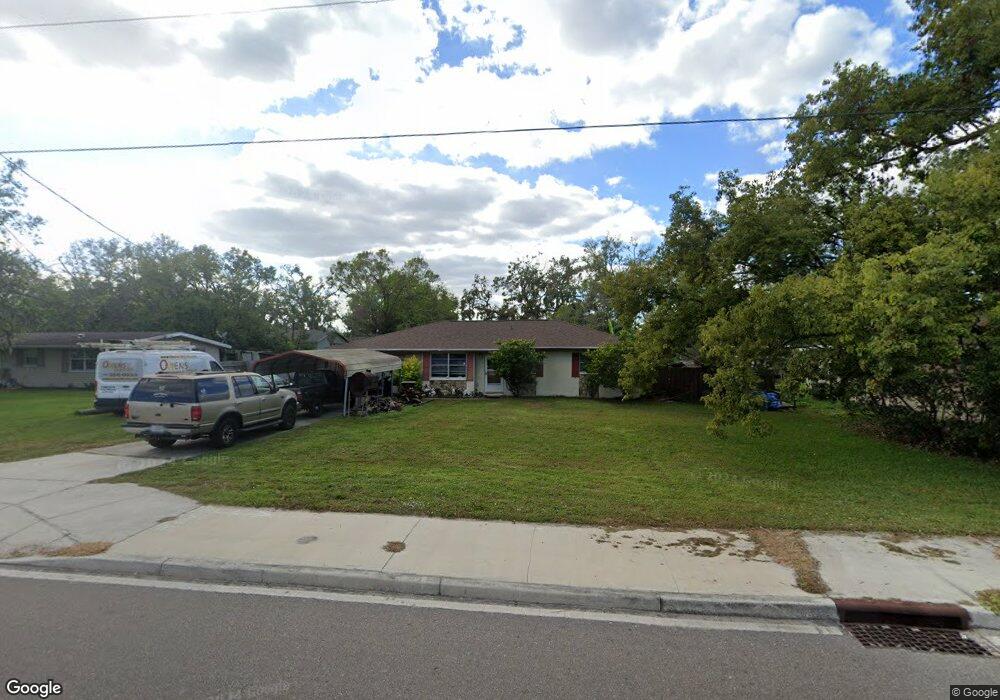
12308 Us Highway 301 N Parrish, FL 34219
Estimated Value: $265,867 - $1,232,000
2
Beds
2
Baths
1,224
Sq Ft
$421/Sq Ft
Est. Value
About This Home
This home is located at 12308 Us Highway 301 N, Parrish, FL 34219 and is currently estimated at $515,717, approximately $421 per square foot. 12308 Us Highway 301 N is a home located in Manatee County with nearby schools including Barbara A. Harvey Elementary School, Buffalo Creek Middle School, and Parrish Community High School.
Ownership History
Date
Name
Owned For
Owner Type
Purchase Details
Closed on
Mar 21, 2006
Sold by
Huseby Michele and Michele Huseby Revocable Trust
Bought by
Parks James E
Current Estimated Value
Purchase Details
Closed on
Dec 3, 2004
Sold by
Muisener Donald K and Muisener June D
Bought by
Huseby Michele
Home Financials for this Owner
Home Financials are based on the most recent Mortgage that was taken out on this home.
Original Mortgage
$114,750
Interest Rate
5.87%
Mortgage Type
Purchase Money Mortgage
Create a Home Valuation Report for This Property
The Home Valuation Report is an in-depth analysis detailing your home's value as well as a comparison with similar homes in the area
Home Values in the Area
Average Home Value in this Area
Purchase History
| Date | Buyer | Sale Price | Title Company |
|---|---|---|---|
| Parks James E | $130,000 | Attorney | |
| Huseby Michele | -- | Attorney | |
| Huseby Michele | $153,000 | -- |
Source: Public Records
Mortgage History
| Date | Status | Borrower | Loan Amount |
|---|---|---|---|
| Previous Owner | Huseby Michele | $114,750 |
Source: Public Records
Tax History
| Year | Tax Paid | Tax Assessment Tax Assessment Total Assessment is a certain percentage of the fair market value that is determined by local assessors to be the total taxable value of land and additions on the property. | Land | Improvement |
|---|---|---|---|---|
| 2025 | $2,700 | $187,275 | -- | -- |
| 2023 | $2,700 | $196,350 | $27,961 | $168,389 |
| 2022 | $2,472 | $176,633 | $29,359 | $147,274 |
| 2021 | $1,104 | $127,912 | $29,359 | $98,553 |
| 2020 | $1,985 | $122,807 | $25,218 | $97,589 |
| 2019 | $2,005 | $124,119 | $25,218 | $98,901 |
| 2018 | $1,844 | $111,534 | $16,810 | $94,724 |
| 2017 | $883 | $104,127 | $0 | $0 |
| 2016 | $870 | $100,224 | $0 | $0 |
Source: Public Records
Map
Nearby Homes
- 12346 U S 301
- 12300 Parrish Cemetary Rd
- 12310 Oak Hill Way
- 12342 Oak Hill Way
- 12350 Oak Hill Way
- 12358 Oak Hill Way
- 12362 Oak Hill Way
- 12369 Oak Hill Way
- 12366 Oak Hill Way
- 12373 Oak Hill Way
- 12377 Oak Hill Way
- 12374 Oak Hill Way
- 8814 Bahama Mia Ln
- 7121 122nd Ave E
- 11955 Richmond Trail
- 11809 Catawba Cove
- 11963 Richmond Trail
- 11908 Richmond Trail
- 11892 Richmond Trail
- 8514 Arrow Creek Dr
- 12312 Us Highway 301 N
- 12302 Us Highway 301 N
- 12314 Us Highway 301 N
- 7814 122nd Ave E
- 7904 122nd Ave E
- 7808 122nd Ave E
- 7912 122nd Ave E
- 12294 Us Highway 301 N
- 7807 122nd Ave E
- 7811 122nd Ave E
- 7805 122nd Ave E
- 7903 122nd Ave E
- 7909 122nd Ave E
- 7731 122nd Ave E
- 12125 78th St E
- 12120 78th St E
- 7915 122nd Ave E
- 7711 122nd Ave E
- 7850 121st Ave E
Your Personal Tour Guide
Ask me questions while you tour the home.