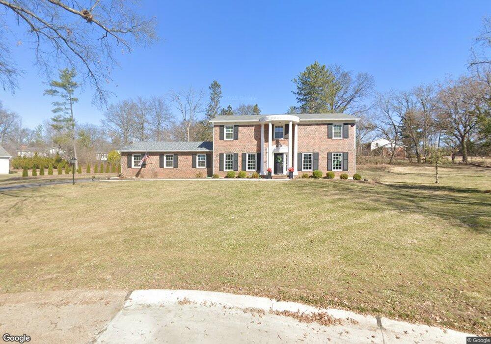
12309 Borcherding Ln Saint Louis, MO 63131
Estimated Value: $753,000 - $1,201,000
4
Beds
4
Baths
2,752
Sq Ft
$324/Sq Ft
Est. Value
About This Home
This home is located at 12309 Borcherding Ln, Saint Louis, MO 63131 and is currently estimated at $892,784, approximately $324 per square foot. 12309 Borcherding Ln is a home located in St. Louis County with nearby schools including Westchester Elementary School, North Kirkwood Middle School, and Kirkwood Senior High School.
Ownership History
Date
Name
Owned For
Owner Type
Purchase Details
Closed on
Nov 27, 2024
Sold by
Evola Joseph A and Evola Elizabeth A
Bought by
Evola Revocable Trust
Current Estimated Value
Purchase Details
Closed on
Apr 3, 2021
Sold by
Ziwot Deborah Ann and Ziwot Frederick Paul
Bought by
Evola Joseph A and Evola Elizabeth A
Create a Home Valuation Report for This Property
The Home Valuation Report is an in-depth analysis detailing your home's value as well as a comparison with similar homes in the area
Home Values in the Area
Average Home Value in this Area
Purchase History
| Date | Buyer | Sale Price | Title Company |
|---|---|---|---|
| Evola Revocable Trust | -- | None Listed On Document | |
| Evola Revocable Trust | -- | None Listed On Document | |
| Evola Joseph A | $508,000 | Orntic St Louis |
Source: Public Records
Tax History
| Year | Tax Paid | Tax Assessment Tax Assessment Total Assessment is a certain percentage of the fair market value that is determined by local assessors to be the total taxable value of land and additions on the property. | Land | Improvement |
|---|---|---|---|---|
| 2025 | $6,239 | $126,010 | $79,020 | $46,990 |
| 2024 | $6,239 | $107,860 | $64,200 | $43,660 |
| 2023 | $5,867 | $103,000 | $64,200 | $38,800 |
| 2022 | $5,883 | $96,270 | $64,200 | $32,070 |
| 2021 | $5,820 | $96,270 | $64,200 | $32,070 |
| 2020 | $5,741 | $91,300 | $37,720 | $53,580 |
| 2019 | $5,748 | $91,300 | $37,720 | $53,580 |
| 2018 | $5,218 | $74,330 | $28,840 | $45,490 |
| 2017 | $5,232 | $74,330 | $28,840 | $45,490 |
| 2016 | $4,734 | $68,090 | $28,840 | $39,250 |
Source: Public Records
Map
Nearby Homes
- TBB
- TBB Ballas Ridge Roclare II
- The Hawthorne Plan at Ballas Ridge
- The Roclare II Plan at Ballas Ridge
- The Westchester IV Plan at Ballas Ridge
- 2030 N Ballas Rd
- The Nottingham II Plan at Ballas Ridge
- The Hawthorne II Plan at Ballas Ridge
- TBB Ballas Ridge Hawthorne II
- TBB Ballas Ridge Westchester IV
- 12439 Springdale Ln Unit TBB
- TBB
- 2056 N Ballas Rd
- 2062 N Ballas Rd
- 12044 Carberry Place
- 1319 Kendon Dr
- 1741 Pine Hill Dr
- 0 Unknown Unit 22071090
- 1126 Bopp Rd
- 1534 Woodgate Dr
- 12302 Ironstone Rd
- 12300 Borcherding Ln
- 12315 Borcherding Ln
- 12310 Ironstone Rd
- 12306 Borcherding Ln
- 12312 Borcherding Ln
- 1850 Ironstone Rd
- 1837 Candlewick Dr
- 1839 Candlewick Dr
- 12321 Borcherding Ln
- 12322 Ironstone Rd
- 12318 Borcherding Ln
- 1855 Ironstone Rd
- 12131 Creekhaven Dr
- 1815 Candlewick Dr
- 1851 Candlewick Dr
- 1856 Ironstone Rd
- 12117 Creekhaven Dr
- 12319 Ironstone Rd
- 12311 Creekhaven Dr
Your Personal Tour Guide
Ask me questions while you tour the home.