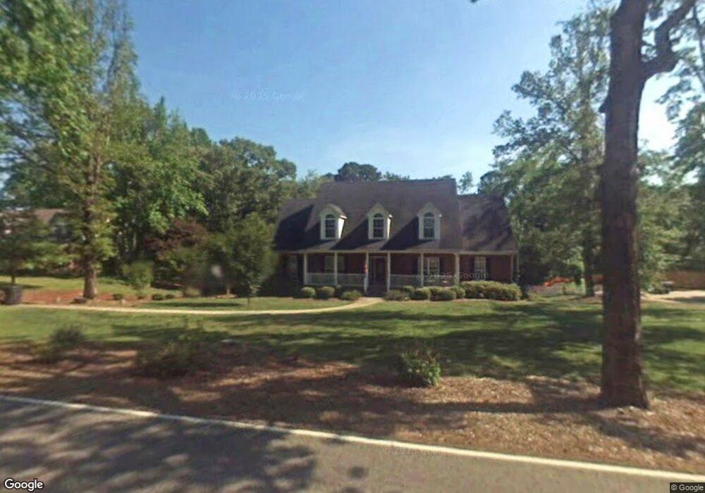
1231 Al Seier Rd Hoover, AL 35226
Estimated Value: $557,000 - $645,000
4
Beds
4
Baths
4,193
Sq Ft
$145/Sq Ft
Est. Value
About This Home
This home is located at 1231 Al Seier Rd, Hoover, AL 35226 and is currently estimated at $606,550, approximately $144 per square foot. 1231 Al Seier Rd is a home located in Jefferson County with nearby schools including Trace Crossings Elementary School, Ira F. Simmons Middle School, and Hoover High School.
Ownership History
Date
Name
Owned For
Owner Type
Purchase Details
Closed on
Jan 30, 2024
Sold by
Emery Michael J
Bought by
Overton Savannah Llc
Current Estimated Value
Purchase Details
Closed on
Jul 3, 2001
Sold by
Holcombe Steve
Bought by
Emery Michael J and Emery Andrea R
Home Financials for this Owner
Home Financials are based on the most recent Mortgage that was taken out on this home.
Original Mortgage
$189,000
Interest Rate
7.17%
Purchase Details
Closed on
Oct 1, 1999
Sold by
Jackson Kenneth M and Jackson Adrienne L
Bought by
Emery Michael J and Emery Andrea
Home Financials for this Owner
Home Financials are based on the most recent Mortgage that was taken out on this home.
Original Mortgage
$32,175
Interest Rate
7.79%
Create a Home Valuation Report for This Property
The Home Valuation Report is an in-depth analysis detailing your home's value as well as a comparison with similar homes in the area
Home Values in the Area
Average Home Value in this Area
Purchase History
| Date | Buyer | Sale Price | Title Company |
|---|---|---|---|
| Overton Savannah Llc | $214,400 | -- | |
| Emery Michael J | $238,775 | -- | |
| Emery Michael J | $43,900 | -- |
Source: Public Records
Mortgage History
| Date | Status | Borrower | Loan Amount |
|---|---|---|---|
| Previous Owner | Emery Michael J | $189,000 | |
| Previous Owner | Emery Michael J | $32,175 |
Source: Public Records
Tax History Compared to Growth
Tax History
| Year | Tax Paid | Tax Assessment Tax Assessment Total Assessment is a certain percentage of the fair market value that is determined by local assessors to be the total taxable value of land and additions on the property. | Land | Improvement |
|---|---|---|---|---|
| 2024 | $3,358 | $51,580 | -- | -- |
| 2022 | $3,496 | $48,870 | $13,910 | $34,960 |
| 2021 | $3,170 | $44,400 | $13,910 | $30,490 |
| 2020 | $2,947 | $41,180 | $13,910 | $27,270 |
| 2019 | $2,757 | $38,700 | $0 | $0 |
| 2018 | $1,970 | $27,860 | $0 | $0 |
| 2017 | $1,970 | $27,860 | $0 | $0 |
| 2016 | $1,970 | $27,860 | $0 | $0 |
| 2015 | $1,970 | $27,860 | $0 | $0 |
| 2014 | $2,067 | $29,200 | $0 | $0 |
| 2013 | $2,067 | $28,480 | $0 | $0 |
Source: Public Records
Map
Nearby Homes
- 3505 Atwillher Dr
- 622 Preserve Way
- 3583 Burnt Leaf Ln Unit 2
- 625 Founders Park Dr W
- 637 Preserve Way
- 4192 Memorial Park Cir
- 189 Highland Crest Pkwy
- 634 Preserve Pkwy
- 622 Preserve Pkwy
- 4391 Village Green Cir
- 472 Preserve Pkwy
- 460 Preserve Pkwy
- 462 Preserve Pkwy
- 466 Preserve Pkwy
- 474 Preserve Pkwy
- 545 Oakline Dr
- 586 Preserve Way
- 583 Preserve Way
- 4515 Village Green Way
- 4437 Village Green Cir
- 1227 Al Seier Rd
- 1235 Al Seier Rd
- 1225 Al Seier Rd
- 682 Founders Park Dr W
- 678 Founders Park Dr W
- 672 Founders Park Dr W
- 1223 Al Seier Rd
- 686 Founders Park Dr W
- 668 Founders Park Dr W
- 3539 Burntleaf Ln
- 3535 Burntleaf Ln
- 3518 Atdoann Dr
- 1243 Al Seier Rd
- 4498 Heritage Park Dr
- 3547 Burntleaf Ln
- 690 Founders Park Dr W
- 677 Founders Park Dr W
- 690 Founders Park Dr
- 662 Founders Park Dr W
- 3522 Atdoann Dr