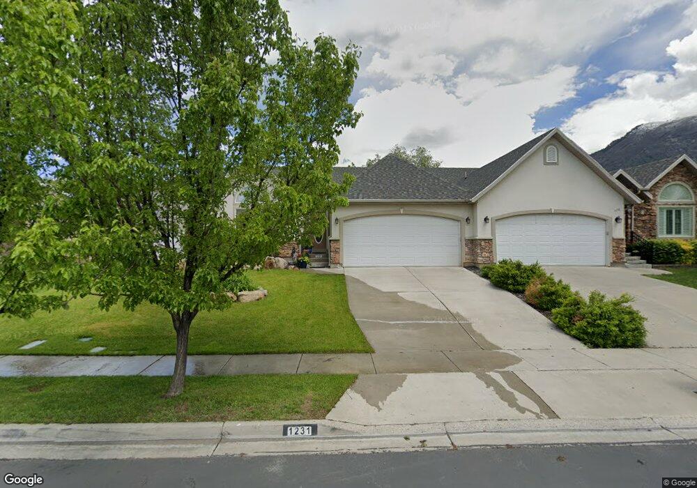
1231 E 1350 N Unit 43 American Fork, UT 84003
Estimated Value: $636,000 - $677,000
4
Beds
3
Baths
1,917
Sq Ft
$344/Sq Ft
Est. Value
About This Home
This home is located at 1231 E 1350 N Unit 43, American Fork, UT 84003 and is currently estimated at $659,506, approximately $344 per square foot. 1231 E 1350 N Unit 43 is a home located in Utah County with nearby schools including Deerfield Elementary School, Mountain Ridge Junior High School, and American Fork High School.
Ownership History
Date
Name
Owned For
Owner Type
Purchase Details
Closed on
Oct 2, 2020
Sold by
Brown Analee and Brown Lane
Bought by
Brown Lane and Brown Analee
Current Estimated Value
Purchase Details
Closed on
Dec 8, 2010
Sold by
Jpmorgan Chase Bank National Association
Bought by
Hall Alan J and Hall Anita L
Purchase Details
Closed on
Aug 16, 2010
Sold by
Thoman Debra C
Bought by
Jpmorgan Chase Bank National Association
Purchase Details
Closed on
Jun 6, 2007
Sold by
Forest Grove Holdings Llc
Bought by
Thoman Debra C
Purchase Details
Closed on
Apr 14, 2005
Sold by
Olsen Michael E
Bought by
Thoman Debra
Home Financials for this Owner
Home Financials are based on the most recent Mortgage that was taken out on this home.
Original Mortgage
$168,800
Interest Rate
5.77%
Mortgage Type
Fannie Mae Freddie Mac
Purchase Details
Closed on
Apr 12, 2005
Sold by
Thoman Debra
Bought by
Thoman Debra C
Home Financials for this Owner
Home Financials are based on the most recent Mortgage that was taken out on this home.
Original Mortgage
$168,800
Interest Rate
5.77%
Mortgage Type
Fannie Mae Freddie Mac
Purchase Details
Closed on
May 31, 2002
Sold by
Olsen Brad M
Bought by
Olsen Michael E
Purchase Details
Closed on
Oct 17, 2000
Sold by
American Springs Development Company Llc
Bought by
Olsen Brad M
Create a Home Valuation Report for This Property
The Home Valuation Report is an in-depth analysis detailing your home's value as well as a comparison with similar homes in the area
Home Values in the Area
Average Home Value in this Area
Purchase History
| Date | Buyer | Sale Price | Title Company |
|---|---|---|---|
| Brown Lane | -- | None Available | |
| Hall Alan J | -- | Metro National Title | |
| Jpmorgan Chase Bank National Association | $256,324 | None Available | |
| Thoman Debra C | -- | First American Title Pine | |
| Forest Grove Holdings Llc | -- | Accommodation | |
| Thoman Debra | -- | Mountain West Title Company | |
| Thoman Debra C | -- | Mountain West Title Company | |
| Olsen Michael E | -- | Mountain West Title Co | |
| Olsen Brad M | -- | Signature Title |
Source: Public Records
Mortgage History
| Date | Status | Borrower | Loan Amount |
|---|---|---|---|
| Previous Owner | Thoman Debra | $168,800 | |
| Previous Owner | Thoman Debra C | $42,200 |
Source: Public Records
Tax History
| Year | Tax Paid | Tax Assessment Tax Assessment Total Assessment is a certain percentage of the fair market value that is determined by local assessors to be the total taxable value of land and additions on the property. | Land | Improvement |
|---|---|---|---|---|
| 2025 | $3,045 | $352,770 | -- | -- |
| 2024 | $3,045 | $338,360 | $0 | $0 |
| 2023 | $2,862 | $337,150 | $0 | $0 |
| 2022 | $2,439 | $283,525 | $0 | $0 |
| 2021 | $2,184 | $396,500 | $105,000 | $291,500 |
| 2020 | $2,124 | $374,100 | $105,000 | $269,100 |
| 2019 | $1,905 | $347,000 | $105,000 | $242,000 |
| 2018 | $1,992 | $347,000 | $105,000 | $242,000 |
| 2017 | $1,707 | $160,435 | $0 | $0 |
| 2016 | $1,546 | $134,970 | $0 | $0 |
| 2015 | $1,573 | $130,350 | $0 | $0 |
| 2014 | $1,446 | $118,250 | $0 | $0 |
Source: Public Records
Map
Nearby Homes
- 9587 N 4500 W
- 1125 N 1270 E
- 3518 N 1450 W
- 4675 W Ferguson Way
- 9752 N Dorchester Dr
- 4552 W Windsor Cir
- 4531 W Cambridge Dr
- 1077 N 950 E
- 1045 N 930 E Unit 58
- 9506 N 4000 W
- 4979 W Willowbank Dr
- 4968 W Evergreen Ln
- 5032 W Northwood Ln
- 5061 W Evergreen Ln
- 9481 N 3830 W
- 4814 W Washoe Ct
- 4956 W Gallatin Way
- 3810 W Valley View Dr
- 9547 N Canyon Rd
- 5034 W Green Ash Ln
- 1231 E 1350 N
- 1229 E 1350 N
- 1229 E 1350 N Unit 42
- 1233 E 1350 N
- 1233 E 1350 N Unit 44
- 1245 E 1350 N
- 1245 E 1350 N Unit TWIN
- 1227 E 1350 N
- 1227 E 1350 N Unit 41
- 1226 Murdock Dr
- 1244 Murdock Dr
- 1224 Murdock Dr
- 1247 E 1350 N Unit 46
- 1247 E 1350 N
- 1246 Murdock Dr
- 1215 E 1350 N
- 1215 E 1350 N Unit 40
- 1230 E 1350 N
- 1226 E 1350 N
- 1208 Murdock Dr
Your Personal Tour Guide
Ask me questions while you tour the home.