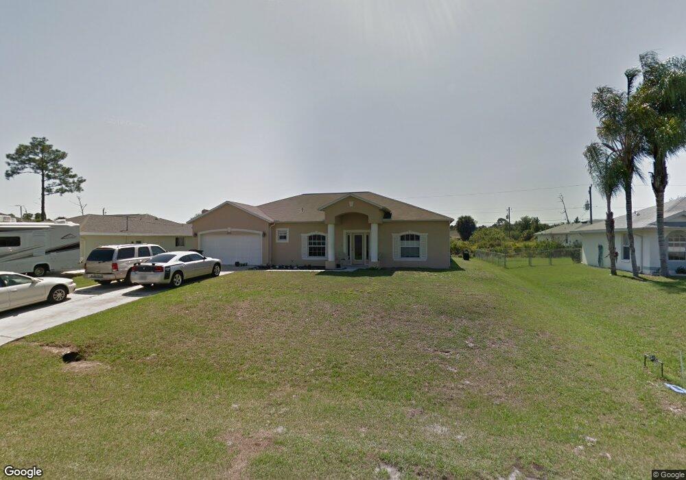
1231 Mccrory St North Port, FL 34286
Estimated Value: $363,000 - $464,000
4
Beds
3
Baths
2,304
Sq Ft
$177/Sq Ft
Est. Value
About This Home
This home is located at 1231 Mccrory St, North Port, FL 34286 and is currently estimated at $407,062, approximately $176 per square foot. 1231 Mccrory St is a home located in Sarasota County with nearby schools including Toledo Blade Elementary School, North Port High School, and Woodland Middle School.
Ownership History
Date
Name
Owned For
Owner Type
Purchase Details
Closed on
Jun 14, 2002
Sold by
Holiday Bldr Inc
Bought by
King Brian M and King Allison R
Current Estimated Value
Home Financials for this Owner
Home Financials are based on the most recent Mortgage that was taken out on this home.
Original Mortgage
$130,508
Outstanding Balance
$55,026
Interest Rate
6.77%
Mortgage Type
FHA
Estimated Equity
$352,036
Purchase Details
Closed on
Jan 3, 2002
Sold by
Dey Floyd M and Dey Mary Nell
Bought by
Holiday Bldr Inc
Purchase Details
Closed on
Apr 27, 2000
Sold by
Dey Floyd M and Dey Mary Nell
Bought by
Delaney Lois
Create a Home Valuation Report for This Property
The Home Valuation Report is an in-depth analysis detailing your home's value as well as a comparison with similar homes in the area
Home Values in the Area
Average Home Value in this Area
Purchase History
| Date | Buyer | Sale Price | Title Company |
|---|---|---|---|
| King Brian M | $131,600 | -- | |
| Holiday Bldr Inc | $5,000 | -- | |
| Delaney Lois | $6,000 | -- |
Source: Public Records
Mortgage History
| Date | Status | Borrower | Loan Amount |
|---|---|---|---|
| Open | King Brian M | $130,508 |
Source: Public Records
Tax History Compared to Growth
Tax History
| Year | Tax Paid | Tax Assessment Tax Assessment Total Assessment is a certain percentage of the fair market value that is determined by local assessors to be the total taxable value of land and additions on the property. | Land | Improvement |
|---|---|---|---|---|
| 2024 | $3,038 | $192,758 | -- | -- |
| 2023 | $3,038 | $187,144 | $0 | $0 |
| 2022 | $2,562 | $154,703 | $0 | $0 |
| 2021 | $2,520 | $150,197 | $0 | $0 |
| 2020 | $2,507 | $148,123 | $0 | $0 |
| 2019 | $2,389 | $144,793 | $0 | $0 |
| 2018 | $2,237 | $142,093 | $0 | $0 |
| 2017 | $2,189 | $139,170 | $0 | $0 |
| 2016 | $2,185 | $197,000 | $5,200 | $191,800 |
| 2015 | $2,210 | $167,000 | $4,700 | $162,300 |
| 2014 | $2,174 | $132,301 | $0 | $0 |
Source: Public Records
Map
Nearby Homes
- 1081 Mccrory St
- 0 Altoona Ave Unit MFRA4653713
- 2179 W Price Blvd
- 1022 S Lavina St
- 1480 Wise Dr
- 0 Wyola Ave Unit MFRC7507151
- 0 Low St
- 0 Trilby Ave Unit R11102643
- 0 Manheim Ave Unit MFRD6144455
- 0 Yacolt Ave Unit MFRA4665223
- 2415 W Price Blvd
- 1372 Vendome Terrace
- 0 Ruiz St Unit MFRC7506881
- 0 Pilger Ave Unit MFRC7512574
- 0 Snover Ave
- 2293 Pilger Ave
- 0 Sareta Terrace Unit MFRO6170144
- 1956 Snover Ave
- 0 Marconi Ave
- 2471 W Price Blvd
- 1211 Mccrory St
- 1251 Mccrory St
- 1222 Arredondo St
- 1230 Mccrory St
- 1181 Mccrory St
- 1198 Arredondo St
- 1270 Arredondo St
- 1198 Street
- 1250 Mccrory St
- 1190 Mccrory St
- 0 Arredondo St
- 1270 Mccrory St
- 1150 Arredondo St
- 1161 Mccrory St
- 1291 Mccrory St
- 1290 Mccrory St
- 1339 N Chamberlain Blvd
- 1369 N Chamberlain Blvd
- 1219 Arredondo St
- 1245 Arredondo St