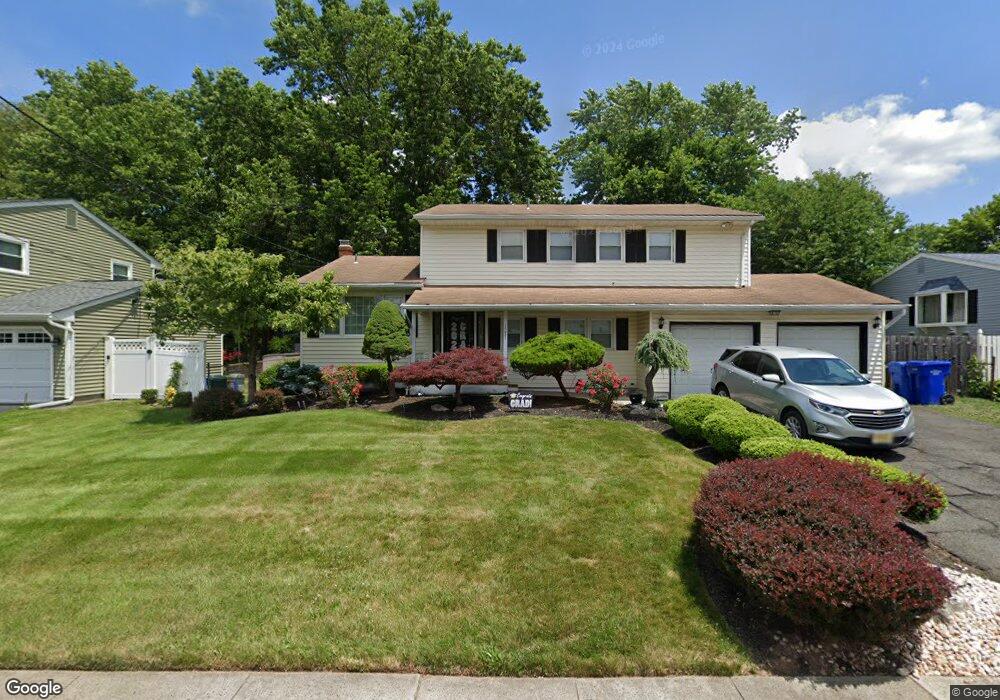
1231 Omaha Rd North Brunswick, NJ 08902
Estimated Value: $634,000
4
Beds
3
Baths
2,074
Sq Ft
$306/Sq Ft
Est. Value
About This Home
This home is located at 1231 Omaha Rd, North Brunswick, NJ 08902 and is currently estimated at $634,000, approximately $305 per square foot. 1231 Omaha Rd is a home located in Middlesex County with nearby schools including John Adams Elementary School, Linwood Middle School, and North Brunswick Twp High School.
Ownership History
Date
Name
Owned For
Owner Type
Purchase Details
Closed on
Sep 25, 2008
Sold by
Amponsah Daniel and Amponsah Cynthia M
Current Estimated Value
Home Financials for this Owner
Home Financials are based on the most recent Mortgage that was taken out on this home.
Original Mortgage
$382,922
Outstanding Balance
$255,975
Interest Rate
6.54%
Mortgage Type
FHA
Estimated Equity
$378,025
Purchase Details
Closed on
Sep 29, 2000
Sold by
Franco Katerine Costello
Bought by
Amponsah Daniel and Amponsah Cynthia
Home Financials for this Owner
Home Financials are based on the most recent Mortgage that was taken out on this home.
Original Mortgage
$204,200
Interest Rate
7.89%
Create a Home Valuation Report for This Property
The Home Valuation Report is an in-depth analysis detailing your home's value as well as a comparison with similar homes in the area
Home Values in the Area
Average Home Value in this Area
Purchase History
| Date | Buyer | Sale Price | Title Company |
|---|---|---|---|
| -- | $385,000 | Nj Title Insurance Company | |
| Amponsah Daniel | $215,000 | -- |
Source: Public Records
Mortgage History
| Date | Status | Borrower | Loan Amount |
|---|---|---|---|
| Open | -- | $382,922 | |
| Previous Owner | Amponsah Daniel | $204,200 |
Source: Public Records
Tax History Compared to Growth
Tax History
| Year | Tax Paid | Tax Assessment Tax Assessment Total Assessment is a certain percentage of the fair market value that is determined by local assessors to be the total taxable value of land and additions on the property. | Land | Improvement |
|---|---|---|---|---|
| 2025 | $11,050 | $174,400 | $59,000 | $115,400 |
| 2024 | $10,851 | $174,400 | $59,000 | $115,400 |
| 2023 | $10,851 | $174,400 | $59,000 | $115,400 |
| 2022 | $10,481 | $174,400 | $59,000 | $115,400 |
| 2021 | $7,637 | $174,400 | $59,000 | $115,400 |
| 2020 | $10,091 | $174,400 | $59,000 | $115,400 |
| 2019 | $9,885 | $174,400 | $59,000 | $115,400 |
| 2018 | $9,683 | $174,400 | $59,000 | $115,400 |
| 2017 | $9,512 | $174,400 | $59,000 | $115,400 |
| 2016 | $9,313 | $174,400 | $59,000 | $115,400 |
| 2015 | $9,154 | $174,400 | $59,000 | $115,400 |
| 2014 | $9,051 | $174,400 | $59,000 | $115,400 |
Source: Public Records
Map
Nearby Homes
- 1209 Dakota Rd
- 1464 Columbia Dr
- 1365 Sioux Rd
- 210 N Oaks Blvd Unit 210
- 1010 N Oaks Blvd
- 1632 Hudson Ave
- 5208 N Oaks Blvd
- 1133 Livingston Ave Unit 11C
- 936 Patton St
- 1314 N Oaks Blvd
- 1499 La Rose Ave
- 1078 Newton St
- 89 Pennsylvania Way
- 1067 Grove St
- 63 Pennsylvania Way
- 3807 Birchwood Ct
- 32 Lafayette Ct
- 3910 Birchwood Ct
- 224 Pennsylvania Way
- 4511 Birchwood Ct
- 1237 Omaha Rd
- 1223 Omaha Rd
- 1226 W Peoria Place
- 1218 W Peoria Place
- 1245 Omaha Rd
- 1215 Omaha Rd
- 1426 Mullica Dr
- 1393 Peoria Place
- 1246 Omaha Rd
- 1212 W Peoria Place
- 1222 Omaha Rd
- 1398 Axel Ave
- 1209 Omaha Rd
- 1251 Omaha Rd
- 1384 Peoria Place
- 1431 Mullica Dr
- 1206 W Peoria Place
- 1214 Omaha Rd
- 1387 Peoria Place
- 1434 Mullica Dr