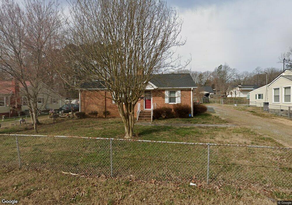
1231 Pointer St Roxboro, NC 27573
Estimated Value: $160,000 - $244,000
Studio
2
Baths
1,424
Sq Ft
$135/Sq Ft
Est. Value
About This Home
This home is located at 1231 Pointer St, Roxboro, NC 27573 and is currently estimated at $192,203, approximately $134 per square foot. 1231 Pointer St is a home located in Person County with nearby schools including Person High School, Roxboro Community School, and Roxboro Christian Academy.
Ownership History
Date
Name
Owned For
Owner Type
Purchase Details
Closed on
Nov 15, 2017
Sold by
Wilkerson Larry Ray and Wilkerson Elaine W
Bought by
Powell Timothy W
Current Estimated Value
Home Financials for this Owner
Home Financials are based on the most recent Mortgage that was taken out on this home.
Original Mortgage
$52,000
Outstanding Balance
$43,677
Interest Rate
3.94%
Mortgage Type
New Conventional
Estimated Equity
$148,526
Purchase Details
Closed on
Dec 11, 2014
Sold by
Wilkerson Peggy Oakley
Bought by
Wilkerson Peggy Oakley and Wilkerson Larry Ray
Create a Home Valuation Report for This Property
The Home Valuation Report is an in-depth analysis detailing your home's value as well as a comparison with similar homes in the area
Purchase History
| Date | Buyer | Sale Price | Title Company |
|---|---|---|---|
| Powell Timothy W | $65,000 | None Available | |
| Wilkerson Peggy Oakley | -- | None Available |
Source: Public Records
Mortgage History
| Date | Status | Borrower | Loan Amount |
|---|---|---|---|
| Open | Powell Timothy W | $52,000 |
Source: Public Records
Tax History
| Year | Tax Paid | Tax Assessment Tax Assessment Total Assessment is a certain percentage of the fair market value that is determined by local assessors to be the total taxable value of land and additions on the property. | Land | Improvement |
|---|---|---|---|---|
| 2025 | $1,955 | $141,655 | $0 | $0 |
| 2024 | $1,259 | $82,700 | $0 | $0 |
| 2023 | $1,292 | $82,700 | $0 | $0 |
| 2022 | $1,209 | $82,700 | $0 | $0 |
| 2021 | $1,133 | $82,700 | $0 | $0 |
| 2020 | $1,005 | $72,313 | $0 | $0 |
| 2019 | $1,012 | $72,313 | $0 | $0 |
| 2018 | $991 | $72,313 | $0 | $0 |
| 2017 | $991 | $72,313 | $0 | $0 |
| 2016 | $991 | $72,313 | $0 | $0 |
| 2015 | $983 | $72,313 | $0 | $0 |
| 2014 | -- | $72,313 | $0 | $0 |
Source: Public Records
Map
Nearby Homes
- 150 Summit St
- 1108 Shelton Rd
- 425 Providence Rd
- 474 Providence Rd
- 1420 John St
- 120 Denada Path
- Lot 4 Forrestwood Dr
- 11 Denada Path
- 1901 Carver Dr
- 0 Graham Dr Unit 10078034
- 513 Broad St
- 00 Stone Dr
- 143 Lankford St
- 508 Jones St
- 234 Lillian Ct
- 249 Landon Place
- 115 Kerr Dr
- 100 Landon Place
- 200 Payton Place
- 199 Payton Place
- 1233 Pointer St
- 1227 Pointer St
- 1235 Pointer St
- 1223 Pointer St
- 1214 Dolly St
- 1218 Dolly St
- 1212 Dolly St
- 1232 Pointer St
- 1222 Dolly St
- 1217 Pointer St
- 1245 Pointer St
- 1218 Pointer St
- 1226 Dolly St
- 1238 Dolly St
- 1234 Dolly St
- 1230 Dolly St
- 1215 Pointer St
- 1216 Pointer St
- 1236 Pointer St
- 1234 Pointer St
Your Personal Tour Guide
Ask me questions while you tour the home.