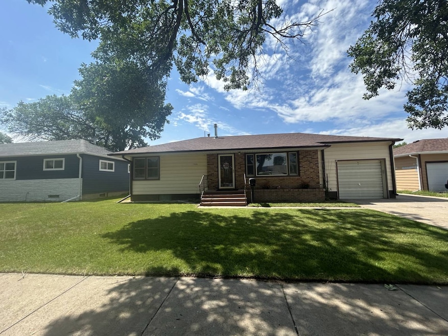


1232 Emerson Ave Alliance, NE 69301
Estimated payment $1,121/month
Highlights
- Open Floorplan
- 1 Fireplace
- 1 Car Attached Garage
- Wood Flooring
- Screened Porch
- Living Room
About This Home
Happiness for all! Mom has her attached garage and dad has his man cave. This 2 bedroom (on the main floor) house is a perfect location for schools and so much more. Hard wood floors and a nice open floor plan. The large sunroom on the west side of the house also, has the main floor laundry. The laundry is also, hooked up downstairs. There is a full bath on the main floor, but a nice bath with a walk-in shower, in the basement area. There is a potential for a bedroom in the basement and a very large family room with a3-sided glass screened gas fireplace. The sewer line has recently been professionally cleaned by Gering Plumbing. It's in great condition. This one is move in ready! Call for your private showing today.
Home Details
Home Type
- Single Family
Est. Annual Taxes
- $1,453
Year Built
- Built in 1952
Parking
- 1 Car Attached Garage
- Driveway
Home Design
- Brick Exterior Construction
- Asphalt Roof
- Block Exterior
Interior Spaces
- 925 Sq Ft Home
- 1-Story Property
- Open Floorplan
- 1 Fireplace
- Family Room
- Living Room
- Screened Porch
- Partially Finished Basement
- Basement Fills Entire Space Under The House
Kitchen
- Oven
- Dishwasher
- Laminate Countertops
- Disposal
Flooring
- Wood
- Carpet
Bedrooms and Bathrooms
- 2 Bedrooms
- 1 Full Bathroom
Laundry
- Laundry Room
- Dryer
- Washer
Utilities
- Forced Air Heating and Cooling System
- Heating System Uses Natural Gas
Additional Features
- Shed
- 9,100 Sq Ft Lot
Map
Home Values in the Area
Average Home Value in this Area
Tax History
| Year | Tax Paid | Tax Assessment Tax Assessment Total Assessment is a certain percentage of the fair market value that is determined by local assessors to be the total taxable value of land and additions on the property. | Land | Improvement |
|---|---|---|---|---|
| 2025 | $1,453 | $127,305 | $10,010 | $117,295 |
| 2024 | $1,453 | $115,980 | $9,100 | $106,880 |
| 2023 | $1,994 | $115,980 | $9,100 | $106,880 |
| 2022 | $2,012 | $110,490 | $8,190 | $102,300 |
| 2021 | $1,993 | $108,135 | $8,190 | $99,945 |
| 2020 | $1,988 | $108,135 | $8,190 | $99,945 |
| 2019 | $1,941 | $108,135 | $8,190 | $99,945 |
| 2018 | $1,932 | $108,135 | $8,190 | $99,945 |
| 2017 | $1,408 | $75,851 | $7,735 | $68,116 |
| 2016 | $1,392 | $75,851 | $7,735 | $68,116 |
| 2015 | $1,363 | $72,035 | $7,735 | $64,300 |
| 2014 | $1,363 | $73,980 | $7,735 | $66,245 |
Property History
| Date | Event | Price | List to Sale | Price per Sq Ft |
|---|---|---|---|---|
| 10/04/2025 10/04/25 | For Sale | $190,000 | -- | $205 / Sq Ft |
Purchase History
| Date | Type | Sale Price | Title Company |
|---|---|---|---|
| Warranty Deed | $176,000 | Kunzman Title |
Mortgage History
| Date | Status | Loan Amount | Loan Type |
|---|---|---|---|
| Open | $177,777 | New Conventional |
Source: My State MLS
MLS Number: 11595347
APN: 070023557
- 1232 Cheyenne Ave
- 936 Platte Ave
- 1021 Dakota Ave
- 928 Black Hills Ave
- 924 Big Horn Ave
- 819 Black Hills Ave
- 1019 Laramie Ave
- 20th St Emerson Ave To Colorado Ave
- 932 Laramie Ave
- 923 Laramie Ave
- 672 W 20th St
- 719 Toluca Ave
- 621 Emerson Ave
- 114 W 8th St
- 413 Big Horn Ave
- 324 Toluca Ave
- 1231 Missouri Ave
- 917 Missouri Ave
- 471 Anthony Ave
- 1242 Grand Ave
